Property Record
55 Hall Ave, Hubbard, OH 44425

Save to a Folder
{{folder.Name}}
{{folder.ListingIds.length}} Properties
{{folder.ListingIds.length}} Property
Create a New Folder
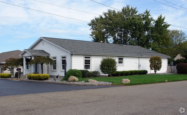
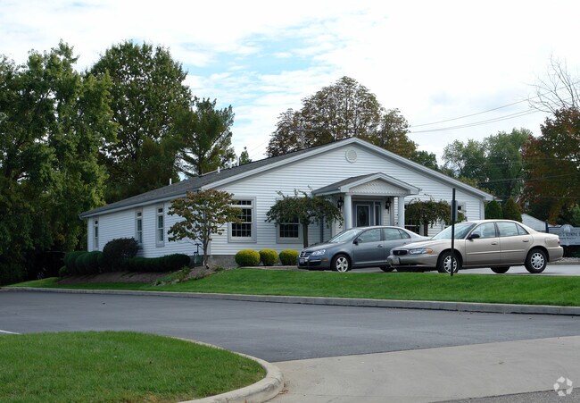
Property Detail
55 Hall Ave
Youngstown-Warren, OH
1672 60F HALL AVE HUBBARD CITY
02-299871
Trumbull
Medicalbuilding
Ohio
B and X Area of moderate flood hazard, usually the area between the limits of the 100-year and 500-year floods.
1672
2025
0.28 AC
2025
Trumbull County
931602
Youngstown/Warren/Boardman
2,424 SF
NEARBY LISTINGS FOR SALE OR LEASE
-
-
View all Hubbard listings for sale on LoopNet.com
DEMOGRAPHICS near 55 Hall Ave
1 mile
3 mile
5 mile
2025 Total Population
5,295
15,460
45,808
2030 Population
5,198
15,314
45,740
Pop Growth 2025-2030
(1.83%)
(0.94%)
(0.15%)
Average Age
44
44
42
2025 Total Households
2,507
6,749
19,329
HH Growth 2025-2030
(1.87%)
(0.98%)
(0.18%)
Median Household Inc
$58,262
$54,657
$44,226
Avg Household Size
2.10
2.20
2.20
2025 Avg HH Vehicles
2.00
2.00
2.00
Median Home Value
$144,396
$143,912
$119,446
Median Year Built
1960
1963
1959
Nearby Places
Map Layers
Map Styles
 Street
 Aerial
Layers
 Traffic
 Biking
Places
Listings with unknown addresses are not visible on the map
- Restaurants
- Banks
- Shops
- Fitness
- Groceries
Nearby Properties
Address
Land Use
TOTAL SIZE
Lot Size
Zoning
Address
Land Use
TOTAL SIZE
Lot Size
Zoning
15,762 SF
23.14 AC
Address
Land Use
TOTAL SIZE
Lot Size
Zoning
147,865 SF
29.03 AC
Address
Land Use
TOTAL SIZE
Lot Size
Zoning
56.29 AC
Address
Land Use
TOTAL SIZE
Lot Size
Zoning
4,045 SF
21.63 AC
Address
Land Use
TOTAL SIZE
Lot Size
Zoning
55,633 SF
8.75 AC
Address
Land Use
TOTAL SIZE
Lot Size
Zoning
36,544 SF
6.19 AC
Address
Land Use
TOTAL SIZE
Lot Size
Zoning
9,104 SF
4.50 AC
Address
Land Use
TOTAL SIZE
Lot Size
Zoning
17,767 SF
22.88 AC
Address
Land Use
TOTAL SIZE
Lot Size
Zoning
73,380 SF
3.74 AC
Address
Land Use
TOTAL SIZE
Lot Size
Zoning
28,979 SF
6.17 AC
Address
Land Use
TOTAL SIZE
Lot Size
Zoning
21,018 SF
4.52 AC
Address
Land Use
TOTAL SIZE
Lot Size
Zoning
9,509 SF
14.35 AC
Address
Land Use
TOTAL SIZE
Lot Size
Zoning
14,260 SF
6.72 AC
Address
Land Use
TOTAL SIZE
Lot Size
Zoning
4,200 SF
25.92 AC
Address
Land Use
TOTAL SIZE
Lot Size
Zoning
37,060 SF
3.03 AC
Address
Land Use
TOTAL SIZE
Lot Size
Zoning
28,249 SF
7.30 AC
Address
Land Use
TOTAL SIZE
Lot Size
Zoning
14,736 SF
1.57 AC
Address
Land Use
TOTAL SIZE
Lot Size
Zoning
42,426 SF
7.19 AC
Address
Land Use
TOTAL SIZE
Lot Size
Zoning
29,612 SF
79.06 AC
Address
Land Use
TOTAL SIZE
Lot Size
Zoning
43,560 SF
1.43 AC
Address
Land Use
TOTAL SIZE
Lot Size
Zoning
42,578 SF
6.22 AC
Address
Land Use
TOTAL SIZE
Lot Size
Zoning
7,368 SF
7.29 AC
Address
Land Use
TOTAL SIZE
Lot Size
Zoning
37,804 SF
3.60 AC
Address
Land Use
TOTAL SIZE
Lot Size
Zoning
15,829 SF
10.70 AC
Address
Land Use
TOTAL SIZE
Lot Size
Zoning
3,050 SF
54.88 AC
Address
Land Use
TOTAL SIZE
Lot Size
Zoning
8,450 SF
4.15 AC
Address
Land Use
TOTAL SIZE
Lot Size
Zoning
2,923 SF
156.42 AC
Address
Land Use
TOTAL SIZE
Lot Size
Zoning
11,201 SF
1.11 AC
Address
Land Use
TOTAL SIZE
Lot Size
Zoning
14,784 SF
0.78 AC
Address
Land Use
TOTAL SIZE
Lot Size
Zoning
28,446 SF
2.62 AC
The World's #1 Commercial Real Estate Marketplace
Connect with us
© 2026 CoStar Group
The information above has been obtained from sources believed reliable. While we do not doubt its accuracy we have not verified it and make no guarantee, warranty or representation about it. It is your responsibility to independently confirm its accuracy and completeness. Any projections, opinions, assumptions, or estimates used are for example only and do not represent the current or future performance of the property. The value of this transaction to you depends on tax and other factors which should be evaluated by your tax, financial, and legal advisors. You and your advisors should conduct a careful, independent investigation of the property to determine to your satisfaction the suitability of the property for your needs.