Property Record
55 Highway 50, Stateline, NV 89449
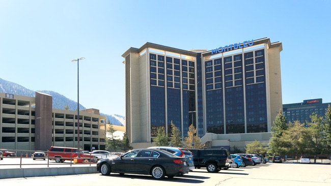

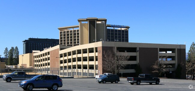
Property Detail
55 Highway 50
Gardnerville Ranchos, NV-CA
LOT PCL 2
1318-27-001-021
Douglas
Casino
Nevada
B and X Area of moderate flood hazard, usually the area between the limits of the 100-year and 500-year floods.
2
2025
17.22 AC
2026
Carson City/Nevada Area
001700
Reno/Sparks
892,616 SF
NEARBY LISTINGS FOR SALE OR LEASE
DEMOGRAPHICS near 55 Highway 50
1 mile
3 mile
5 mile
2025 Total Population
2,366
13,237
26,048
2030 Population
2,310
12,963
26,231
Pop Growth 2025-2030
(2.37%)
(2.07%)
+ 0.70%
Average Age
43
42
43
2025 Total Households
1,076
5,753
11,448
HH Growth 2025-2030
(2.51%)
(2.28%)
+ 0.57%
Median Household Inc
$59,281
$87,644
$87,783
Avg Household Size
2.10
2.20
2.20
2025 Avg HH Vehicles
2.00
2.00
2.00
Median Home Value
$1,009,441
$845,913
$886,654
Median Year Built
1975
1972
1973
Nearby Places
Map Layers
Map Styles
 Street
 Aerial
Layers
 Traffic
 Biking
Places
Listings with unknown addresses are not visible on the map
- Restaurants
- Banks
- Shops
- Fitness
- Groceries
Nearby Properties
Address
Land Use
TOTAL SIZE
Lot Size
Zoning
Address
Land Use
TOTAL SIZE
Lot Size
Zoning
3.58 AC
GC
Address
Land Use
TOTAL SIZE
Lot Size
Zoning
1,334 SF
124.88 AC
Address
Land Use
TOTAL SIZE
Lot Size
Zoning
59.73 AC
A
Address
Land Use
TOTAL SIZE
Lot Size
Zoning
991,973 SF
5.14 AC
Address
Land Use
TOTAL SIZE
Lot Size
Zoning
1,230,269 SF
21.35 AC
Address
Land Use
TOTAL SIZE
Lot Size
Zoning
2.42 AC
TC
Address
Land Use
TOTAL SIZE
Lot Size
Zoning
112,020 SF
7.61 AC
GC
Address
Land Use
TOTAL SIZE
Lot Size
Zoning
153,774 SF
14.31 AC
GC
Address
Land Use
TOTAL SIZE
Lot Size
Zoning
52,708 SF
1.21 AC
GC
Address
Land Use
TOTAL SIZE
Lot Size
Zoning
52,000 SF
2.17 AC
TC
Address
Land Use
TOTAL SIZE
Lot Size
Zoning
845,731 SF
20.83 AC
Address
Land Use
TOTAL SIZE
Lot Size
Zoning
4,946 SF
0.52 AC
TC
Address
Land Use
TOTAL SIZE
Lot Size
Zoning
52,304 SF
23.58 AC
Address
Land Use
TOTAL SIZE
Lot Size
Zoning
108,074 SF
4.91 AC
Address
Land Use
TOTAL SIZE
Lot Size
Zoning
38,492 SF
1.71 AC
Address
Land Use
TOTAL SIZE
Lot Size
Zoning
Address
Land Use
TOTAL SIZE
Lot Size
Zoning
25,089 SF
3.09 AC
Address
Land Use
TOTAL SIZE
Lot Size
Zoning
22,770 SF
0.55 AC
GC
Address
Land Use
TOTAL SIZE
Lot Size
Zoning
29,418 SF
210.26 AC
Address
Land Use
TOTAL SIZE
Lot Size
Zoning
4.69 AC
GC
Address
Land Use
TOTAL SIZE
Lot Size
Zoning
19,965 SF
24.30 AC
Address
Land Use
TOTAL SIZE
Lot Size
Zoning
29,507 SF
1.38 AC
SLT
Address
Land Use
TOTAL SIZE
Lot Size
Zoning
832,974 SF
12.85 AC
Address
Land Use
TOTAL SIZE
Lot Size
Zoning
12,720 SF
0.31 AC
GC
Address
Land Use
TOTAL SIZE
Lot Size
Zoning
31,132 SF
0.31 AC
TC
Address
Land Use
TOTAL SIZE
Lot Size
Zoning
30,714 SF
3.26 AC
GC
Address
Land Use
TOTAL SIZE
Lot Size
Zoning
14,900 SF
0.69 AC
TC
The World's #1 Commercial Real Estate Marketplace
Connect with us
© 2026 CoStar Group
The information above has been obtained from sources believed reliable. While we do not doubt its accuracy we have not verified it and make no guarantee, warranty or representation about it. It is your responsibility to independently confirm its accuracy and completeness. Any projections, opinions, assumptions, or estimates used are for example only and do not represent the current or future performance of the property. The value of this transaction to you depends on tax and other factors which should be evaluated by your tax, financial, and legal advisors. You and your advisors should conduct a careful, independent investigation of the property to determine to your satisfaction the suitability of the property for your needs.