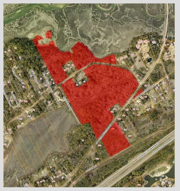
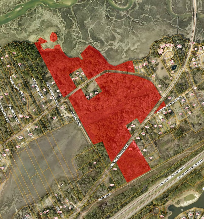
Property Record
55 Jonesville Rd, Hilton Head Island, SC 29926

NEARBY LISTINGS FOR SALE OR LEASE
Property Detail
55 Jonesville Rd
Other Market Areas
Rural Hilton Head
Hilton Head Island-Bluffton-Port Royal, SC
PARS A1-A4 B-D HRS S D WRIGHT *TOT AC INC1.87 AC WETLANDS PB152 PG96-97 PB114 PG
R510-007-000-0082-0000
Beaufort
Residentialacreage
South Carolina
2025
29.91 AC
2024
Hilton Head/Beaufort
010400
DEMOGRAPHICS near 55 Jonesville Rd
1 Mile
3 Mile
5 Mile
2024 Total Population
2,337
23,198
50,758
2029 Population
2,612
26,221
58,792
Pop Growth 2024-2029
+ 11.77%
+ 13.03%
+ 15.83%
Average Age
46
50
52
2024 Total Households
934
10,105
23,379
HH Growth 2024-2029
+ 11.03%
+ 12.77%
+ 15.83%
Median Household Inc
$110,317
$81,580
$79,787
Avg Household Size
2.30
2.20
2.10
2024 Avg HH Vehicles
2.00
2.00
2.00
Median Home Value
$479,591
$524,199
$525,474
Median Year Built
2002
1992
1989
Nearby Places
Map Layers
Map Styles
 Street
 Aerial
- Restaurants
- Banks
- Shops
- Fitness
- Groceries
PUBLIC TRANSPORTATION
AIRPORT
Hilton Head
DRIVE
WALK
Distance
Hilton Head
9 min
4.6 mi
Savannah/Hilton Head International
DRIVE
WALK
Distance
Savannah/Hilton Head International
58 min
42.0 mi
Freight Ports
Georgia Ports - Savannah
DRIVE
WALK
Distance
Georgia Ports - Savannah
54 min
40.4 mi
SALE & LEASE HISTORY
LISTING DATE
SALE/LEASE

Sep 24, 2016
For Sale
Jun 20, 2017
For Sale
Nearby Properties
Address
Land Use
TOTAL SIZE
Lot Size
Zoning
Address
Land Use
TOTAL SIZE
Lot Size
Zoning
960 SF
3,900 AC
6106
Address
Land Use
TOTAL SIZE
Lot Size
Zoning
99,058 SF
30.34 AC
6615
Address
Land Use
TOTAL SIZE
Lot Size
Zoning
16,424 SF
13.89 AC
6615
Address
Land Use
TOTAL SIZE
Lot Size
Zoning
3,400 SF
4.97 AC
Address
Land Use
TOTAL SIZE
Lot Size
Zoning
313,171 SF
4.45 AC
Address
Land Use
TOTAL SIZE
Lot Size
Zoning
Address
Land Use
TOTAL SIZE
Lot Size
Zoning
145,864 SF
49.71 AC
6615
Address
Land Use
TOTAL SIZE
Lot Size
Zoning
187,534 SF
14.92 AC
6615
Address
Land Use
TOTAL SIZE
Lot Size
Zoning
980 SF
38.06 AC
6615
Address
Land Use
TOTAL SIZE
Lot Size
Zoning
123,912 SF
21.80 AC
6615
Address
Land Use
TOTAL SIZE
Lot Size
Zoning
133,565 SF
44 AC
6615
Address
Land Use
TOTAL SIZE
Lot Size
Zoning
7,488 SF
10 AC
6615
Address
Land Use
TOTAL SIZE
Lot Size
Zoning
80,867 SF
11.29 AC
6615
Address
Land Use
TOTAL SIZE
Lot Size
Zoning
31,200 SF
10.60 AC
6615
Address
Land Use
TOTAL SIZE
Lot Size
Zoning
93,782 SF
7.61 AC
6615
Address
Land Use
TOTAL SIZE
Lot Size
Zoning
71,118 SF
13.61 AC
6615
Address
Land Use
TOTAL SIZE
Lot Size
Zoning
57,094 SF
12.38 AC
6615
Address
Land Use
TOTAL SIZE
Lot Size
Zoning
13,380 SF
5.74 AC
6615
Address
Land Use
TOTAL SIZE
Lot Size
Zoning
45,195 SF
5.98 AC
6605
Address
Land Use
TOTAL SIZE
Lot Size
Zoning
19,729 SF
5.46 AC
6615
Address
Land Use
TOTAL SIZE
Lot Size
Zoning
19,289 SF
13.95 AC
6615
Address
Land Use
TOTAL SIZE
Lot Size
Zoning
13,680 SF
5.50 AC
6615
Address
Land Use
TOTAL SIZE
Lot Size
Zoning
35,880 SF
10.23 AC
6615
Address
Land Use
TOTAL SIZE
Lot Size
Zoning
1,440 SF
179.56 AC
6615
Address
Land Use
TOTAL SIZE
Lot Size
Zoning
192 SF
70.94 AC
6615
Address
Land Use
TOTAL SIZE
Lot Size
Zoning
7,153 SF
7.22 AC
6615
Address
Land Use
TOTAL SIZE
Lot Size
Zoning
9,848 SF
4.92 AC
6615
Address
Land Use
TOTAL SIZE
Lot Size
Zoning
2,666 SF
1.38 AC
6615
Address
Land Use
TOTAL SIZE
Lot Size
Zoning
8,918 SF
184.69 AC
6815
Address
Land Use
TOTAL SIZE
Lot Size
Zoning
75,380 SF
10 AC
6605
The World's #1 Commercial Real Estate Marketplace
Connect with us
© 2026 CoStar Group
The information above has been obtained from sources believed reliable. While we do not doubt its accuracy we have not verified it and make no guarantee, warranty or representation about it. It is your responsibility to independently confirm its accuracy and completeness. Any projections, opinions, assumptions, or estimates used are for example only and do not represent the current or future performance of the property. The value of this transaction to you depends on tax and other factors which should be evaluated by your tax, financial, and legal advisors. You and your advisors should conduct a careful, independent investigation of the property to determine to your satisfaction the suitability of the property for your needs.