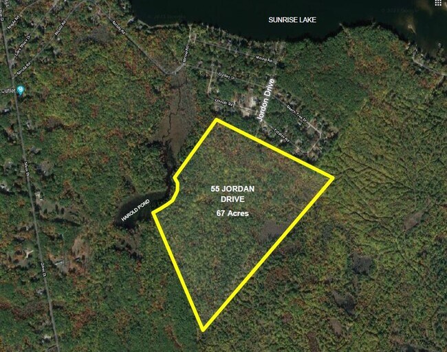
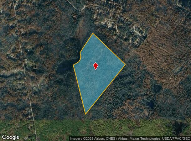
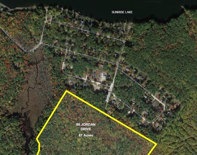
Property Record
55 Jordan Dr, Middleton, NH 03887
NEARBY LISTINGS FOR SALE OR LEASE
-
-
View all Middleton listings for sale on LoopNet.com
Property Detail
55 Jordan Dr
MDDN-000002-000000-000007
Strafford
Residentialacreage
New Hampshire
X
7
33003C0825D
67 AC
2024
Strafford County
2024
Boston
088500
Boston-Cambridge-Newton, MA-NH
DEMOGRAPHICS near 55 Jordan Dr
1 Mile
3 Mile
5 Mile
2024 Total Population
733
2,973
10,911
2029 Population
775
3,125
11,410
Pop Growth 2024-2029
+ 5.73%
+ 5.11%
+ 4.57%
Average Age
43
43
43
2024 Total Households
283
1,173
4,404
HH Growth 2024-2029
+ 6.01%
+ 5.20%
+ 4.59%
Median Household Inc
$100,926
$101,608
$89,218
Avg Household Size
2.60
2.50
2.40
2024 Avg HH Vehicles
2.00
2.00
2.00
Median Home Value
$283,333
$277,233
$266,546
Median Year Built
1979
1980
1977
Nearby Places
Map Layers
Map Styles
 Street
 Aerial
- Restaurants
- Banks
- Shops
- Fitness
- Groceries
PUBLIC TRANSPORTATION
AIRPORT
Portsmouth International at Pease
DRIVE
WALK
Distance
Portsmouth International at Pease
55 min
32.7 mi
Freight Ports
Portland, ME
DRIVE
WALK
Distance
Portland, ME
92 min
57.4 mi
SALE & LEASE HISTORY
LISTING DATE
SALE/LEASE

Sep 26, 2022
For Sale
Sep 14, 2021
For Sale
Jan 11, 2023
For Sale
Nearby Properties
Address
Land Use
TOTAL SIZE
Lot Size
Zoning
Address
Land Use
TOTAL SIZE
Lot Size
Zoning
29,120 SF
60.50 AC
M4C FO
Address
Land Use
TOTAL SIZE
Lot Size
Zoning
18,082 SF
29.86 AC
B1 RES
Address
Land Use
TOTAL SIZE
Lot Size
Zoning
13,685 SF
349.88 AC
COMM/R
Address
Land Use
TOTAL SIZE
Lot Size
Zoning
2,736 SF
53 AC
RAR
Address
Land Use
TOTAL SIZE
Lot Size
Zoning
48,339 SF
36.64 AC
B1 RES
Address
Land Use
TOTAL SIZE
Lot Size
Zoning
92.02 AC
B1 RES
Address
Land Use
TOTAL SIZE
Lot Size
Zoning
20,844 SF
2.60 AC
B1 RES
Address
Land Use
TOTAL SIZE
Lot Size
Zoning
1.56 AC
SUNRIS
Address
Land Use
TOTAL SIZE
Lot Size
Zoning
1,756 SF
16.50 AC
LOW DE
Address
Land Use
TOTAL SIZE
Lot Size
Zoning
1,778 SF
4 AC
RR RUR
Address
Land Use
TOTAL SIZE
Lot Size
Zoning
5.02 AC
B1 RES
Address
Land Use
TOTAL SIZE
Lot Size
Zoning
6,169 SF
20 AC
LOW DE
Address
Land Use
TOTAL SIZE
Lot Size
Zoning
2,255 SF
3.10 AC
M4C FO
Address
Land Use
TOTAL SIZE
Lot Size
Zoning
4,428 SF
5.47 AC
RR RUR
Address
Land Use
TOTAL SIZE
Lot Size
Zoning
1,537 SF
0.59 AC
SUNRIS
Address
Land Use
TOTAL SIZE
Lot Size
Zoning
4,180 SF
11.78 AC
RR RUR
Address
Land Use
TOTAL SIZE
Lot Size
Zoning
4,547 SF
43.60 AC
RR RUR
Address
Land Use
TOTAL SIZE
Lot Size
Zoning
734 SF
37 AC
SUNRIS
Address
Land Use
TOTAL SIZE
Lot Size
Zoning
4,046 SF
2.40 AC
M4C FO
Address
Land Use
TOTAL SIZE
Lot Size
Zoning
3,446 SF
135.27 AC
LOW DE
Address
Land Use
TOTAL SIZE
Lot Size
Zoning
3,102 SF
3.22 AC
RR RUR
Address
Land Use
TOTAL SIZE
Lot Size
Zoning
210.31 AC
RR RUR
Address
Land Use
TOTAL SIZE
Lot Size
Zoning
4,863 SF
44.58 AC
LOW DE
Address
Land Use
TOTAL SIZE
Lot Size
Zoning
2,506 SF
3.52 AC
LOW DE
Address
Land Use
TOTAL SIZE
Lot Size
Zoning
5.11 AC
RURAL
Address
Land Use
TOTAL SIZE
Lot Size
Zoning
1,330 SF
3.47 AC
LOW DE
Address
Land Use
TOTAL SIZE
Lot Size
Zoning
3,507 SF
2 AC
M4C FO
Address
Land Use
TOTAL SIZE
Lot Size
Zoning
1,425 SF
7.02 AC
RURAL
Address
Land Use
TOTAL SIZE
Lot Size
Zoning
3,089 SF
9.71 AC
LOW DE
Address
Land Use
TOTAL SIZE
Lot Size
Zoning
2,781 SF
4.40 AC
RURAL
The World's #1 Commercial Real Estate Marketplace
Connect with us
© 2025 CoStar Group
The information above has been obtained from sources believed reliable. While we do not doubt its accuracy we have not verified it and make no guarantee, warranty or representation about it. It is your responsibility to independently confirm its accuracy and completeness. Any projections, opinions, assumptions, or estimates used are for example only and do not represent the current or future performance of the property. The value of this transaction to you depends on tax and other factors which should be evaluated by your tax, financial, and legal advisors. You and your advisors should conduct a careful, independent investigation of the property to determine to your satisfaction the suitability of the property for your needs.