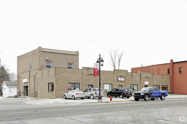
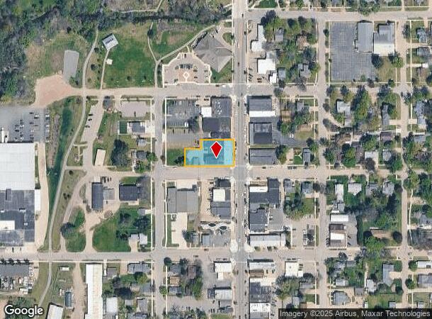
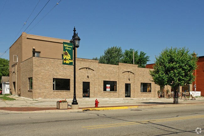
Property Record
55 N Main St, Cedar Springs, MI 49319
NEARBY LISTINGS FOR SALE OR LEASE
Property Detail
55 N Main St
Grand Rapids-Wyoming, MI
Replatted City Of Cedar Springs
41-02-25-430-011
PART OF LOTS 5 6 7 & 8 BLK 21 COM AT SE COR OF SD LOT 8 TH W 198 FT TH N 72 FT TH E 66 FT TH N 34 FT TH E 132 FT TH S 106 FT
Storebuilding
Kent
X
Michigan
26081C0181D
5-8
2024
0.43 AC
2025
Outlying Kent County
010200
West Michigan
8,070 SF
DEMOGRAPHICS near 55 N Main St
1 Mile
3 Mile
5 Mile
2024 Total Population
3,939
9,758
21,016
2029 Population
3,983
9,889
21,278
Pop Growth 2024-2029
+ 1.12%
+ 1.34%
+ 1.25%
Average Age
36
39
39
2024 Total Households
1,405
3,522
7,515
HH Growth 2024-2029
+ 1.21%
+ 1.39%
+ 1.26%
Median Household Inc
$50,718
$68,818
$82,343
Avg Household Size
2.70
2.70
2.80
2024 Avg HH Vehicles
2.00
2.00
2.00
Median Home Value
$203,519
$228,756
$246,053
Median Year Built
1968
1988
1992
Nearby Places
Map Layers
Map Styles
 Street
 Aerial
- Restaurants
- Banks
- Shops
- Fitness
- Groceries
PUBLIC TRANSPORTATION
AIRPORT
Gerald R Ford International
DRIVE
WALK
Distance
Gerald R Ford International
44 min
29.0 mi
Freight Ports
Port Milwaukee
DRIVE
WALK
Distance
Port Milwaukee
329 min
283.0 mi
SALE & LEASE HISTORY
LISTING DATE
SALE/LEASE

Sep 24, 2016
For Sale
Oct 22, 2020
For Lease
Nearby Properties
Address
Land Use
TOTAL SIZE
Lot Size
Zoning
Address
Land Use
TOTAL SIZE
Lot Size
Zoning
435,600 SF
Address
Land Use
TOTAL SIZE
Lot Size
Zoning
413,330 SF
20.83 AC
I-1
Address
Land Use
TOTAL SIZE
Lot Size
Zoning
40,800 SF
109.96 AC
IC
Address
Land Use
TOTAL SIZE
Lot Size
Zoning
Address
Land Use
TOTAL SIZE
Lot Size
Zoning
48,220 SF
4.09 AC
Address
Land Use
TOTAL SIZE
Lot Size
Zoning
3,160 SF
37.37 AC
R-4
Address
Land Use
TOTAL SIZE
Lot Size
Zoning
111,520 SF
7.30 AC
I-1
Address
Land Use
TOTAL SIZE
Lot Size
Zoning
14,170 SF
4.50 AC
H-C
Address
Land Use
TOTAL SIZE
Lot Size
Zoning
8.86 AC
C2
Address
Land Use
TOTAL SIZE
Lot Size
Zoning
55,224 SF
5.87 AC
R-3
Address
Land Use
TOTAL SIZE
Lot Size
Zoning
61,816 SF
5.10 AC
H-C
Address
Land Use
TOTAL SIZE
Lot Size
Zoning
5,816 SF
10.46 AC
HC
Address
Land Use
TOTAL SIZE
Lot Size
Zoning
50,610 SF
6.47 AC
H-C
Address
Land Use
TOTAL SIZE
Lot Size
Zoning
20 AC
MHP
Address
Land Use
TOTAL SIZE
Lot Size
Zoning
1,800 SF
75 AC
MHP
Address
Land Use
TOTAL SIZE
Lot Size
Zoning
3,056 SF
3.27 AC
HC
Address
Land Use
TOTAL SIZE
Lot Size
Zoning
38,473 SF
8.61 AC
R-3
Address
Land Use
TOTAL SIZE
Lot Size
Zoning
24,800 SF
3.90 AC
Address
Land Use
TOTAL SIZE
Lot Size
Zoning
572 SF
16.47 AC
R-4
Address
Land Use
TOTAL SIZE
Lot Size
Zoning
14,653 SF
1.80 AC
H-C
Address
Land Use
TOTAL SIZE
Lot Size
Zoning
13,520 SF
Address
Land Use
TOTAL SIZE
Lot Size
Zoning
18,960 SF
2.94 AC
H-C
Address
Land Use
TOTAL SIZE
Lot Size
Zoning
4,632 SF
161 AC
AR
Address
Land Use
TOTAL SIZE
Lot Size
Zoning
20,468 SF
2.70 AC
B-3
Address
Land Use
TOTAL SIZE
Lot Size
Zoning
23,148 SF
2.99 AC
B-3
Address
Land Use
TOTAL SIZE
Lot Size
Zoning
16,872 SF
2.16 AC
H-C
Address
Land Use
TOTAL SIZE
Lot Size
Zoning
17,520 SF
33.28 AC
L1
Address
Land Use
TOTAL SIZE
Lot Size
Zoning
16,592 SF
2.67 AC
H-C
Address
Land Use
TOTAL SIZE
Lot Size
Zoning
5.48 AC
L1
Address
Land Use
TOTAL SIZE
Lot Size
Zoning
45,747 SF
12.57 AC
I-1
The World's #1 Commercial Real Estate Marketplace
Connect with us
© 2025 CoStar Group
The information above has been obtained from sources believed reliable. While we do not doubt its accuracy we have not verified it and make no guarantee, warranty or representation about it. It is your responsibility to independently confirm its accuracy and completeness. Any projections, opinions, assumptions, or estimates used are for example only and do not represent the current or future performance of the property. The value of this transaction to you depends on tax and other factors which should be evaluated by your tax, financial, and legal advisors. You and your advisors should conduct a careful, independent investigation of the property to determine to your satisfaction the suitability of the property for your needs.