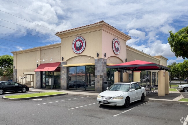
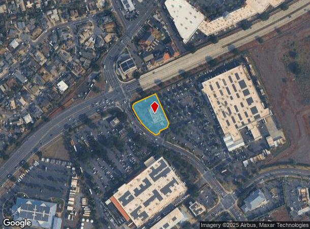
Property Record
55 Pakaula St, Kahului, HI 96732

NEARBY LISTINGS FOR SALE OR LEASE
Property Detail
55 Pakaula St
Kahului-Wailuku-Lahaina, HI
Kahului Industrial Park
2-3-8-084-014-0000
LOT 12-B KAHULUI INDUSTRIAL PARK PH 1-B 1.029 AC DES SUBJ/PORS ES 1 & ES 2
Industrialgeneral
Maui
X
Hawaii
1500030411E
12-b
2024
1.03 AC
2025
Central Maui
031900
Hawaii
6,555 SF
DEMOGRAPHICS near 55 Pakaula St
1 Mile
3 Mile
5 Mile
2024 Total Population
6,668
33,962
54,062
2029 Population
6,400
33,167
53,041
Pop Growth 2024-2029
(4.02%)
(2.34%)
(1.89%)
Average Age
40
40
40
2024 Total Households
1,661
9,672
15,652
HH Growth 2024-2029
(4.70%)
(3.00%)
(2.51%)
Median Household Inc
$83,288
$71,377
$80,992
Avg Household Size
3.50
3.20
3.20
2024 Avg HH Vehicles
2.00
2.00
2.00
Median Home Value
$709,166
$663,089
$673,803
Median Year Built
1973
1979
1986
Nearby Places
Map Layers
Map Styles
 Street
 Aerial
- Restaurants
- Banks
- Shops
- Fitness
- Groceries
PUBLIC TRANSPORTATION
AIRPORT
Kahului
DRIVE
WALK
Distance
Kahului
9 min
3.6 mi
SALE & LEASE HISTORY
LISTING DATE
SALE/LEASE

Sep 25, 2016
For Lease
Jan 26, 2021
For Lease
Dec 10, 2018
For Lease
Nearby Properties
Address
Land Use
TOTAL SIZE
Lot Size
Zoning
Address
Land Use
TOTAL SIZE
Lot Size
Zoning
14.34 AC
500
Address
Land Use
TOTAL SIZE
Lot Size
Zoning
191,252 SF
25.37 AC
420
Address
Land Use
TOTAL SIZE
Lot Size
Zoning
141,663 SF
11.88 AC
Address
Land Use
TOTAL SIZE
Lot Size
Zoning
43,434 SF
13.89 AC
410
Address
Land Use
TOTAL SIZE
Lot Size
Zoning
130,920 SF
11.42 AC
Address
Land Use
TOTAL SIZE
Lot Size
Zoning
153,273 SF
10.95 AC
Address
Land Use
TOTAL SIZE
Lot Size
Zoning
149,380 SF
12.84 AC
420
Address
Land Use
TOTAL SIZE
Lot Size
Zoning
144,519 SF
12.99 AC
410
Address
Land Use
TOTAL SIZE
Lot Size
Zoning
103,221 SF
12.93 AC
720
Address
Land Use
TOTAL SIZE
Lot Size
Zoning
234,826 SF
14.36 AC
410
Address
Land Use
TOTAL SIZE
Lot Size
Zoning
25,358 SF
9.88 AC
Address
Land Use
TOTAL SIZE
Lot Size
Zoning
4.10 AC
410
Address
Land Use
TOTAL SIZE
Lot Size
Zoning
56,906 SF
8.69 AC
410
Address
Land Use
TOTAL SIZE
Lot Size
Zoning
79,284 SF
3.35 AC
215
Address
Land Use
TOTAL SIZE
Lot Size
Zoning
94,821 SF
7.30 AC
420
Address
Land Use
TOTAL SIZE
Lot Size
Zoning
5.11 AC
Address
Land Use
TOTAL SIZE
Lot Size
Zoning
72,457 SF
2.96 AC
320
Address
Land Use
TOTAL SIZE
Lot Size
Zoning
24,848 SF
11.41 AC
500
Address
Land Use
TOTAL SIZE
Lot Size
Zoning
552,589 SF
24.60 AC
420
Address
Land Use
TOTAL SIZE
Lot Size
Zoning
81,702 SF
4.40 AC
Address
Land Use
TOTAL SIZE
Lot Size
Zoning
72,377 SF
6.06 AC
720
Address
Land Use
TOTAL SIZE
Lot Size
Zoning
53,684 SF
119.45 AC
Address
Land Use
TOTAL SIZE
Lot Size
Zoning
1.83 AC
Address
Land Use
TOTAL SIZE
Lot Size
Zoning
16.75 AC
320
Address
Land Use
TOTAL SIZE
Lot Size
Zoning
12.49 AC
Address
Land Use
TOTAL SIZE
Lot Size
Zoning
69,340 SF
5.33 AC
320
Address
Land Use
TOTAL SIZE
Lot Size
Zoning
103,520 SF
4.50 AC
720
Address
Land Use
TOTAL SIZE
Lot Size
Zoning
2.01 AC
Address
Land Use
TOTAL SIZE
Lot Size
Zoning
42,501 SF
2.59 AC
420
Address
Land Use
TOTAL SIZE
Lot Size
Zoning
191,383 SF
12.82 AC
420
The World's #1 Commercial Real Estate Marketplace
Connect with us
© 2025 CoStar Group
The information above has been obtained from sources believed reliable. While we do not doubt its accuracy we have not verified it and make no guarantee, warranty or representation about it. It is your responsibility to independently confirm its accuracy and completeness. Any projections, opinions, assumptions, or estimates used are for example only and do not represent the current or future performance of the property. The value of this transaction to you depends on tax and other factors which should be evaluated by your tax, financial, and legal advisors. You and your advisors should conduct a careful, independent investigation of the property to determine to your satisfaction the suitability of the property for your needs.