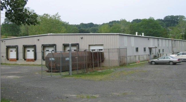
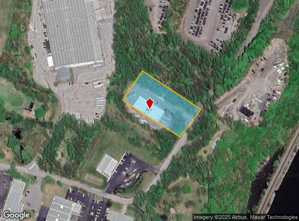
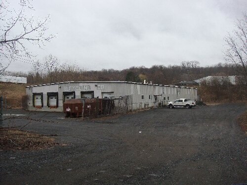
Property Record
55 Riverview Dr, Marlboro, NY 12542
NEARBY LISTINGS FOR SALE OR LEASE
Property Detail
55 Riverview Dr
3600-109.001-0002-005.120-0000
Ulster
Warehouse
New York
X
5.120
36027C0452E
2 AC
2025
Newburgh/Kingston
2024
Other Market Areas
953800
Kingston, NY
14,160 SF
DEMOGRAPHICS near 55 Riverview Dr
1 Mile
3 Mile
5 Mile
2024 Total Population
1,012
19,702
54,816
2029 Population
997
19,609
54,704
Pop Growth 2024-2029
(1.48%)
(0.47%)
(0.20%)
Average Age
44
42
42
2024 Total Households
417
7,619
21,717
HH Growth 2024-2029
(1.44%)
(0.51%)
(0.23%)
Median Household Inc
$102,232
$92,725
$97,230
Avg Household Size
2.40
2.50
2.50
2024 Avg HH Vehicles
2.00
2.00
2.00
Median Home Value
$333,593
$302,021
$336,393
Median Year Built
1978
1966
1968
Nearby Places
- Restaurants
- Banks
- Shops
- Fitness
- Groceries
PUBLIC TRANSPORTATION
COMMUTER RAIL
Poughkeepsie Station (Hudson Line - Metro-North Commuter Railroad Company (Metro-North))
DRIVE
WALK
Distance
Poughkeepsie Station (Hudson Line - Metro-North Commuter Railroad Company (Metro-North))
16 min
9.4 mi
AIRPORT
New York Stewart International
DRIVE
WALK
Distance
New York Stewart International
24 min
15.2 mi
Freight Ports
Port of New Haven
DRIVE
WALK
Distance
Port of New Haven
110 min
82.0 mi
Nearby Properties
Address
Land Use
TOTAL SIZE
Lot Size
Zoning
Address
Land Use
TOTAL SIZE
Lot Size
Zoning
193.80 AC
IH
Address
Land Use
TOTAL SIZE
Lot Size
Zoning
802,007 SF
78.21 AC
BH
Address
Land Use
TOTAL SIZE
Lot Size
Zoning
11,803 SF
99.04 AC
IH
Address
Land Use
TOTAL SIZE
Lot Size
Zoning
50,363 SF
47.88 AC
IH/R1
Address
Land Use
TOTAL SIZE
Lot Size
Zoning
16,947 SF
6.40 AC
IH
Address
Land Use
TOTAL SIZE
Lot Size
Zoning
535,543 SF
72.62 AC
BSC
Address
Land Use
TOTAL SIZE
Lot Size
Zoning
6.70 AC
R-1.5A
Address
Land Use
TOTAL SIZE
Lot Size
Zoning
98,700 SF
10 AC
BSC
Address
Land Use
TOTAL SIZE
Lot Size
Zoning
92,574 SF
9.31 AC
BH
Address
Land Use
TOTAL SIZE
Lot Size
Zoning
128,883 SF
8.63 AC
BH
Address
Land Use
TOTAL SIZE
Lot Size
Zoning
141,167 SF
46.50 AC
R1
Address
Land Use
TOTAL SIZE
Lot Size
Zoning
160,214 SF
17.47 AC
R20
Address
Land Use
TOTAL SIZE
Lot Size
Zoning
100 SF
5.70 AC
IN
Address
Land Use
TOTAL SIZE
Lot Size
Zoning
1,095 SF
21.70 AC
R1
Address
Land Use
TOTAL SIZE
Lot Size
Zoning
128,806 SF
11.93 AC
BSC
Address
Land Use
TOTAL SIZE
Lot Size
Zoning
43,877 SF
10.10 AC
R1
Address
Land Use
TOTAL SIZE
Lot Size
Zoning
64.70 AC
IND
Address
Land Use
TOTAL SIZE
Lot Size
Zoning
90,129 SF
2.90 AC
BH
Address
Land Use
TOTAL SIZE
Lot Size
Zoning
42,052 SF
4.64 AC
BH
Address
Land Use
TOTAL SIZE
Lot Size
Zoning
93,440 SF
9.99 AC
BSC
Address
Land Use
TOTAL SIZE
Lot Size
Zoning
115,384 SF
3.59 AC
BH
Address
Land Use
TOTAL SIZE
Lot Size
Zoning
22 AC
R40
Address
Land Use
TOTAL SIZE
Lot Size
Zoning
29,027 SF
4.34 AC
RM2
Address
Land Use
TOTAL SIZE
Lot Size
Zoning
43,915 SF
4.98 AC
BSC
Address
Land Use
TOTAL SIZE
Lot Size
Zoning
81,194 SF
7 AC
CB-30
Address
Land Use
TOTAL SIZE
Lot Size
Zoning
59,033 SF
87.70 AC
IN
Address
Land Use
TOTAL SIZE
Lot Size
Zoning
50,900 SF
19 AC
R20
Address
Land Use
TOTAL SIZE
Lot Size
Zoning
49,353 SF
8.47 AC
R20
Address
Land Use
TOTAL SIZE
Lot Size
Zoning
25,045 SF
4.90 AC
RAG1
Address
Land Use
TOTAL SIZE
Lot Size
Zoning
164,760 SF
9.51 AC
BSC
The World's #1 Commercial Real Estate Marketplace
Connect with us
© 2025 CoStar Group
The information above has been obtained from sources believed reliable. While we do not doubt its accuracy we have not verified it and make no guarantee, warranty or representation about it. It is your responsibility to independently confirm its accuracy and completeness. Any projections, opinions, assumptions, or estimates used are for example only and do not represent the current or future performance of the property. The value of this transaction to you depends on tax and other factors which should be evaluated by your tax, financial, and legal advisors. You and your advisors should conduct a careful, independent investigation of the property to determine to your satisfaction the suitability of the property for your needs.