Property Record
55 Silver St, Middleton, NH 03887

Save to a Folder
{{folder.Name}}
{{folder.ListingIds.length}} Properties
{{folder.ListingIds.length}} Property
Create a New Folder
Property Detail
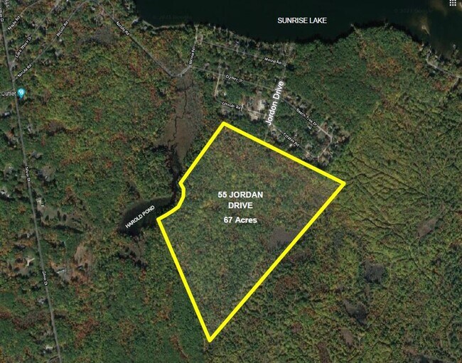
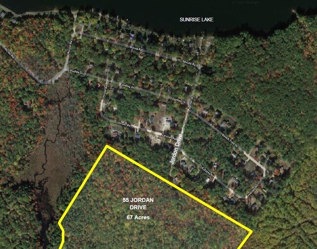
55 Silver St
MDDN-000002-000000-000007
STRAFFORD
Residentialacreage
New Hampshire
RURAL
7
B and X Area of moderate flood hazard, usually the area between the limits of the 100-year and 500-year floods.
67 AC
2025
Strafford County
2025
Boston
088500
Boston-Cambridge-Newton, MA-NH
NEARBY LISTINGS FOR SALE OR LEASE
-
-
View all Middleton listings for sale on LoopNet.com
DEMOGRAPHICS near 55 Silver St
1 mile
3 mile
5 mile
2025 Total Population
768
2,959
11,215
2030 Population
793
3,035
11,389
Pop Growth 2025-2030
+ 3.26%
+ 2.57%
+ 1.55%
Average Age
43
43
43
2025 Total Households
297
1,167
4,526
HH Growth 2025-2030
+ 3.37%
+ 2.57%
+ 1.50%
Median Household Inc
$103,373
$97,649
$73,600
Avg Household Size
2.60
2.50
2.40
2025 Avg HH Vehicles
2.00
2.00
2.00
Median Home Value
$343,150
$343,408
$331,530
Median Year Built
1981
1981
1977
Nearby Places
Map Layers
Map Styles
 Street
 Aerial
Layers
 Traffic
 Biking
Places
Listings with unknown addresses are not visible on the map
- Restaurants
- Banks
- Shops
- Fitness
- Groceries
PUBLIC TRANSPORTATION
AIRPORT
Portsmouth International at Pease
Drive
Walk
Distance
Portsmouth International at Pease
55 min
32.7 mi
Freight Ports
Portland, ME
Drive
Walk
Distance
Portland, ME
92 min
57.4 mi
SALE & LEASE HISTORY
LISTING DATE
SALE/LEASE

Sep 26, 2022
For Sale
Sep 14, 2021
For Sale
Jan 11, 2023
For Sale
Nearby Properties
Address
Land Use
TOTAL SIZE
Lot Size
Zoning
Address
Land Use
TOTAL SIZE
Lot Size
Zoning
29,120 SF
60.50 AC
M4C FO
Address
Land Use
TOTAL SIZE
Lot Size
Zoning
18,082 SF
29.86 AC
B1 RES
Address
Land Use
TOTAL SIZE
Lot Size
Zoning
13,685 SF
349.88 AC
COMM/R
Address
Land Use
TOTAL SIZE
Lot Size
Zoning
48,339 SF
36.64 AC
B1 RES
Address
Land Use
TOTAL SIZE
Lot Size
Zoning
2,736 SF
53 AC
RES/RE
Address
Land Use
TOTAL SIZE
Lot Size
Zoning
92.02 AC
B1 RES
Address
Land Use
TOTAL SIZE
Lot Size
Zoning
20,844 SF
2.60 AC
B1 RES
Address
Land Use
TOTAL SIZE
Lot Size
Zoning
1.56 AC
SUNRIS
Address
Land Use
TOTAL SIZE
Lot Size
Zoning
4,948 SF
134.01 AC
RES/RE
Address
Land Use
TOTAL SIZE
Lot Size
Zoning
1,756 SF
16.50 AC
LOW DE
Address
Land Use
TOTAL SIZE
Lot Size
Zoning
1,778 SF
4 AC
RR RUR
Address
Land Use
TOTAL SIZE
Lot Size
Zoning
5.02 AC
B1 RES
Address
Land Use
TOTAL SIZE
Lot Size
Zoning
6,169 SF
20 AC
LOW DE
Address
Land Use
TOTAL SIZE
Lot Size
Zoning
2,255 SF
3.10 AC
M4C FO
Address
Land Use
TOTAL SIZE
Lot Size
Zoning
4,428 SF
5.47 AC
RR RUR
Address
Land Use
TOTAL SIZE
Lot Size
Zoning
1,537 SF
0.59 AC
SUNRIS
Address
Land Use
TOTAL SIZE
Lot Size
Zoning
4,180 SF
11.78 AC
RR RUR
Address
Land Use
TOTAL SIZE
Lot Size
Zoning
4,547 SF
43.60 AC
RR RUR
Address
Land Use
TOTAL SIZE
Lot Size
Zoning
734 SF
37 AC
SUNRIS
Address
Land Use
TOTAL SIZE
Lot Size
Zoning
4,065 SF
2.40 AC
M4C FO
Address
Land Use
TOTAL SIZE
Lot Size
Zoning
3,446 SF
135.27 AC
LOW DE
Address
Land Use
TOTAL SIZE
Lot Size
Zoning
3,102 SF
3.22 AC
RR RUR
Address
Land Use
TOTAL SIZE
Lot Size
Zoning
210.31 AC
RR RUR
Address
Land Use
TOTAL SIZE
Lot Size
Zoning
2,506 SF
3.52 AC
LOW DE
Address
Land Use
TOTAL SIZE
Lot Size
Zoning
4,863 SF
44.58 AC
LOW DE
Address
Land Use
TOTAL SIZE
Lot Size
Zoning
5.11 AC
RURAL
Address
Land Use
TOTAL SIZE
Lot Size
Zoning
1,330 SF
3.47 AC
LOW DE
Address
Land Use
TOTAL SIZE
Lot Size
Zoning
3,529 SF
2 AC
M4C FO
Address
Land Use
TOTAL SIZE
Lot Size
Zoning
3,089 SF
9.71 AC
LOW DE
Address
Land Use
TOTAL SIZE
Lot Size
Zoning
2,719 SF
12.31 AC
B1 RES
The World's #1 Commercial Real Estate Marketplace
Connect with us
© 2026 CoStar Group
The information above has been obtained from sources believed reliable. While we do not doubt its accuracy we have not verified it and make no guarantee, warranty or representation about it. It is your responsibility to independently confirm its accuracy and completeness. Any projections, opinions, assumptions, or estimates used are for example only and do not represent the current or future performance of the property. The value of this transaction to you depends on tax and other factors which should be evaluated by your tax, financial, and legal advisors. You and your advisors should conduct a careful, independent investigation of the property to determine to your satisfaction the suitability of the property for your needs.