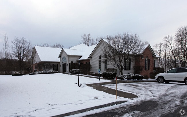
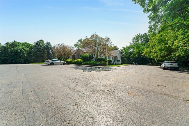
Property Record
55 Sullys Trl, Pittsford, NY 14534
NEARBY LISTINGS FOR SALE OR LEASE
Property Detail
55 Sullys Trl
264489 179.11-1-112.2 01
Metro Office Building Condominium
Officebuilding
Monroe
X
New York
36055C0387G
112.200
2025
0.04 AC
2024
Southeast
011712
Rochester
1,568 SF
Rochester, NY
DEMOGRAPHICS near 55 Sullys Trl
1 Mile
3 Mile
5 Mile
2024 Total Population
4,456
39,837
93,835
2029 Population
4,389
39,451
92,668
Pop Growth 2024-2029
(1.50%)
(0.97%)
(1.24%)
Average Age
45
45
44
2024 Total Households
1,654
16,142
38,102
HH Growth 2024-2029
(1.63%)
(1.02%)
(1.35%)
Median Household Inc
$123,174
$113,768
$100,045
Avg Household Size
2.60
2.40
2.40
2024 Avg HH Vehicles
2.00
2.00
2.00
Median Home Value
$256,560
$268,998
$270,923
Median Year Built
1970
1972
1974
Nearby Places
- Restaurants
- Banks
- Shops
- Fitness
- Groceries
PUBLIC TRANSPORTATION
AIRPORT
Frederick Douglass/Greater Rochester International
DRIVE
WALK
Distance
Frederick Douglass/Greater Rochester International
22 min
13.3 mi
Freight Ports
Albany, NY Port
DRIVE
WALK
Distance
Albany, NY Port
253 min
216.2 mi
SALE & LEASE HISTORY
LISTING DATE
SALE/LEASE

Jul 29, 2024
For Sale
Nearby Properties
Address
Land Use
TOTAL SIZE
Lot Size
Zoning
Address
Land Use
TOTAL SIZE
Lot Size
Zoning
667,703 SF
89.60 AC
COMM
Address
Land Use
TOTAL SIZE
Lot Size
Zoning
295,482 SF
83.23 AC
RES B
Address
Land Use
TOTAL SIZE
Lot Size
Zoning
177,828 SF
36.90 AC
Address
Land Use
TOTAL SIZE
Lot Size
Zoning
288,463 SF
34 AC
Address
Land Use
TOTAL SIZE
Lot Size
Zoning
191,117 SF
31.86 AC
Address
Land Use
TOTAL SIZE
Lot Size
Zoning
2,902 SF
127.70 AC
CEMETERY
Address
Land Use
TOTAL SIZE
Lot Size
Zoning
101,804 SF
26.13 AC
RESTRC BUS
Address
Land Use
TOTAL SIZE
Lot Size
Zoning
105,768 SF
51.10 AC
R-B
Address
Land Use
TOTAL SIZE
Lot Size
Zoning
196,411 SF
23.40 AC
COMMERCIAL
Address
Land Use
TOTAL SIZE
Lot Size
Zoning
174,852 SF
44 AC
Address
Land Use
TOTAL SIZE
Lot Size
Zoning
150,814 SF
20.38 AC
INDUSTRIAL
Address
Land Use
TOTAL SIZE
Lot Size
Zoning
145,904 SF
24.20 AC
PDD
Address
Land Use
TOTAL SIZE
Lot Size
Zoning
211,069 SF
22.70 AC
COMM
Address
Land Use
TOTAL SIZE
Lot Size
Zoning
7,282 SF
24.04 AC
APT
Address
Land Use
TOTAL SIZE
Lot Size
Zoning
114,692 SF
27.10 AC
RES B
Address
Land Use
TOTAL SIZE
Lot Size
Zoning
107,120 SF
9.01 AC
INDUSTRIAL
Address
Land Use
TOTAL SIZE
Lot Size
Zoning
135,844 SF
8.40 AC
COMM
Address
Land Use
TOTAL SIZE
Lot Size
Zoning
1,728 SF
85.30 AC
Address
Land Use
TOTAL SIZE
Lot Size
Zoning
72,747 SF
5.98 AC
Address
Land Use
TOTAL SIZE
Lot Size
Zoning
32,800 SF
1.50 AC
Address
Land Use
TOTAL SIZE
Lot Size
Zoning
6,768 SF
14.32 AC
APT
Address
Land Use
TOTAL SIZE
Lot Size
Zoning
155,915 SF
20.80 AC
PDD
Address
Land Use
TOTAL SIZE
Lot Size
Zoning
11,630 SF
15.80 AC
APT
Address
Land Use
TOTAL SIZE
Lot Size
Zoning
75,624 SF
19.20 AC
Address
Land Use
TOTAL SIZE
Lot Size
Zoning
122,000 SF
11.39 AC
COMMERCIAL
Address
Land Use
TOTAL SIZE
Lot Size
Zoning
130,674 SF
42 AC
RES B
Address
Land Use
TOTAL SIZE
Lot Size
Zoning
123,500 SF
8.80 AC
PDD
Address
Land Use
TOTAL SIZE
Lot Size
Zoning
75,677 SF
47.69 AC
RES B
Address
Land Use
TOTAL SIZE
Lot Size
Zoning
117,445 SF
11.86 AC
PDD
Address
Land Use
TOTAL SIZE
Lot Size
Zoning
122,402 SF
10 AC
PDD
The World's #1 Commercial Real Estate Marketplace
Connect with us
© 2025 CoStar Group
The information above has been obtained from sources believed reliable. While we do not doubt its accuracy we have not verified it and make no guarantee, warranty or representation about it. It is your responsibility to independently confirm its accuracy and completeness. Any projections, opinions, assumptions, or estimates used are for example only and do not represent the current or future performance of the property. The value of this transaction to you depends on tax and other factors which should be evaluated by your tax, financial, and legal advisors. You and your advisors should conduct a careful, independent investigation of the property to determine to your satisfaction the suitability of the property for your needs.