Property Record
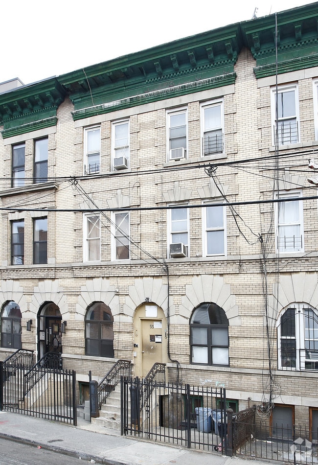
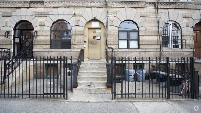
55 Troutman St, Brooklyn, NY 11206

NEARBY LISTINGS FOR SALE OR LEASE
Property Detail
55 Troutman St
03171-0056
DOCID-2020083100037004
Multifamilydwelling
Kings
X
New York
3604970208F
56
2024
0.06 AC
2025
Bushwick
039100
Long Island (New York)
6,375 SF
New York-Jersey City-White Plains, NY-NJ
DEMOGRAPHICS near 55 Troutman St
1 mile
3 mile
5 mile
2024 Total Population
178,840
1,134,108
3,112,581
2029 Population
169,498
1,069,563
2,919,701
Pop Growth 2024-2029
(5.22%)
(5.69%)
(6.20%)
Average Age
36
37
39
2024 Total Households
66,625
440,651
1,265,348
HH Growth 2024-2029
(5.84%)
(6.10%)
(6.45%)
Median Household Inc
$62,197
$71,036
$81,035
Avg Household Size
2.50
2.50
2.30
2024 Avg HH Vehicles
.00
.00
.00
Median Home Value
$928,571
$889,696
$817,150
Median Year Built
1950
1948
1949
Nearby Places
Map Layers
Map Styles
 Street
 Aerial
Transit
 Traffic
 Biking
Places
Listings with unknown addresses are not visible on the map
- Restaurants
- Banks
- Shops
- Fitness
- Groceries
PUBLIC TRANSPORTATION
TRANSIT/SUBWAY
Myrtle Avenue (J - New York MTA Subway (The Subway), M - New York MTA Subway (The Subway), Z - New York MTA Subway (The Subway))
Drive
Walk
Distance
Myrtle Avenue (J - New York MTA Subway (The Subway), M - New York MTA Subway (The Subway), Z - New York MTA Subway (The Subway))
1 min
4 min
0.2 mi
Central Avenue (M - New York MTA Subway (The Subway))
Drive
Walk
Distance
Central Avenue (M - New York MTA Subway (The Subway))
1 min
6 min
0.3 mi
Kosciuszko Street (J - New York MTA Subway (The Subway))
Drive
Walk
Distance
Kosciuszko Street (J - New York MTA Subway (The Subway))
2 min
11 min
0.6 mi
Flushing Avenue (J,M Line) (J - New York MTA Subway (The Subway), M - New York MTA Subway (The Subway))
Drive
Walk
Distance
Flushing Avenue (J,M Line) (J - New York MTA Subway (The Subway), M - New York MTA Subway (The Subway))
2 min
12 min
0.6 mi
Morgan Avenue (L - New York MTA Subway (The Subway))
Drive
Walk
Distance
Morgan Avenue (L - New York MTA Subway (The Subway))
4 min
13 min
0.7 mi
COMMUTER RAIL
Nostrand Avenue Station (Far Rockaway Branch - Long Island Rail Road, Hempstead Branch - Long Island Rail Road, Long Beach Branch - Long Island Rail Road, West Hempstead Branch - Long Island Rail Road)
Drive
Walk
Distance
Nostrand Avenue Station (Far Rockaway Branch - Long Island Rail Road, Hempstead Branch - Long Island Rail Road, Long Beach Branch - Long Island Rail Road, West Hempstead Branch - Long Island Rail Road)
8 min
2.4 mi
East New York Station (Far Rockaway Branch - Long Island Rail Road, Long Beach Branch - Long Island Rail Road, West Hempstead Branch - Long Island Rail Road)
Drive
Walk
Distance
East New York Station (Far Rockaway Branch - Long Island Rail Road, Long Beach Branch - Long Island Rail Road, West Hempstead Branch - Long Island Rail Road)
6 min
2.6 mi
AIRPORT
LaGuardia
Drive
Walk
Distance
LaGuardia
17 min
8.1 mi
John F Kennedy International
Drive
Walk
Distance
John F Kennedy International
21 min
11.9 mi
Newark Liberty International
Drive
Walk
Distance
Newark Liberty International
30 min
16.5 mi
Freight Ports
NY - Red Hook Container Terminal
Drive
Walk
Distance
NY - Red Hook Container Terminal
12 min
5.2 mi
Nearby Properties
Address
Land Use
TOTAL SIZE
Lot Size
Zoning
Address
Land Use
TOTAL SIZE
Lot Size
Zoning
2,812,739 SF
2.10 AC
C5-3
Address
Land Use
TOTAL SIZE
Lot Size
Zoning
1,104,505 SF
2.32 AC
C4-7
Address
Land Use
TOTAL SIZE
Lot Size
Zoning
7,058,736 SF
147.61 AC
M3-1
Address
Land Use
TOTAL SIZE
Lot Size
Zoning
869,038 SF
1.53 AC
M1-1
Address
Land Use
TOTAL SIZE
Lot Size
Zoning
923,000 SF
4.87 AC
R7-2
Address
Land Use
TOTAL SIZE
Lot Size
Zoning
923,000 SF
4.87 AC
R7-2
Address
Land Use
TOTAL SIZE
Lot Size
Zoning
923,000 SF
4.87 AC
R7-2
Address
Land Use
TOTAL SIZE
Lot Size
Zoning
923,000 SF
4.87 AC
R7-2
Address
Land Use
TOTAL SIZE
Lot Size
Zoning
923,000 SF
4.87 AC
R7-2
Address
Land Use
TOTAL SIZE
Lot Size
Zoning
923,000 SF
4.87 AC
R7-2
Address
Land Use
TOTAL SIZE
Lot Size
Zoning
923,000 SF
4.87 AC
R7-2
Address
Land Use
TOTAL SIZE
Lot Size
Zoning
923,000 SF
4.87 AC
R7-2
Address
Land Use
TOTAL SIZE
Lot Size
Zoning
923,000 SF
4.87 AC
R7-2
Address
Land Use
TOTAL SIZE
Lot Size
Zoning
923,000 SF
4.87 AC
R7-2
Address
Land Use
TOTAL SIZE
Lot Size
Zoning
923,000 SF
4.87 AC
R7-2
Address
Land Use
TOTAL SIZE
Lot Size
Zoning
923,000 SF
4.87 AC
R7-2
Address
Land Use
TOTAL SIZE
Lot Size
Zoning
923,000 SF
4.87 AC
R7-2
Address
Land Use
TOTAL SIZE
Lot Size
Zoning
923,000 SF
4.87 AC
R7-2
Address
Land Use
TOTAL SIZE
Lot Size
Zoning
923,000 SF
4.87 AC
R7-2
Address
Land Use
TOTAL SIZE
Lot Size
Zoning
923,000 SF
4.87 AC
R7-2
Address
Land Use
TOTAL SIZE
Lot Size
Zoning
923,000 SF
4.87 AC
R7-2
Address
Land Use
TOTAL SIZE
Lot Size
Zoning
923,000 SF
4.87 AC
R7-2
Address
Land Use
TOTAL SIZE
Lot Size
Zoning
923,000 SF
4.87 AC
R7-2
Address
Land Use
TOTAL SIZE
Lot Size
Zoning
923,000 SF
4.87 AC
R7-2
Address
Land Use
TOTAL SIZE
Lot Size
Zoning
923,000 SF
4.87 AC
R7-2
Address
Land Use
TOTAL SIZE
Lot Size
Zoning
923,000 SF
4.87 AC
R7-2
Address
Land Use
TOTAL SIZE
Lot Size
Zoning
923,000 SF
4.87 AC
R7-2
Address
Land Use
TOTAL SIZE
Lot Size
Zoning
923,000 SF
4.87 AC
R7-2
Address
Land Use
TOTAL SIZE
Lot Size
Zoning
923,000 SF
4.87 AC
R7-2
Address
Land Use
TOTAL SIZE
Lot Size
Zoning
923,000 SF
4.87 AC
R7-2
The World's #1 Commercial Real Estate Marketplace
Connect with us
© 2026 CoStar Group
The information above has been obtained from sources believed reliable. While we do not doubt its accuracy we have not verified it and make no guarantee, warranty or representation about it. It is your responsibility to independently confirm its accuracy and completeness. Any projections, opinions, assumptions, or estimates used are for example only and do not represent the current or future performance of the property. The value of this transaction to you depends on tax and other factors which should be evaluated by your tax, financial, and legal advisors. You and your advisors should conduct a careful, independent investigation of the property to determine to your satisfaction the suitability of the property for your needs.