Property Record
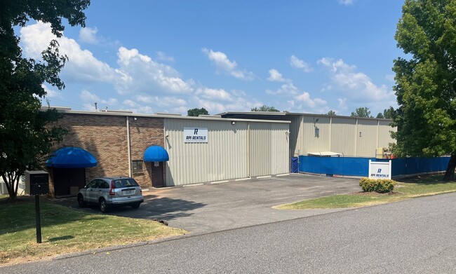
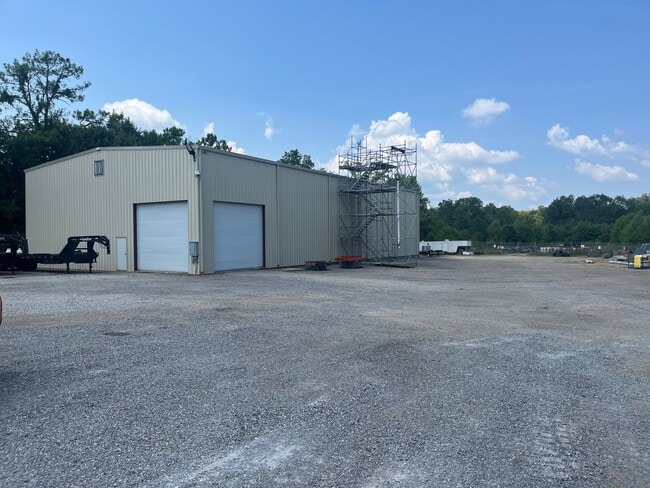
460 Belview St, Bessemer, AL 35020
This Property Is For Sale
NEARBY LISTINGS FOR SALE OR LEASE
Property Detail
460 Belview St
38-00-21-2-002-001.011
POB NW COR OF SW 1/4 OF NW 1/4 SEC 21 TSP 19S R 4W TH E 220 FT TO WLY R/W OF BELLVIEW ST TH SWLY ALG R/W 284 FT TO NLY R/W OF HOUSTON RD TH WLY ALG R/W 58 FT TO WEST LINE OF NW 1/4 TH N ALG SD LINE 224 FT TO POB
Vacantlandnec
Jefferson
X
Alabama
01073C0676G
0.70 AC
2023
Bessemer
2024
Birmingham
014301
Birmingham-Hoover, AL
DEMOGRAPHICS near 460 Belview St
1 Mile
3 Mile
5 Mile
2024 Total Population
5,293
25,294
54,388
2029 Population
5,213
24,905
53,524
Pop Growth 2024-2029
(1.51%)
(1.54%)
(1.59%)
Average Age
40
40
40
2024 Total Households
2,047
10,196
21,333
HH Growth 2024-2029
(1.66%)
(1.73%)
(1.72%)
Median Household Inc
$38,969
$39,873
$50,735
Avg Household Size
2.50
2.40
2.40
2024 Avg HH Vehicles
2.00
2.00
2.00
Median Home Value
$143,909
$139,493
$172,755
Median Year Built
1962
1968
1974
Nearby Places
Map Layers
Map Styles
 Street
 Aerial
- Restaurants
- Banks
- Shops
- Fitness
- Groceries
PUBLIC TRANSPORTATION
AIRPORT
Birmingham-Shuttlesworth International
DRIVE
WALK
Distance
Birmingham-Shuttlesworth International
32 min
22.7 mi
Freight Ports
Port of Mobile
DRIVE
WALK
Distance
Port of Mobile
283 min
237.6 mi
Nearby Properties
Address
Land Use
TOTAL SIZE
Lot Size
Zoning
Address
Land Use
TOTAL SIZE
Lot Size
Zoning
857,420 SF
34.50 AC
I3
Address
Land Use
TOTAL SIZE
Lot Size
Zoning
106 AC
I3
Address
Land Use
TOTAL SIZE
Lot Size
Zoning
929,435 SF
58 AC
I4
Address
Land Use
TOTAL SIZE
Lot Size
Zoning
184,428 SF
9.70 AC
01
Address
Land Use
TOTAL SIZE
Lot Size
Zoning
311,900 SF
30.20 AC
Address
Land Use
TOTAL SIZE
Lot Size
Zoning
178,953 SF
30 AC
C4
Address
Land Use
TOTAL SIZE
Lot Size
Zoning
210,815 SF
114 AC
I1-A
Address
Land Use
TOTAL SIZE
Lot Size
Zoning
47,705 SF
0.69 AC
01
Address
Land Use
TOTAL SIZE
Lot Size
Zoning
113,220 SF
22.60 AC
I3
Address
Land Use
TOTAL SIZE
Lot Size
Zoning
187,200 SF
22 AC
I3
Address
Land Use
TOTAL SIZE
Lot Size
Zoning
125,937 SF
7 AC
C4
Address
Land Use
TOTAL SIZE
Lot Size
Zoning
195,461 SF
15.03 AC
C3-R
Address
Land Use
TOTAL SIZE
Lot Size
Zoning
200,227 SF
25.10 AC
C-4
Address
Land Use
TOTAL SIZE
Lot Size
Zoning
175,224 SF
9.70 AC
R2
Address
Land Use
TOTAL SIZE
Lot Size
Zoning
38,868 SF
10.90 AC
C-4
Address
Land Use
TOTAL SIZE
Lot Size
Zoning
136,115 SF
14.90 AC
C3
Address
Land Use
TOTAL SIZE
Lot Size
Zoning
100,050 SF
14 AC
C-4
Address
Land Use
TOTAL SIZE
Lot Size
Zoning
122,720 SF
6.77 AC
O1-R
Address
Land Use
TOTAL SIZE
Lot Size
Zoning
137,641 SF
26.80 AC
R4
Address
Land Use
TOTAL SIZE
Lot Size
Zoning
132,116 SF
9.15 AC
R3
Address
Land Use
TOTAL SIZE
Lot Size
Zoning
132,683 SF
16 AC
R-4
Address
Land Use
TOTAL SIZE
Lot Size
Zoning
83,450 SF
4.20 AC
C4
Address
Land Use
TOTAL SIZE
Lot Size
Zoning
63.30 AC
I3
Address
Land Use
TOTAL SIZE
Lot Size
Zoning
1,090,237 SF
28.10 AC
I4
Address
Land Use
TOTAL SIZE
Lot Size
Zoning
2.50 AC
C4
Address
Land Use
TOTAL SIZE
Lot Size
Zoning
66,900 SF
3.78 AC
I4
Address
Land Use
TOTAL SIZE
Lot Size
Zoning
25,182 SF
1.76 AC
C4
Address
Land Use
TOTAL SIZE
Lot Size
Zoning
38,376 SF
4.87 AC
C3
Address
Land Use
TOTAL SIZE
Lot Size
Zoning
47,284 SF
11.30 AC
0-1/
Address
Land Use
TOTAL SIZE
Lot Size
Zoning
23,264 SF
4.06 AC
C4
The World's #1 Commercial Real Estate Marketplace
Connect with us
© 2026 CoStar Group
The information above has been obtained from sources believed reliable. While we do not doubt its accuracy we have not verified it and make no guarantee, warranty or representation about it. It is your responsibility to independently confirm its accuracy and completeness. Any projections, opinions, assumptions, or estimates used are for example only and do not represent the current or future performance of the property. The value of this transaction to you depends on tax and other factors which should be evaluated by your tax, financial, and legal advisors. You and your advisors should conduct a careful, independent investigation of the property to determine to your satisfaction the suitability of the property for your needs.