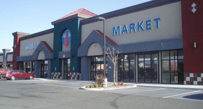
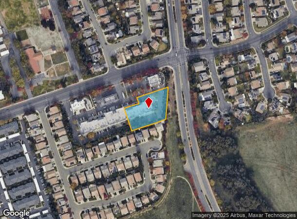
Property Record
520 Bogue Rd, Yuba City, CA 95991
NEARBY LISTINGS FOR SALE OR LEASE
Property Detail
520 Bogue Rd
Sacramento
Parcel Map 1044
Yuba City, CA
FORMERLY PTN OF 55-010-057 PARCEL 6 A SHOWN ON PARCEL MAP 1044 RECORDED IN BOOK 7 OF PARCEL MAPS, PG 14
55-010-065
Sutter
Commercialnec
California
2024
2
2025
1.05 AC
050402
Outer Sutter County
10,800 SF
DEMOGRAPHICS near 520 Bogue Rd
1 Mile
3 Mile
5 Mile
2024 Total Population
12,741
55,401
130,170
2029 Population
12,585
55,595
134,875
Pop Growth 2024-2029
(1.22%)
+ 0.35%
+ 3.61%
Average Age
38
38
38
2024 Total Households
3,894
17,329
42,651
HH Growth 2024-2029
(1.18%)
+ 0.36%
+ 3.72%
Median Household Inc
$79,562
$63,693
$61,544
Avg Household Size
3.20
3.10
3.00
2024 Avg HH Vehicles
2.00
2.00
2.00
Median Home Value
$363,258
$341,514
$332,326
Median Year Built
1995
1981
1981
Nearby Places
Map Layers
Map Styles
 Street
 Aerial
- Restaurants
- Banks
- Shops
- Fitness
- Groceries
PUBLIC TRANSPORTATION
AIRPORT
Sacramento International
DRIVE
WALK
Distance
Sacramento International
46 min
36.5 mi
Freight Ports
Port of Stockton
DRIVE
WALK
Distance
Port of Stockton
98 min
84.9 mi
SALE & LEASE HISTORY
LISTING DATE
SALE/LEASE

Nov 02, 2016
For Lease
Nearby Properties
Address
Land Use
TOTAL SIZE
Lot Size
Zoning
Address
Land Use
TOTAL SIZE
Lot Size
Zoning
18,410 SF
0.77 AC
C-3
Address
Land Use
TOTAL SIZE
Lot Size
Zoning
30,734 SF
1.38 AC
C-3
Address
Land Use
TOTAL SIZE
Lot Size
Zoning
154,480 SF
13.44 AC
C
Address
Land Use
TOTAL SIZE
Lot Size
Zoning
98,830 SF
0.40 AC
C-3
Address
Land Use
TOTAL SIZE
Lot Size
Zoning
1,028,560 SF
52.30 AC
M1
Address
Land Use
TOTAL SIZE
Lot Size
Zoning
48,348 SF
3.25 AC
Address
Land Use
TOTAL SIZE
Lot Size
Zoning
51,371 SF
10.13 AC
Address
Land Use
TOTAL SIZE
Lot Size
Zoning
120,622 SF
2.25 AC
Address
Land Use
TOTAL SIZE
Lot Size
Zoning
150,742 SF
7.91 AC
R3
Address
Land Use
TOTAL SIZE
Lot Size
Zoning
147,546 SF
7.55 AC
R3
Address
Land Use
TOTAL SIZE
Lot Size
Zoning
107,749 SF
9.33 AC
C
Address
Land Use
TOTAL SIZE
Lot Size
Zoning
49,817 SF
2.81 AC
C3
Address
Land Use
TOTAL SIZE
Lot Size
Zoning
203,353 SF
11.49 AC
C
Address
Land Use
TOTAL SIZE
Lot Size
Zoning
55,702 SF
3.16 AC
Address
Land Use
TOTAL SIZE
Lot Size
Zoning
176,181 SF
6.99 AC
CM
Address
Land Use
TOTAL SIZE
Lot Size
Zoning
137,178 SF
11.01 AC
C3
Address
Land Use
TOTAL SIZE
Lot Size
Zoning
Address
Land Use
TOTAL SIZE
Lot Size
Zoning
1.67 AC
Address
Land Use
TOTAL SIZE
Lot Size
Zoning
2.53 AC
Address
Land Use
TOTAL SIZE
Lot Size
Zoning
1,800 SF
6 AC
M-1
Address
Land Use
TOTAL SIZE
Lot Size
Zoning
79,817 SF
1.64 AC
M-1
Address
Land Use
TOTAL SIZE
Lot Size
Zoning
19,950 SF
7.66 AC
M-1
Address
Land Use
TOTAL SIZE
Lot Size
Zoning
40,045 SF
1.38 AC
C
Address
Land Use
TOTAL SIZE
Lot Size
Zoning
47,686 SF
2 AC
R2
Address
Land Use
TOTAL SIZE
Lot Size
Zoning
41,279 SF
5.18 AC
Address
Land Use
TOTAL SIZE
Lot Size
Zoning
4.79 AC
R-2
Address
Land Use
TOTAL SIZE
Lot Size
Zoning
90,130 SF
8.42 AC
Address
Land Use
TOTAL SIZE
Lot Size
Zoning
110,027 SF
8 AC
R3
Address
Land Use
TOTAL SIZE
Lot Size
Zoning
29,062 SF
1.55 AC
C3
Address
Land Use
TOTAL SIZE
Lot Size
Zoning
29,070 SF
6.84 AC
C2
The World's #1 Commercial Real Estate Marketplace
Connect with us
© 2025 CoStar Group
The information above has been obtained from sources believed reliable. While we do not doubt its accuracy we have not verified it and make no guarantee, warranty or representation about it. It is your responsibility to independently confirm its accuracy and completeness. Any projections, opinions, assumptions, or estimates used are for example only and do not represent the current or future performance of the property. The value of this transaction to you depends on tax and other factors which should be evaluated by your tax, financial, and legal advisors. You and your advisors should conduct a careful, independent investigation of the property to determine to your satisfaction the suitability of the property for your needs.