Property Record
550 Box Elder Rd W, Box Elder, SD 57719
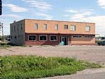


Property Detail
550 Box Elder Rd W
Rapid City, SD
S24, T2N, R08E, BLACK HILLS MERIDIAN, BAL TRACT B IN N1/2SW1/4 (S OF I-90); LOT E-F OF NE1/4SW1/4
0051224
Pennington
Publicstorage
South Dakota
AE The base floodplain where base flood elevations are provided. AE Zones are now used on new format FIRMs instead of A1-A30 Zones.
e-f
2024
7.07 AC
2025
Rapid City
011800
Other Market Areas
6,600 SF
NEARBY LISTINGS FOR SALE OR LEASE
-
-
View all Box Elder listings for sale on LoopNet.com
DEMOGRAPHICS near 550 Box Elder Rd W
1 mile
3 mile
5 mile
2025 Total Population
2,349
11,297
32,675
2030 Population
2,409
11,907
34,358
Pop Growth 2025-2030
+ 2.55%
+ 5.40%
+ 5.15%
Average Age
39
35
36
2025 Total Households
878
4,009
12,142
HH Growth 2025-2030
+ 2.16%
+ 5.89%
+ 5.44%
Median Household Inc
$76,293
$71,401
$77,879
Avg Household Size
2.60
2.60
2.60
2025 Avg HH Vehicles
3.00
2.00
2.00
Median Home Value
$241,868
$285,241
$278,348
Median Year Built
1984
2001
1998
Nearby Places
Map Layers
Map Styles
 Street
 Aerial
Transit
 Traffic
 Biking
Places
Listings with unknown addresses are not visible on the map
- Restaurants
- Banks
- Shops
- Fitness
- Groceries
PUBLIC TRANSPORTATION
AIRPORT
Rapid City Regional
Drive
Walk
Distance
Rapid City Regional
16 min
9.2 mi
Freight Ports
Tulsa Port Of Catoosa
Drive
Walk
Distance
Tulsa Port Of Catoosa
960 min
882.6 mi
Nearby Properties
Address
Land Use
TOTAL SIZE
Lot Size
Zoning
Address
Land Use
TOTAL SIZE
Lot Size
Zoning
19,781 SF
11.03 AC
Address
Land Use
TOTAL SIZE
Lot Size
Zoning
33,719 SF
8.15 AC
Address
Land Use
TOTAL SIZE
Lot Size
Zoning
2,632 SF
8.11 AC
Address
Land Use
TOTAL SIZE
Lot Size
Zoning
28,894 SF
2.17 AC
Address
Land Use
TOTAL SIZE
Lot Size
Zoning
29,196 SF
3.89 AC
Address
Land Use
TOTAL SIZE
Lot Size
Zoning
24,297 SF
5.15 AC
Address
Land Use
TOTAL SIZE
Lot Size
Zoning
39,374 SF
10 AC
Address
Land Use
TOTAL SIZE
Lot Size
Zoning
16,387 SF
2.49 AC
Address
Land Use
TOTAL SIZE
Lot Size
Zoning
16,142 SF
1.92 AC
Address
Land Use
TOTAL SIZE
Lot Size
Zoning
19,376 SF
3 AC
Address
Land Use
TOTAL SIZE
Lot Size
Zoning
15,095 SF
11.39 AC
Address
Land Use
TOTAL SIZE
Lot Size
Zoning
15,555 SF
13.30 AC
Address
Land Use
TOTAL SIZE
Lot Size
Zoning
936 SF
3.49 AC
Address
Land Use
TOTAL SIZE
Lot Size
Zoning
14,519 SF
2.52 AC
Address
Land Use
TOTAL SIZE
Lot Size
Zoning
16,795 SF
3.60 AC
Address
Land Use
TOTAL SIZE
Lot Size
Zoning
58,800 SF
6.63 AC
Address
Land Use
TOTAL SIZE
Lot Size
Zoning
8,239 SF
20 AC
Address
Land Use
TOTAL SIZE
Lot Size
Zoning
48,842 SF
5.09 AC
Address
Land Use
TOTAL SIZE
Lot Size
Zoning
11,900 SF
10.85 AC
Address
Land Use
TOTAL SIZE
Lot Size
Zoning
12,561 SF
10.01 AC
Address
Land Use
TOTAL SIZE
Lot Size
Zoning
30,000 SF
7.19 AC
Address
Land Use
TOTAL SIZE
Lot Size
Zoning
12,092 SF
2.29 AC
Address
Land Use
TOTAL SIZE
Lot Size
Zoning
12,744 SF
2.79 AC
Address
Land Use
TOTAL SIZE
Lot Size
Zoning
20,000 SF
6.83 AC
Address
Land Use
TOTAL SIZE
Lot Size
Zoning
41,250 SF
7.72 AC
Address
Land Use
TOTAL SIZE
Lot Size
Zoning
65,408 SF
14.81 AC
Address
Land Use
TOTAL SIZE
Lot Size
Zoning
9,839 SF
2.06 AC
Address
Land Use
TOTAL SIZE
Lot Size
Zoning
3,000 SF
10 AC
Address
Land Use
TOTAL SIZE
Lot Size
Zoning
10,824 SF
1.58 AC
Address
Land Use
TOTAL SIZE
Lot Size
Zoning
27,525 SF
5.83 AC
The World's #1 Commercial Real Estate Marketplace
Connect with us
© 2026 CoStar Group
The information above has been obtained from sources believed reliable. While we do not doubt its accuracy we have not verified it and make no guarantee, warranty or representation about it. It is your responsibility to independently confirm its accuracy and completeness. Any projections, opinions, assumptions, or estimates used are for example only and do not represent the current or future performance of the property. The value of this transaction to you depends on tax and other factors which should be evaluated by your tax, financial, and legal advisors. You and your advisors should conduct a careful, independent investigation of the property to determine to your satisfaction the suitability of the property for your needs.