Property Record
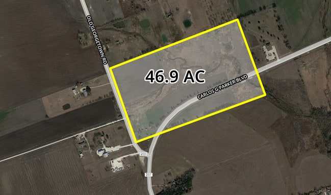
550 Carlos G Parker Blvd Nw, Taylor, TX 76574

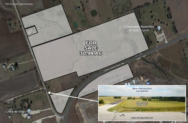
This Property Is For Sale
Property Detail
550 Carlos G Parker Blvd Nw
Austin-Round Rock-San Marcos, TX
AW0065 AW0065 - BAKER, WM. J. SUR., ACRES 30.9755
R604244
WILLIAMSON
Farms
Texas
B and X Area of moderate flood hazard, usually the area between the limits of the 100-year and 500-year floods.
30.98 AC
2024
Georgetown
2025
Austin
021000
NEARBY LISTINGS FOR SALE OR LEASE
DEMOGRAPHICS near 550 Carlos G Parker Blvd Nw
1 mile
3 mile
5 mile
2025 Total Population
3,547
17,649
21,090
2030 Population
4,077
20,172
24,154
Pop Growth 2025-2030
+ 14.94%
+ 14.30%
+ 14.53%
Average Age
40
40
40
2025 Total Households
1,290
6,609
7,891
HH Growth 2025-2030
+ 15.35%
+ 14.77%
+ 15.00%
Median Household Inc
$95,755
$70,838
$72,415
Avg Household Size
2.70
2.60
2.60
2025 Avg HH Vehicles
2.00
2.00
2.00
Median Home Value
$296,418
$313,672
$332,663
Median Year Built
2001
1982
1984
Nearby Places
Map Layers
Map Styles
 Street
 Aerial
Transit
 Traffic
 Biking
Places
Listings with unknown addresses are not visible on the map
- Restaurants
- Banks
- Shops
- Fitness
- Groceries
PUBLIC TRANSPORTATION
COMMUTER RAIL
Taylor Amtrak (Texas Eagle - Amtrak)
Drive
Walk
Distance
Taylor Amtrak (Texas Eagle - Amtrak)
9 min
4.7 mi
Freight Ports
Port of Houston
Drive
Walk
Distance
Port of Houston
205 min
166.7 mi
Nearby Properties
Address
Land Use
TOTAL SIZE
Lot Size
Zoning
Address
Land Use
TOTAL SIZE
Lot Size
Zoning
208,704 SF
20.56 AC
2-M1
Address
Land Use
TOTAL SIZE
Lot Size
Zoning
Address
Land Use
TOTAL SIZE
Lot Size
Zoning
69,997 SF
12.30 AC
3-B1
Address
Land Use
TOTAL SIZE
Lot Size
Zoning
311,017 SF
39.81 AC
Address
Land Use
TOTAL SIZE
Lot Size
Zoning
58.91 AC
Address
Land Use
TOTAL SIZE
Lot Size
Zoning
68,657 SF
117.84 AC
2-M1
Address
Land Use
TOTAL SIZE
Lot Size
Zoning
Address
Land Use
TOTAL SIZE
Lot Size
Zoning
126,732 SF
9.52 AC
Address
Land Use
TOTAL SIZE
Lot Size
Zoning
94,210 SF
17.42 AC
3-B1
Address
Land Use
TOTAL SIZE
Lot Size
Zoning
152,302 SF
17.38 AC
3-B1
Address
Land Use
TOTAL SIZE
Lot Size
Zoning
60,000 SF
15.74 AC
Address
Land Use
TOTAL SIZE
Lot Size
Zoning
72,164 SF
3.97 AC
Address
Land Use
TOTAL SIZE
Lot Size
Zoning
625 SF
51.85 AC
Address
Land Use
TOTAL SIZE
Lot Size
Zoning
15.72 AC
Address
Land Use
TOTAL SIZE
Lot Size
Zoning
18.56 AC
Address
Land Use
TOTAL SIZE
Lot Size
Zoning
46,344 SF
4.05 AC
Address
Land Use
TOTAL SIZE
Lot Size
Zoning
8.79 AC
Address
Land Use
TOTAL SIZE
Lot Size
Zoning
16,485 SF
6.75 AC
Address
Land Use
TOTAL SIZE
Lot Size
Zoning
87,200 SF
8.59 AC
Address
Land Use
TOTAL SIZE
Lot Size
Zoning
76,596 SF
2.71 AC
Address
Land Use
TOTAL SIZE
Lot Size
Zoning
35.07 AC
Address
Land Use
TOTAL SIZE
Lot Size
Zoning
37,236 SF
1.20 AC
Address
Land Use
TOTAL SIZE
Lot Size
Zoning
41,000 SF
9.90 AC
Address
Land Use
TOTAL SIZE
Lot Size
Zoning
18,136 SF
3.79 AC
3-B1
Address
Land Use
TOTAL SIZE
Lot Size
Zoning
33,080 SF
8.09 AC
Address
Land Use
TOTAL SIZE
Lot Size
Zoning
37,528 SF
5.11 AC
3-B1
Address
Land Use
TOTAL SIZE
Lot Size
Zoning
112,999 SF
6.94 AC
2-M1
Address
Land Use
TOTAL SIZE
Lot Size
Zoning
20,244 SF
2.62 AC
3-B1
Address
Land Use
TOTAL SIZE
Lot Size
Zoning
13,257 SF
1.59 AC
3-B1
Address
Land Use
TOTAL SIZE
Lot Size
Zoning
30,894 SF
2.71 AC
The World's #1 Commercial Real Estate Marketplace
Connect with us
© 2026 CoStar Group
The information above has been obtained from sources believed reliable. While we do not doubt its accuracy we have not verified it and make no guarantee, warranty or representation about it. It is your responsibility to independently confirm its accuracy and completeness. Any projections, opinions, assumptions, or estimates used are for example only and do not represent the current or future performance of the property. The value of this transaction to you depends on tax and other factors which should be evaluated by your tax, financial, and legal advisors. You and your advisors should conduct a careful, independent investigation of the property to determine to your satisfaction the suitability of the property for your needs.