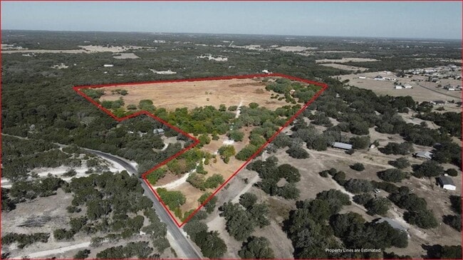
Property Record
550 County Road 281, Leander, TX 78641
Property Detail
550 County Road 281
R577895
AW0666 AW0666 - WALSH, D. SUR., ACRES 25
Agriculturalland
WILLIAMSON
B and X Area of moderate flood hazard, usually the area between the limits of the 100-year and 500-year floods.
Texas
2023
25 AC
2025
Georgetown
020330
Austin
1,782 SF
Austin-Round Rock-San Marcos, TX
NEARBY LISTINGS FOR SALE OR LEASE
DEMOGRAPHICS near 550 County Road 281
1 mile
3 mile
5 mile
2024 Total Population
736
11,457
54,702
2029 Population
962
14,730
70,008
Pop Growth 2024-2029
+ 30.71%
+ 28.57%
+ 27.98%
Average Age
39
35
36
2024 Total Households
246
3,766
18,589
HH Growth 2024-2029
+ 31.30%
+ 29.05%
+ 28.59%
Median Household Inc
$140,086
$104,877
$105,339
Avg Household Size
3.00
3.00
2.90
2024 Avg HH Vehicles
3.00
2.00
2.00
Median Home Value
$689,814
$353,538
$398,958
Median Year Built
2010
2010
2010
Nearby Places
Map Layers
Map Styles
 Street
 Aerial
Transit
 Traffic
 Biking
Places
Listings with unknown addresses are not visible on the map
- Restaurants
- Banks
- Shops
- Fitness
- Groceries
SALE & LEASE HISTORY
LISTING DATE
SALE/LEASE

Sep 25, 2024
For Sale
Sep 05, 2022
For Sale
Nearby Properties
Address
Land Use
TOTAL SIZE
Lot Size
Zoning
Address
Land Use
TOTAL SIZE
Lot Size
Zoning
435,000 SF
88.70 AC
Address
Land Use
TOTAL SIZE
Lot Size
Zoning
31.42 AC
Address
Land Use
TOTAL SIZE
Lot Size
Zoning
193,600 SF
70.78 AC
Address
Land Use
TOTAL SIZE
Lot Size
Zoning
214,488 SF
39.45 AC
Address
Land Use
TOTAL SIZE
Lot Size
Zoning
46,979 SF
5.56 AC
Address
Land Use
TOTAL SIZE
Lot Size
Zoning
105.06 AC
Address
Land Use
TOTAL SIZE
Lot Size
Zoning
24,080 SF
16.43 AC
Address
Land Use
TOTAL SIZE
Lot Size
Zoning
669.62 AC
Address
Land Use
TOTAL SIZE
Lot Size
Zoning
2,952 SF
131.47 AC
Address
Land Use
TOTAL SIZE
Lot Size
Zoning
101,012 SF
3.60 AC
Address
Land Use
TOTAL SIZE
Lot Size
Zoning
43,264 SF
5.41 AC
Address
Land Use
TOTAL SIZE
Lot Size
Zoning
53,524 SF
5 AC
Address
Land Use
TOTAL SIZE
Lot Size
Zoning
1,932 SF
315.41 AC
Address
Land Use
TOTAL SIZE
Lot Size
Zoning
7,814 SF
10.48 AC
3-C3
Address
Land Use
TOTAL SIZE
Lot Size
Zoning
8,250 SF
3.07 AC
Address
Land Use
TOTAL SIZE
Lot Size
Zoning
119.93 AC
Address
Land Use
TOTAL SIZE
Lot Size
Zoning
204.85 AC
Address
Land Use
TOTAL SIZE
Lot Size
Zoning
6,540 SF
3.08 AC
3-C3
Address
Land Use
TOTAL SIZE
Lot Size
Zoning
14,400 SF
3.49 AC
3-C3
Address
Land Use
TOTAL SIZE
Lot Size
Zoning
7,788 SF
0.88 AC
3-C3
Address
Land Use
TOTAL SIZE
Lot Size
Zoning
5,088 SF
1 AC
Address
Land Use
TOTAL SIZE
Lot Size
Zoning
6,312 SF
1.21 AC
3-C3
Address
Land Use
TOTAL SIZE
Lot Size
Zoning
11,120 SF
1.28 AC
3-C3
Address
Land Use
TOTAL SIZE
Lot Size
Zoning
61.06 AC
Address
Land Use
TOTAL SIZE
Lot Size
Zoning
5,706 SF
1.21 AC
3-C3
Address
Land Use
TOTAL SIZE
Lot Size
Zoning
22.50 AC
Address
Land Use
TOTAL SIZE
Lot Size
Zoning
14,000 SF
1.42 AC
1-C2
Address
Land Use
TOTAL SIZE
Lot Size
Zoning
138.34 AC
Address
Land Use
TOTAL SIZE
Lot Size
Zoning
11,644 SF
1.12 AC
Address
Land Use
TOTAL SIZE
Lot Size
Zoning
3,600 SF
12.50 AC
The World's #1 Commercial Real Estate Marketplace
Connect with us
© 2026 CoStar Group
The information above has been obtained from sources believed reliable. While we do not doubt its accuracy we have not verified it and make no guarantee, warranty or representation about it. It is your responsibility to independently confirm its accuracy and completeness. Any projections, opinions, assumptions, or estimates used are for example only and do not represent the current or future performance of the property. The value of this transaction to you depends on tax and other factors which should be evaluated by your tax, financial, and legal advisors. You and your advisors should conduct a careful, independent investigation of the property to determine to your satisfaction the suitability of the property for your needs.