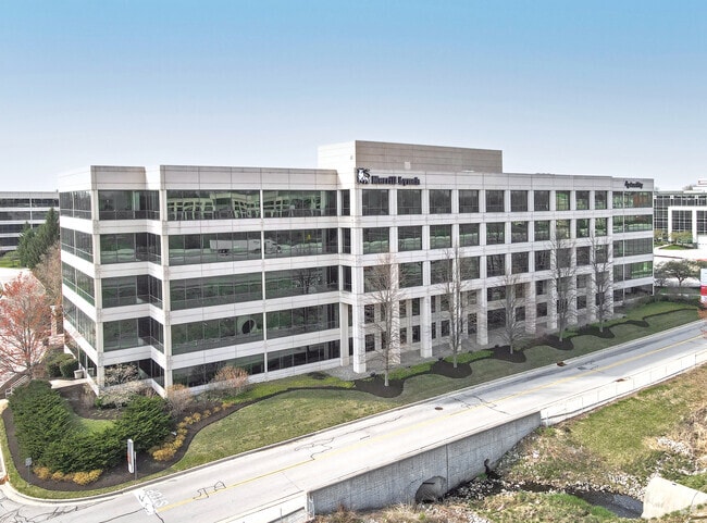
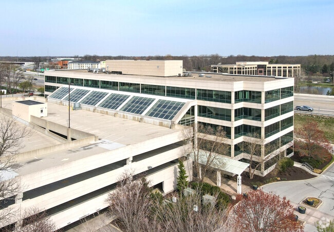
Property Record
550 E 96Th St, Indianapolis, IN 46240

Current Lease Availabilities
Property Detail
550 E 96Th St
29-13-11-417-001.009-018
ACREAGE 7.78, SECTION 11, TOWNSHIP 17, RANGE 3
Officebuilding
Marion
B and X Area of moderate flood hazard, usually the area between the limits of the 100-year and 500-year floods.
Indiana
2024
7.78 AC
2025
Meridian Corridor
111104
Indianapolis
285,284 SF
Indianapolis-Carmel-Greenwood, IN
NEARBY LISTINGS FOR SALE OR LEASE
DEMOGRAPHICS near 550 E 96Th St
1 mile
3 mile
5 mile
2025 Total Population
8,397
59,237
184,112
2030 Population
8,673
61,732
190,816
Pop Growth 2025-2030
+ 3.29%
+ 4.21%
+ 3.64%
Average Age
40
42
40
2025 Total Households
4,286
27,205
80,773
HH Growth 2025-2030
+ 2.96%
+ 4.09%
+ 3.49%
Median Household Inc
$67,567
$92,535
$94,835
Avg Household Size
1.90
2.10
2.20
2025 Avg HH Vehicles
2.00
2.00
2.00
Median Home Value
$355,555
$392,929
$398,701
Median Year Built
1976
1983
1984
Nearby Places
Map Layers
Map Styles
 Street
 Aerial
Layers
 Traffic
 Biking
Places
Listings with unknown addresses are not visible on the map
- Restaurants
- Banks
- Shops
- Fitness
- Groceries
PUBLIC TRANSPORTATION
AIRPORT
Indianapolis International
Drive
Walk
Distance
Indianapolis International
47 min
28.1 mi
Freight Ports
Port of Toledo
Drive
Walk
Distance
Port of Toledo
262 min
218.1 mi
Nearby Properties
Address
Land Use
TOTAL SIZE
Lot Size
Zoning
Address
Land Use
TOTAL SIZE
Lot Size
Zoning
303,520 SF
61.51 AC
ZO01
Address
Land Use
TOTAL SIZE
Lot Size
Zoning
239,161 SF
12.12 AC
Address
Land Use
TOTAL SIZE
Lot Size
Zoning
4,146 SF
45.91 AC
ZO01
Address
Land Use
TOTAL SIZE
Lot Size
Zoning
317,335 SF
4.14 AC
Address
Land Use
TOTAL SIZE
Lot Size
Zoning
315,968 SF
0.06 AC
ZO01
Address
Land Use
TOTAL SIZE
Lot Size
Zoning
117,212 SF
2.81 AC
ZO01
Address
Land Use
TOTAL SIZE
Lot Size
Zoning
417,894 SF
15.22 AC
Address
Land Use
TOTAL SIZE
Lot Size
Zoning
372,408 SF
12.49 AC
Address
Land Use
TOTAL SIZE
Lot Size
Zoning
408,298 SF
15.67 AC
Address
Land Use
TOTAL SIZE
Lot Size
Zoning
267,771 SF
13.10 AC
Address
Land Use
TOTAL SIZE
Lot Size
Zoning
337,250 SF
18.54 AC
Address
Land Use
TOTAL SIZE
Lot Size
Zoning
359,968 SF
13.65 AC
Address
Land Use
TOTAL SIZE
Lot Size
Zoning
428,056 SF
20.27 AC
Address
Land Use
TOTAL SIZE
Lot Size
Zoning
345 SF
6.39 AC
ZO01
Address
Land Use
TOTAL SIZE
Lot Size
Zoning
107,078 SF
15.66 AC
ZO01
Address
Land Use
TOTAL SIZE
Lot Size
Zoning
158,839 SF
0.06 AC
Address
Land Use
TOTAL SIZE
Lot Size
Zoning
10,514 SF
15.75 AC
ZO01
Address
Land Use
TOTAL SIZE
Lot Size
Zoning
288 SF
7.35 AC
ZO01
Address
Land Use
TOTAL SIZE
Lot Size
Zoning
1,904 SF
67.93 AC
ZO01
Address
Land Use
TOTAL SIZE
Lot Size
Zoning
8,157 SF
113.93 AC
ZO01
Address
Land Use
TOTAL SIZE
Lot Size
Zoning
3,316 SF
8.91 AC
ZO01
Address
Land Use
TOTAL SIZE
Lot Size
Zoning
229,554 SF
11.78 AC
ZO01
Address
Land Use
TOTAL SIZE
Lot Size
Zoning
162,462 SF
2 AC
Address
Land Use
TOTAL SIZE
Lot Size
Zoning
83,446 SF
67.68 AC
Address
Land Use
TOTAL SIZE
Lot Size
Zoning
2,544 SF
37.75 AC
ZO01
Address
Land Use
TOTAL SIZE
Lot Size
Zoning
1,700 SF
33.14 AC
ZO01
Address
Land Use
TOTAL SIZE
Lot Size
Zoning
127,922 SF
3.35 AC
ZO01
Address
Land Use
TOTAL SIZE
Lot Size
Zoning
5,149 SF
10.56 AC
ZO01
Address
Land Use
TOTAL SIZE
Lot Size
Zoning
318,050 SF
24.67 AC
ZO01
Address
Land Use
TOTAL SIZE
Lot Size
Zoning
229,856 SF
7 AC
The World's #1 Commercial Real Estate Marketplace
Connect with us
© 2026 CoStar Group
The information above has been obtained from sources believed reliable. While we do not doubt its accuracy we have not verified it and make no guarantee, warranty or representation about it. It is your responsibility to independently confirm its accuracy and completeness. Any projections, opinions, assumptions, or estimates used are for example only and do not represent the current or future performance of the property. The value of this transaction to you depends on tax and other factors which should be evaluated by your tax, financial, and legal advisors. You and your advisors should conduct a careful, independent investigation of the property to determine to your satisfaction the suitability of the property for your needs.