Property Record
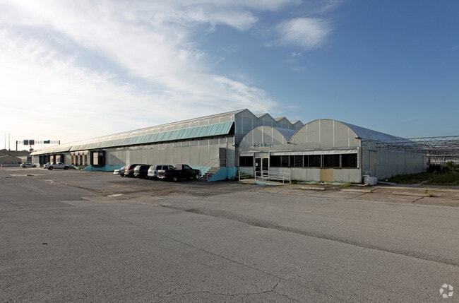
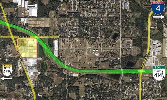
550 E Keene Rd, Apopka, FL 32703


Property Detail
550 E Keene Rd
27-2128-0000-00-030
BEG 20.83 FT S OF NW COR OF E1/2 OF SW1/4 OF NE1/4 RUN W 14. 3 FT N 86 DEG W 158.67 FT W 157.45 FT N 83 DEG W 70.85 FT N 21 DEG W 723.66 FT N 631.21 FT E 1271.65 FT TH S00-06-47E 34
Horticulturegrowinghousesagricultural
Orange
AG
Florida
B and X Area of moderate flood hazard, usually the area between the limits of the 100-year and 500-year floods.
30
2025
36.40 AC
2025
NW Orange County
017504
Orlando
114,050 SF
Orlando-Kissimmee-Sanford, FL
NEARBY LISTINGS FOR SALE OR LEASE
DEMOGRAPHICS near 550 E Keene Rd
1 mile
3 mile
5 mile
2025 Total Population
5,269
63,895
218,516
2030 Population
5,799
69,666
236,757
Pop Growth 2025-2030
+ 10.06%
+ 9.03%
+ 8.35%
Average Age
39
39
39
2025 Total Households
1,810
21,635
75,490
HH Growth 2025-2030
+ 10.50%
+ 9.42%
+ 8.62%
Median Household Inc
$91,737
$76,377
$74,870
Avg Household Size
2.80
2.90
2.80
2025 Avg HH Vehicles
2.00
2.00
2.00
Median Home Value
$421,987
$358,602
$356,058
Median Year Built
1996
1993
1988
Nearby Places
Map Layers
Map Styles
 Street
 Aerial
Transit
 Traffic
 Biking
Places
Listings with unknown addresses are not visible on the map
- Restaurants
- Banks
- Shops
- Fitness
- Groceries
PUBLIC TRANSPORTATION
AIRPORT
Orlando International
Drive
Walk
Distance
Orlando International
40 min
25.0 mi
Orlando Sanford International
Drive
Walk
Distance
Orlando Sanford International
40 min
25.8 mi
Freight Ports
Port Canaveral
Drive
Walk
Distance
Port Canaveral
85 min
67.0 mi
SALE & LEASE HISTORY
LISTING DATE
SALE/LEASE

Dec 23, 2016
For Sale
Nearby Properties
Address
Land Use
TOTAL SIZE
Lot Size
Zoning
Address
Land Use
TOTAL SIZE
Lot Size
Zoning
467,248 SF
33.67 AC
PD
Address
Land Use
TOTAL SIZE
Lot Size
Zoning
384,447 SF
10.70 AC
P-D
Address
Land Use
TOTAL SIZE
Lot Size
Zoning
373,462 SF
53.53 AC
IND-4
Address
Land Use
TOTAL SIZE
Lot Size
Zoning
537,895 SF
55.19 AC
I-L
Address
Land Use
TOTAL SIZE
Lot Size
Zoning
272,340 SF
10.78 AC
PD
Address
Land Use
TOTAL SIZE
Lot Size
Zoning
314,897 SF
21.59 AC
PD
Address
Land Use
TOTAL SIZE
Lot Size
Zoning
348,560 SF
12.96 AC
PD
Address
Land Use
TOTAL SIZE
Lot Size
Zoning
244,205 SF
28.69 AC
D-APK-MU-E
Address
Land Use
TOTAL SIZE
Lot Size
Zoning
497,045 SF
22.03 AC
RMF
Address
Land Use
TOTAL SIZE
Lot Size
Zoning
220,883 SF
53.87 AC
IND-4
Address
Land Use
TOTAL SIZE
Lot Size
Zoning
271,076 SF
19.31 AC
PUD
Address
Land Use
TOTAL SIZE
Lot Size
Zoning
375,987 SF
15.56 AC
I-L
Address
Land Use
TOTAL SIZE
Lot Size
Zoning
342,011 SF
21.15 AC
I-L
Address
Land Use
TOTAL SIZE
Lot Size
Zoning
179,970 SF
39.95 AC
A-1
Address
Land Use
TOTAL SIZE
Lot Size
Zoning
198,752 SF
38.50 AC
I-L
Address
Land Use
TOTAL SIZE
Lot Size
Zoning
193,525 SF
10.07 AC
D-APK-I-L
Address
Land Use
TOTAL SIZE
Lot Size
Zoning
185,190 SF
12.82 AC
C-C
Address
Land Use
TOTAL SIZE
Lot Size
Zoning
163,963 SF
17.16 AC
IND-1/IND-
Address
Land Use
TOTAL SIZE
Lot Size
Zoning
184,786 SF
16.44 AC
I-L
Address
Land Use
TOTAL SIZE
Lot Size
Zoning
60,028 SF
1,047.57 AC
A-1
Address
Land Use
TOTAL SIZE
Lot Size
Zoning
137,419 SF
20.08 AC
A-1
Address
Land Use
TOTAL SIZE
Lot Size
Zoning
107,978 SF
9.76 AC
MU-ES-GT
Address
Land Use
TOTAL SIZE
Lot Size
Zoning
149,832 SF
24.59 AC
IND-2/IND-
Address
Land Use
TOTAL SIZE
Lot Size
Zoning
406,432 SF
11.62 AC
I-L
Address
Land Use
TOTAL SIZE
Lot Size
Zoning
242,916 SF
25.88 AC
C-C
Address
Land Use
TOTAL SIZE
Lot Size
Zoning
152,805 SF
8.85 AC
I-L
Address
Land Use
TOTAL SIZE
Lot Size
Zoning
61,427 SF
57.66 AC
IND-2/IND-
Address
Land Use
TOTAL SIZE
Lot Size
Zoning
111,615 SF
25.92 AC
RTF
Address
Land Use
TOTAL SIZE
Lot Size
Zoning
121,241 SF
8.27 AC
D-APK-I-L
Address
Land Use
TOTAL SIZE
Lot Size
Zoning
121,241 SF
4.66 AC
I-L
The World's #1 Commercial Real Estate Marketplace
Connect with us
© 2026 CoStar Group
The information above has been obtained from sources believed reliable. While we do not doubt its accuracy we have not verified it and make no guarantee, warranty or representation about it. It is your responsibility to independently confirm its accuracy and completeness. Any projections, opinions, assumptions, or estimates used are for example only and do not represent the current or future performance of the property. The value of this transaction to you depends on tax and other factors which should be evaluated by your tax, financial, and legal advisors. You and your advisors should conduct a careful, independent investigation of the property to determine to your satisfaction the suitability of the property for your needs.