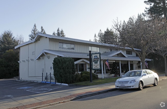
Property Record
550 Hartz Ave, Danville, CA 94526


Current Lease Availabilities
Property Detail
550 Hartz Ave
Oakland-Fremont-Berkeley, CA
HARTZ ADDN LOTS 11 & 12 BLK 1
208-022-003-7
Contra Costa
Storebuilding
California
B and X Area of moderate flood hazard, usually the area between the limits of the 100-year and 500-year floods.
11,12
2025
0.23 AC
2025
Danville/Alamo
345203
East Bay/Oakland
5,792 SF
NEARBY LISTINGS FOR SALE OR LEASE
DEMOGRAPHICS near 550 Hartz Ave
1 mile
3 mile
5 mile
2025 Total Population
9,272
43,965
101,806
2030 Population
9,422
44,182
102,450
Pop Growth 2025-2030
+ 1.62%
+ 0.49%
+ 0.63%
Average Age
45
44
45
2025 Total Households
3,609
15,919
38,613
HH Growth 2025-2030
+ 1.80%
+ 0.58%
+ 0.72%
Median Household Inc
$205,965
$222,185
$199,158
Avg Household Size
2.50
2.70
2.60
2025 Avg HH Vehicles
2.00
2.00
2.00
Median Home Value
$1,122,065
$1,129,646
$1,109,321
Median Year Built
1974
1976
1981
Nearby Places
Map Layers
Map Styles
 Street
 Aerial
Transit
 Traffic
 Biking
Places
Listings with unknown addresses are not visible on the map
- Restaurants
- Banks
- Shops
- Fitness
- Groceries
PUBLIC TRANSPORTATION
AIRPORT
Metro Oakland International
Drive
Walk
Distance
Metro Oakland International
36 min
27.9 mi
San Francisco International
Drive
Walk
Distance
San Francisco International
56 min
37.1 mi
Norman Y Mineta San Jose International
Drive
Walk
Distance
Norman Y Mineta San Jose International
49 min
38.7 mi
Nearby Properties
Address
Land Use
TOTAL SIZE
Lot Size
Zoning
Address
Land Use
TOTAL SIZE
Lot Size
Zoning
157,729 SF
4.26 AC
Address
Land Use
TOTAL SIZE
Lot Size
Zoning
80,368 SF
5.89 AC
Address
Land Use
TOTAL SIZE
Lot Size
Zoning
147,509 SF
73.78 AC
A2
Address
Land Use
TOTAL SIZE
Lot Size
Zoning
2,996 SF
4.40 AC
Address
Land Use
TOTAL SIZE
Lot Size
Zoning
140,428 SF
9.98 AC
Address
Land Use
TOTAL SIZE
Lot Size
Zoning
5,414 SF
4.73 AC
Address
Land Use
TOTAL SIZE
Lot Size
Zoning
39,831 SF
34.88 AC
R15
Address
Land Use
TOTAL SIZE
Lot Size
Zoning
67,642 SF
3.89 AC
Address
Land Use
TOTAL SIZE
Lot Size
Zoning
39,216 SF
0.92 AC
RB
Address
Land Use
TOTAL SIZE
Lot Size
Zoning
38,199 SF
9.56 AC
Address
Land Use
TOTAL SIZE
Lot Size
Zoning
78,272 SF
13.70 AC
Address
Land Use
TOTAL SIZE
Lot Size
Zoning
47,667 SF
2.78 AC
Address
Land Use
TOTAL SIZE
Lot Size
Zoning
13,390 SF
101.51 AC
P1
Address
Land Use
TOTAL SIZE
Lot Size
Zoning
86,168 SF
5.24 AC
Address
Land Use
TOTAL SIZE
Lot Size
Zoning
74,393 SF
5.67 AC
Address
Land Use
TOTAL SIZE
Lot Size
Zoning
6.03 AC
Address
Land Use
TOTAL SIZE
Lot Size
Zoning
51,462 SF
2 AC
Address
Land Use
TOTAL SIZE
Lot Size
Zoning
86,730 SF
4.28 AC
Address
Land Use
TOTAL SIZE
Lot Size
Zoning
46,168 SF
2.51 AC
Address
Land Use
TOTAL SIZE
Lot Size
Zoning
11,634 SF
8.70 AC
Address
Land Use
TOTAL SIZE
Lot Size
Zoning
26,608 SF
2.39 AC
Address
Land Use
TOTAL SIZE
Lot Size
Zoning
8,540 SF
1.87 AC
Address
Land Use
TOTAL SIZE
Lot Size
Zoning
131,247 SF
6.09 AC
Address
Land Use
TOTAL SIZE
Lot Size
Zoning
38,951 SF
2.44 AC
Address
Land Use
TOTAL SIZE
Lot Size
Zoning
12,823 SF
1.85 AC
RB
Address
Land Use
TOTAL SIZE
Lot Size
Zoning
26,415 SF
0.62 AC
Address
Land Use
TOTAL SIZE
Lot Size
Zoning
100,449 SF
2.88 AC
Address
Land Use
TOTAL SIZE
Lot Size
Zoning
5,184 SF
2.78 AC
Address
Land Use
TOTAL SIZE
Lot Size
Zoning
16,687 SF
0.46 AC
Address
Land Use
TOTAL SIZE
Lot Size
Zoning
26,593 SF
1.19 AC
The World's #1 Commercial Real Estate Marketplace
Connect with us
© 2026 CoStar Group
The information above has been obtained from sources believed reliable. While we do not doubt its accuracy we have not verified it and make no guarantee, warranty or representation about it. It is your responsibility to independently confirm its accuracy and completeness. Any projections, opinions, assumptions, or estimates used are for example only and do not represent the current or future performance of the property. The value of this transaction to you depends on tax and other factors which should be evaluated by your tax, financial, and legal advisors. You and your advisors should conduct a careful, independent investigation of the property to determine to your satisfaction the suitability of the property for your needs.