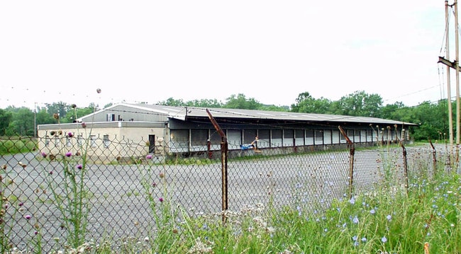
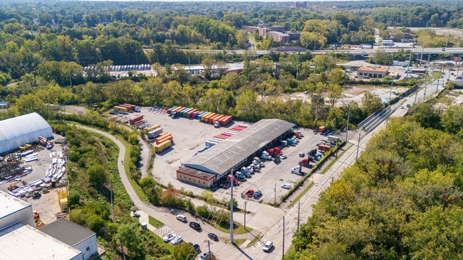
Property Record
550 Harvard Ave, Newburgh Heights, OH 44105

Current Lease Availabilities
NEARBY LISTINGS FOR SALE OR LEASE
Property Detail
550 Harvard Ave
Cleveland-Elyria, OH
Village/Cuyahoga Heights
521-05-004
OL 273 52105005 LISTED WITH
Truckterminal
Cuyahoga
AE
Ohio
39035C0183E
273
2024
4.44 AC
2024
Brooklyn Hts
196100
Cleveland
17,820 SF
DEMOGRAPHICS near 550 Harvard Ave
1 Mile
3 Mile
5 Mile
2024 Total Population
7,215
98,903
297,376
2029 Population
7,019
95,586
289,097
Pop Growth 2024-2029
(2.72%)
(3.35%)
(2.78%)
Average Age
40
39
39
2024 Total Households
3,322
43,337
131,511
HH Growth 2024-2029
(3.10%)
(3.47%)
(2.76%)
Median Household Inc
$32,220
$40,545
$42,722
Avg Household Size
2.10
2.20
2.10
2024 Avg HH Vehicles
1.00
1.00
1.00
Median Home Value
$104,155
$104,522
$112,625
Median Year Built
1953
1947
1949
Nearby Places
Map Layers
Map Styles
 Street
 Aerial
- Restaurants
- Banks
- Shops
- Fitness
- Groceries
PUBLIC TRANSPORTATION
COMMUTER RAIL
Cleveland Lakefront Station (Blue Line - Greater Cleveland Regional Transit Authority Rapid Transit (The Rapid), Green Line - Greater Cleveland Regional Transit Authority Rapid Transit (The Rapid))
DRIVE
WALK
Distance
Cleveland Lakefront Station (Blue Line - Greater Cleveland Regional Transit Authority Rapid Transit (The Rapid), Green Line - Greater Cleveland Regional Transit Authority Rapid Transit (The Rapid))
16 min
6.3 mi
DRIVE
WALK
Distance
14 min
6.5 mi
AIRPORT
Cleveland-Hopkins International
DRIVE
WALK
Distance
Cleveland-Hopkins International
22 min
11.7 mi
Nearby Properties
Address
Land Use
TOTAL SIZE
Lot Size
Zoning
Address
Land Use
TOTAL SIZE
Lot Size
Zoning
3,491,901 SF
34.32 AC
Address
Land Use
TOTAL SIZE
Lot Size
Zoning
162,711 SF
192.04 AC
IG
Address
Land Use
TOTAL SIZE
Lot Size
Zoning
3.23 AC
LLR
Address
Land Use
TOTAL SIZE
Lot Size
Zoning
257,857 SF
8.03 AC
GR
Address
Land Use
TOTAL SIZE
Lot Size
Zoning
299,507 SF
2.14 AC
LR
Address
Land Use
TOTAL SIZE
Lot Size
Zoning
2.83 AC
LLR
Address
Land Use
TOTAL SIZE
Lot Size
Zoning
164,294 SF
13.81 AC
GI
Address
Land Use
TOTAL SIZE
Lot Size
Zoning
194,257 SF
94.46 AC
IG
Address
Land Use
TOTAL SIZE
Lot Size
Zoning
595.30 AC
UI
Address
Land Use
TOTAL SIZE
Lot Size
Zoning
227,787 SF
3.40 AC
LR
Address
Land Use
TOTAL SIZE
Lot Size
Zoning
308,339 SF
9.78 AC
2F
Address
Land Use
TOTAL SIZE
Lot Size
Zoning
228,134 SF
40.65 AC
UI
Address
Land Use
TOTAL SIZE
Lot Size
Zoning
28,852 SF
8.17 AC
Address
Land Use
TOTAL SIZE
Lot Size
Zoning
372,486 SF
3.98 AC
GR
Address
Land Use
TOTAL SIZE
Lot Size
Zoning
361,287 SF
86.50 AC
2F
Address
Land Use
TOTAL SIZE
Lot Size
Zoning
142,935 SF
1.02 AC
LR
Address
Land Use
TOTAL SIZE
Lot Size
Zoning
22,928 SF
2.17 AC
LR
Address
Land Use
TOTAL SIZE
Lot Size
Zoning
104,170 SF
2.70 AC
2F
Address
Land Use
TOTAL SIZE
Lot Size
Zoning
372,786 SF
4.79 AC
MF3+
Address
Land Use
TOTAL SIZE
Lot Size
Zoning
120,061 SF
1.91 AC
GI
Address
Land Use
TOTAL SIZE
Lot Size
Zoning
500,398 SF
24.49 AC
IG
Address
Land Use
TOTAL SIZE
Lot Size
Zoning
180,175 SF
111.96 AC
IG
Address
Land Use
TOTAL SIZE
Lot Size
Zoning
209,068 SF
23.10 AC
IG
Address
Land Use
TOTAL SIZE
Lot Size
Zoning
148,877 SF
1.53 AC
MF-1
Address
Land Use
TOTAL SIZE
Lot Size
Zoning
277,049 SF
24.15 AC
2F
Address
Land Use
TOTAL SIZE
Lot Size
Zoning
19.48 AC
U5-A
Address
Land Use
TOTAL SIZE
Lot Size
Zoning
201,041 SF
12.74 AC
GI
Address
Land Use
TOTAL SIZE
Lot Size
Zoning
1.17 AC
GR
Address
Land Use
TOTAL SIZE
Lot Size
Zoning
232,763 SF
21.37 AC
UI
Address
Land Use
TOTAL SIZE
Lot Size
Zoning
75,598 SF
0.98 AC
SI
The World's #1 Commercial Real Estate Marketplace
Connect with us
© 2026 CoStar Group
The information above has been obtained from sources believed reliable. While we do not doubt its accuracy we have not verified it and make no guarantee, warranty or representation about it. It is your responsibility to independently confirm its accuracy and completeness. Any projections, opinions, assumptions, or estimates used are for example only and do not represent the current or future performance of the property. The value of this transaction to you depends on tax and other factors which should be evaluated by your tax, financial, and legal advisors. You and your advisors should conduct a careful, independent investigation of the property to determine to your satisfaction the suitability of the property for your needs.