Property Record
550 King Dr, Daly City, CA 94015
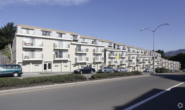

Property Detail
550 King Dr
091-601-640
R3 LOT 64 BLK 21 SERRAMONTE UNIT NO 15 RSM 73/21 23
Multifamilydwelling
San Mateo
R30000
California
B and X Area of moderate flood hazard, usually the area between the limits of the 100-year and 500-year floods.
64
2024
1.97 AC
2025
Serramonte
601603
San Francisco
78,520 SF
San Francisco-San Mateo-Redwood City, CA
NEARBY LISTINGS FOR SALE OR LEASE
DEMOGRAPHICS near 550 King Dr
1 mile
3 mile
5 mile
2025 Total Population
31,871
169,188
341,362
2030 Population
31,833
169,544
340,904
Pop Growth 2025-2030
(0.12%)
+ 0.21%
(0.13%)
Average Age
44
43
43
2025 Total Households
9,975
55,930
110,166
HH Growth 2025-2030
(0.12%)
+ 0.20%
(0.12%)
Median Household Inc
$153,772
$132,574
$126,779
Avg Household Size
3.10
2.90
3.00
2025 Avg HH Vehicles
2.00
2.00
2.00
Median Home Value
$1,070,337
$1,058,429
$1,064,244
Median Year Built
1969
1967
1961
Nearby Places
Map Layers
Map Styles
 Street
 Aerial
Layers
 Traffic
 Biking
Places
Listings with unknown addresses are not visible on the map
- Restaurants
- Banks
- Shops
- Fitness
- Groceries
PUBLIC TRANSPORTATION
COMMUTER RAIL
San Bruno Caltrain Station Southbound (Local Weekday - Caltrain (Caltrain), Local Weekend - Caltrain (Caltrain))
Drive
Walk
Distance
San Bruno Caltrain Station Southbound (Local Weekday - Caltrain (Caltrain), Local Weekend - Caltrain (Caltrain))
7 min
3.9 mi
South San Francisco Caltrain Station Northbound (Express - Caltrain (Caltrain), Limited - Caltrain (Caltrain), Local Weekday - Caltrain (Caltrain), Local Weekend - Caltrain (Caltrain))
Drive
Walk
Distance
South San Francisco Caltrain Station Northbound (Express - Caltrain (Caltrain), Limited - Caltrain (Caltrain), Local Weekday - Caltrain (Caltrain), Local Weekend - Caltrain (Caltrain))
9 min
4.3 mi
AIRPORT
San Francisco International
Drive
Walk
Distance
San Francisco International
13 min
6.4 mi
Metro Oakland International
Drive
Walk
Distance
Metro Oakland International
45 min
31.3 mi
Freight Ports
Port of San Francisco
Drive
Walk
Distance
Port of San Francisco
21 min
14.0 mi
Nearby Properties
Address
Land Use
TOTAL SIZE
Lot Size
Zoning
Address
Land Use
TOTAL SIZE
Lot Size
Zoning
6.67 AC
PD0000
Address
Land Use
TOTAL SIZE
Lot Size
Zoning
53.85 AC
Address
Land Use
TOTAL SIZE
Lot Size
Zoning
112,912 SF
5.96 AC
MH00M2
Address
Land Use
TOTAL SIZE
Lot Size
Zoning
198,375 SF
5.52 AC
PD0000
Address
Land Use
TOTAL SIZE
Lot Size
Zoning
Address
Land Use
TOTAL SIZE
Lot Size
Zoning
Address
Land Use
TOTAL SIZE
Lot Size
Zoning
167,105 SF
2.07 AC
C10000
Address
Land Use
TOTAL SIZE
Lot Size
Zoning
270,980 SF
3.33 AC
Address
Land Use
TOTAL SIZE
Lot Size
Zoning
453,076 SF
25.10 AC
Address
Land Use
TOTAL SIZE
Lot Size
Zoning
42.95 AC
Address
Land Use
TOTAL SIZE
Lot Size
Zoning
86,000 SF
4.90 AC
PD0000
Address
Land Use
TOTAL SIZE
Lot Size
Zoning
11.46 AC
Address
Land Use
TOTAL SIZE
Lot Size
Zoning
Address
Land Use
TOTAL SIZE
Lot Size
Zoning
2,588 SF
0.20 AC
Address
Land Use
TOTAL SIZE
Lot Size
Zoning
57,623 SF
2.91 AC
M20000
Address
Land Use
TOTAL SIZE
Lot Size
Zoning
144,591 SF
6.06 AC
CO0000
Address
Land Use
TOTAL SIZE
Lot Size
Zoning
105,710 SF
3.49 AC
Address
Land Use
TOTAL SIZE
Lot Size
Zoning
178,110 SF
1.67 AC
Address
Land Use
TOTAL SIZE
Lot Size
Zoning
165,936 SF
1.58 AC
CL00C1
Address
Land Use
TOTAL SIZE
Lot Size
Zoning
15.33 AC
Address
Land Use
TOTAL SIZE
Lot Size
Zoning
246,528 SF
1.04 AC
Address
Land Use
TOTAL SIZE
Lot Size
Zoning
2,025 SF
2.28 AC
Address
Land Use
TOTAL SIZE
Lot Size
Zoning
338,057 SF
5.06 AC
Address
Land Use
TOTAL SIZE
Lot Size
Zoning
231,306 SF
3.68 AC
Address
Land Use
TOTAL SIZE
Lot Size
Zoning
220,000 SF
9.80 AC
PD0000
Address
Land Use
TOTAL SIZE
Lot Size
Zoning
11.98 AC
PD0000
Address
Land Use
TOTAL SIZE
Lot Size
Zoning
154,238 SF
8.32 AC
M20000
Address
Land Use
TOTAL SIZE
Lot Size
Zoning
178,444 SF
3.29 AC
Address
Land Use
TOTAL SIZE
Lot Size
Zoning
The World's #1 Commercial Real Estate Marketplace
Connect with us
© 2026 CoStar Group
The information above has been obtained from sources believed reliable. While we do not doubt its accuracy we have not verified it and make no guarantee, warranty or representation about it. It is your responsibility to independently confirm its accuracy and completeness. Any projections, opinions, assumptions, or estimates used are for example only and do not represent the current or future performance of the property. The value of this transaction to you depends on tax and other factors which should be evaluated by your tax, financial, and legal advisors. You and your advisors should conduct a careful, independent investigation of the property to determine to your satisfaction the suitability of the property for your needs.