Property Record
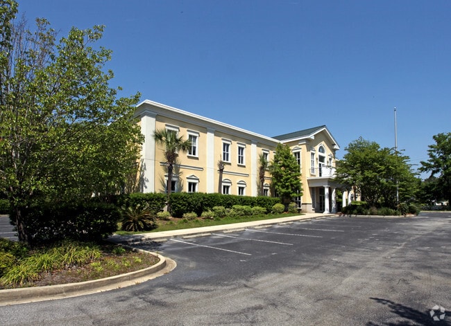
550 Long Point Rd, Mount Pleasant, SC 29464


This Property Is For Sale
Current Lease Availabilities
Property Detail
550 Long Point Rd
537-00-00-022
DESCRIPTION -PARCEL 2-D
Officebuilding
Charleston
B and X Area of moderate flood hazard, usually the area between the limits of the 100-year and 500-year floods.
South Carolina
2025
2.01 AC
2024
East Islands/Mt Pleasant
004613
Charleston/N Charleston
9,148 SF
Charleston-North Charleston, SC
NEARBY LISTINGS FOR SALE OR LEASE
DEMOGRAPHICS near 550 Long Point Rd
1 mile
3 mile
5 mile
2025 Total Population
5,822
46,033
87,539
2030 Population
5,980
47,937
92,268
Pop Growth 2025-2030
+ 2.71%
+ 4.14%
+ 5.40%
Average Age
41
42
42
2025 Total Households
2,184
19,831
37,246
HH Growth 2025-2030
+ 2.70%
+ 4.31%
+ 5.65%
Median Household Inc
$140,860
$112,941
$116,103
Avg Household Size
2.60
2.20
2.30
2025 Avg HH Vehicles
2.00
2.00
2.00
Median Home Value
$755,380
$770,517
$795,296
Median Year Built
1994
1994
1997
Nearby Places
Map Layers
Map Styles
 Street
 Aerial
Layers
 Traffic
 Biking
Places
Listings with unknown addresses are not visible on the map
- Restaurants
- Banks
- Shops
- Fitness
- Groceries
PUBLIC TRANSPORTATION
AIRPORT
Charleston AFB/International
Drive
Walk
Distance
Charleston AFB/International
17 min
13.0 mi
Nearby Properties
Address
Land Use
TOTAL SIZE
Lot Size
Zoning
Address
Land Use
TOTAL SIZE
Lot Size
Zoning
247,883 SF
16.26 AC
Address
Land Use
TOTAL SIZE
Lot Size
Zoning
29,118 SF
7.83 AC
CHARLESTON
Address
Land Use
TOTAL SIZE
Lot Size
Zoning
372,400 SF
5.59 AC
CHARLESTON
Address
Land Use
TOTAL SIZE
Lot Size
Zoning
Address
Land Use
TOTAL SIZE
Lot Size
Zoning
58,764 SF
25 AC
CHARLESTON
Address
Land Use
TOTAL SIZE
Lot Size
Zoning
29,614 SF
4.08 AC
CHARLESTON
Address
Land Use
TOTAL SIZE
Lot Size
Zoning
21,432 SF
1.27 AC
CHARLESTON
Address
Land Use
TOTAL SIZE
Lot Size
Zoning
40,130 SF
3.76 AC
CHARLESTON
Address
Land Use
TOTAL SIZE
Lot Size
Zoning
9,520 SF
2.04 AC
CHARLESTON
Address
Land Use
TOTAL SIZE
Lot Size
Zoning
11,300 SF
1.62 AC
CHARLESTON
Address
Land Use
TOTAL SIZE
Lot Size
Zoning
6.33 AC
CHARLESTON
Address
Land Use
TOTAL SIZE
Lot Size
Zoning
30,014 SF
2.24 AC
CHARLESTON
Address
Land Use
TOTAL SIZE
Lot Size
Zoning
23.21 AC
CHARLESTON
Address
Land Use
TOTAL SIZE
Lot Size
Zoning
4,128 SF
0.41 AC
CHARLESTON
Address
Land Use
TOTAL SIZE
Lot Size
Zoning
18,316 SF
14.16 AC
Address
Land Use
TOTAL SIZE
Lot Size
Zoning
21,866 SF
1.25 AC
CHARLESTON
Address
Land Use
TOTAL SIZE
Lot Size
Zoning
15,957 SF
3.80 AC
Address
Land Use
TOTAL SIZE
Lot Size
Zoning
3,462 SF
24.85 AC
Address
Land Use
TOTAL SIZE
Lot Size
Zoning
25,080 SF
1.90 AC
CHARLESTON
Address
Land Use
TOTAL SIZE
Lot Size
Zoning
CHARLESTON
Address
Land Use
TOTAL SIZE
Lot Size
Zoning
CHARLESTON
Address
Land Use
TOTAL SIZE
Lot Size
Zoning
6,572 SF
23.28 AC
Address
Land Use
TOTAL SIZE
Lot Size
Zoning
0.65 AC
CHARLESTON
Address
Land Use
TOTAL SIZE
Lot Size
Zoning
Address
Land Use
TOTAL SIZE
Lot Size
Zoning
5,000 SF
1.39 AC
CHARLESTON
Address
Land Use
TOTAL SIZE
Lot Size
Zoning
4,380 SF
CHARLESTON
Address
Land Use
TOTAL SIZE
Lot Size
Zoning
3.53 AC
CHARLESTON
Address
Land Use
TOTAL SIZE
Lot Size
Zoning
1,222 SF
13.62 AC
Address
Land Use
TOTAL SIZE
Lot Size
Zoning
37,472 SF
9.04 AC
Address
Land Use
TOTAL SIZE
Lot Size
Zoning
20,320 SF
1.07 AC
CHARLESTON
The World's #1 Commercial Real Estate Marketplace
Connect with us
© 2026 CoStar Group
The information above has been obtained from sources believed reliable. While we do not doubt its accuracy we have not verified it and make no guarantee, warranty or representation about it. It is your responsibility to independently confirm its accuracy and completeness. Any projections, opinions, assumptions, or estimates used are for example only and do not represent the current or future performance of the property. The value of this transaction to you depends on tax and other factors which should be evaluated by your tax, financial, and legal advisors. You and your advisors should conduct a careful, independent investigation of the property to determine to your satisfaction the suitability of the property for your needs.