Property Record
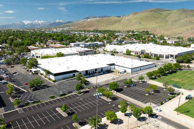
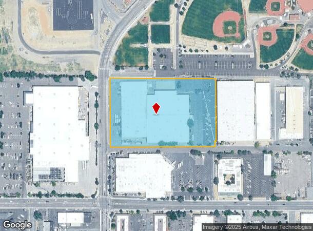
550 Mallory Way, Carson City, NV 89701
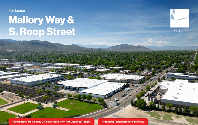
Current Lease Availabilities
NEARBY LISTINGS FOR SALE OR LEASE
Property Detail
550 Mallory Way
Carson City, NV
Parcel 1 Map #2104
009-551-28
PARCEL 1 MAP #2104
Lightindustrial
Carson City
X
Nevada
3200010094F
1
2025
5.77 AC
2025
Carson City County
000601
Reno/Sparks
119,500 SF
DEMOGRAPHICS near 550 Mallory Way
1 Mile
3 Mile
5 Mile
2024 Total Population
12,765
51,572
63,425
2029 Population
12,843
51,938
63,934
Pop Growth 2024-2029
+ 0.61%
+ 0.71%
+ 0.80%
Average Age
43
43
43
2024 Total Households
5,182
20,829
25,567
HH Growth 2024-2029
+ 0.71%
+ 0.75%
+ 0.83%
Median Household Inc
$67,634
$66,861
$69,239
Avg Household Size
2.20
2.30
2.30
2024 Avg HH Vehicles
2.00
2.00
2.00
Median Home Value
$355,038
$378,965
$395,158
Median Year Built
1978
1980
1982
Nearby Places
- Restaurants
- Banks
- Shops
- Fitness
- Groceries
PUBLIC TRANSPORTATION
AIRPORT
Reno/Tahoe International
DRIVE
WALK
Distance
Reno/Tahoe International
56 min
34.1 mi
Freight Ports
Port of Stockton
DRIVE
WALK
Distance
Port of Stockton
218 min
150.6 mi
Nearby Properties
Address
Land Use
TOTAL SIZE
Lot Size
Zoning
Address
Land Use
TOTAL SIZE
Lot Size
Zoning
351,100 SF
22.10 AC
MFA-GC
Address
Land Use
TOTAL SIZE
Lot Size
Zoning
428,691 SF
10.40 AC
P
Address
Land Use
TOTAL SIZE
Lot Size
Zoning
208,552 SF
84.87 AC
PR
Address
Land Use
TOTAL SIZE
Lot Size
Zoning
356,776 SF
64.42 AC
P
Address
Land Use
TOTAL SIZE
Lot Size
Zoning
175,233 SF
5.88 AC
PR
Address
Land Use
TOTAL SIZE
Lot Size
Zoning
1.24 AC
PR
Address
Land Use
TOTAL SIZE
Lot Size
Zoning
272,519 SF
102.35 AC
P
Address
Land Use
TOTAL SIZE
Lot Size
Zoning
144,231 SF
25.73 AC
P
Address
Land Use
TOTAL SIZE
Lot Size
Zoning
3,120 SF
6.12 AC
NB
Address
Land Use
TOTAL SIZE
Lot Size
Zoning
92,560 SF
4.93 AC
MFA
Address
Land Use
TOTAL SIZE
Lot Size
Zoning
213,246 SF
19.48 AC
GC-RC
Address
Land Use
TOTAL SIZE
Lot Size
Zoning
157,914 SF
7.15 AC
PR
Address
Land Use
TOTAL SIZE
Lot Size
Zoning
199,052 SF
7.46 AC
GC
Address
Land Use
TOTAL SIZE
Lot Size
Zoning
8,000 SF
413.63 AC
PC
Address
Land Use
TOTAL SIZE
Lot Size
Zoning
224,615 SF
21.47 AC
Address
Land Use
TOTAL SIZE
Lot Size
Zoning
109,200 SF
9.35 AC
GC
Address
Land Use
TOTAL SIZE
Lot Size
Zoning
89,408 SF
39.22 AC
P
Address
Land Use
TOTAL SIZE
Lot Size
Zoning
169,086 SF
18.49 AC
RC-P
Address
Land Use
TOTAL SIZE
Lot Size
Zoning
287,038 SF
49.20 AC
P
Address
Land Use
TOTAL SIZE
Lot Size
Zoning
116,494 SF
16.39 AC
P
Address
Land Use
TOTAL SIZE
Lot Size
Zoning
87,992 SF
4.13 AC
P
Address
Land Use
TOTAL SIZE
Lot Size
Zoning
138,001 SF
2.20 AC
P
Address
Land Use
TOTAL SIZE
Lot Size
Zoning
70,843 SF
24.29 AC
PR
Address
Land Use
TOTAL SIZE
Lot Size
Zoning
75,863 SF
3.92 AC
RC
Address
Land Use
TOTAL SIZE
Lot Size
Zoning
111,950 SF
18.20 AC
RC-MHP
Address
Land Use
TOTAL SIZE
Lot Size
Zoning
113,007 SF
52.90 AC
PR
Address
Land Use
TOTAL SIZE
Lot Size
Zoning
4,685 SF
49.08 AC
PR
Address
Land Use
TOTAL SIZE
Lot Size
Zoning
156,408 SF
2.08 AC
MFA-GC
Address
Land Use
TOTAL SIZE
Lot Size
Zoning
160 AC
PR
Address
Land Use
TOTAL SIZE
Lot Size
Zoning
125,780 SF
28.21 AC
P
The World's #1 Commercial Real Estate Marketplace
Connect with us
© 2025 CoStar Group
The information above has been obtained from sources believed reliable. While we do not doubt its accuracy we have not verified it and make no guarantee, warranty or representation about it. It is your responsibility to independently confirm its accuracy and completeness. Any projections, opinions, assumptions, or estimates used are for example only and do not represent the current or future performance of the property. The value of this transaction to you depends on tax and other factors which should be evaluated by your tax, financial, and legal advisors. You and your advisors should conduct a careful, independent investigation of the property to determine to your satisfaction the suitability of the property for your needs.