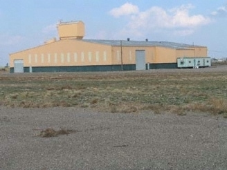
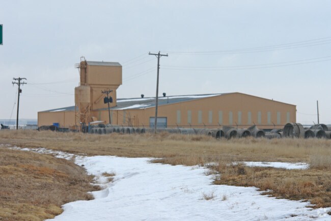
Property Record
550 N Lakeside Dr, Amarillo, TX 79118

Property Detail
550 N Lakeside Dr
Industrialgeneral
SECT 73 A B & M BLK 0002, 38.052 ACS BEG 2694.5FT N & 190.64FT E OF SW COR OF SECT, 35.8800 ACRES
I1
Potter
B and X Area of moderate flood hazard, usually the area between the limits of the 100-year and 500-year floods.
Texas
2025
35.88 AC
2025
Other Market Areas
014401
Amarillo, TX
33,588 SF
R-200-0730-0001-0
NEARBY LISTINGS FOR SALE OR LEASE
-
-
View all Amarillo listings for sale on LoopNet.com
DEMOGRAPHICS near 550 N Lakeside Dr
1 mile
3 mile
5 mile
2025 Total Population
317
13,221
47,587
2030 Population
315
13,011
46,987
Pop Growth 2025-2030
(0.63%)
(1.59%)
(1.26%)
Average Age
34
38
36
2025 Total Households
96
2,952
14,235
HH Growth 2025-2030
0.00%
(2.13%)
(1.43%)
Median Household Inc
$48,333
$43,481
$46,518
Avg Household Size
2.90
3.10
2.90
2025 Avg HH Vehicles
2.00
2.00
2.00
Median Home Value
$81,578
$99,661
$111,828
Median Year Built
1959
1961
1960
Nearby Places
Map Layers
Map Styles
 Street
 Aerial
Layers
 Traffic
 Biking
Places
Listings with unknown addresses are not visible on the map
- Restaurants
- Banks
- Shops
- Fitness
- Groceries
PUBLIC TRANSPORTATION
AIRPORT
Rick Husband Amarillo International
Drive
Walk
Distance
Rick Husband Amarillo International
12 min
5.9 mi
Freight Ports
Tulsa Port Of Catoosa
Drive
Walk
Distance
Tulsa Port Of Catoosa
392 min
372.5 mi
SALE & LEASE HISTORY
LISTING DATE
SALE/LEASE

Mar 27, 2017
For Sale
Nearby Properties
Address
Land Use
TOTAL SIZE
Lot Size
Zoning
Address
Land Use
TOTAL SIZE
Lot Size
Zoning
1,079,953 SF
106.07 AC
Address
Land Use
TOTAL SIZE
Lot Size
Zoning
729,964 SF
245.57 AC
I1
Address
Land Use
TOTAL SIZE
Lot Size
Zoning
572,685 SF
34.93 AC
Address
Land Use
TOTAL SIZE
Lot Size
Zoning
265,956 SF
48 AC
Address
Land Use
TOTAL SIZE
Lot Size
Zoning
89,206 SF
17.98 AC
Address
Land Use
TOTAL SIZE
Lot Size
Zoning
91,802 SF
7 AC
Address
Land Use
TOTAL SIZE
Lot Size
Zoning
315,634 SF
53.49 AC
Address
Land Use
TOTAL SIZE
Lot Size
Zoning
76,777 SF
17.10 AC
Address
Land Use
TOTAL SIZE
Lot Size
Zoning
152,702 SF
46.34 AC
Address
Land Use
TOTAL SIZE
Lot Size
Zoning
257,520 SF
19.81 AC
PD
Address
Land Use
TOTAL SIZE
Lot Size
Zoning
190,035 SF
13.26 AC
Address
Land Use
TOTAL SIZE
Lot Size
Zoning
136,844 SF
38.77 AC
Address
Land Use
TOTAL SIZE
Lot Size
Zoning
39,430 SF
38.42 AC
Address
Land Use
TOTAL SIZE
Lot Size
Zoning
89,740 SF
2.71 AC
Address
Land Use
TOTAL SIZE
Lot Size
Zoning
92,341 SF
9.91 AC
R3
Address
Land Use
TOTAL SIZE
Lot Size
Zoning
23.39 AC
Address
Land Use
TOTAL SIZE
Lot Size
Zoning
87,936 SF
2.89 AC
Address
Land Use
TOTAL SIZE
Lot Size
Zoning
184,345 SF
624.10 AC
I1
Address
Land Use
TOTAL SIZE
Lot Size
Zoning
66,756 SF
6.21 AC
Address
Land Use
TOTAL SIZE
Lot Size
Zoning
79,521 SF
Address
Land Use
TOTAL SIZE
Lot Size
Zoning
52,318 SF
1.78 AC
Address
Land Use
TOTAL SIZE
Lot Size
Zoning
15,448 SF
16.10 AC
Address
Land Use
TOTAL SIZE
Lot Size
Zoning
89,982 SF
9.75 AC
Address
Land Use
TOTAL SIZE
Lot Size
Zoning
58,977 SF
25.27 AC
PD
Address
Land Use
TOTAL SIZE
Lot Size
Zoning
53,855 SF
1.88 AC
HC
Address
Land Use
TOTAL SIZE
Lot Size
Zoning
65,730 SF
9.09 AC
A
Address
Land Use
TOTAL SIZE
Lot Size
Zoning
84,352 SF
21.76 AC
HC
Address
Land Use
TOTAL SIZE
Lot Size
Zoning
73,196 SF
Address
Land Use
TOTAL SIZE
Lot Size
Zoning
133,029 SF
154.15 AC
I1
Address
Land Use
TOTAL SIZE
Lot Size
Zoning
57,981 SF
9.55 AC
R3
The World's #1 Commercial Real Estate Marketplace
Connect with us
© 2026 CoStar Group
The information above has been obtained from sources believed reliable. While we do not doubt its accuracy we have not verified it and make no guarantee, warranty or representation about it. It is your responsibility to independently confirm its accuracy and completeness. Any projections, opinions, assumptions, or estimates used are for example only and do not represent the current or future performance of the property. The value of this transaction to you depends on tax and other factors which should be evaluated by your tax, financial, and legal advisors. You and your advisors should conduct a careful, independent investigation of the property to determine to your satisfaction the suitability of the property for your needs.