Property Record
550 N Washington St, Round Top, TX 78954
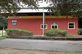

Property Detail
550 N Washington St
R51947
CITY OF ROUND TOP ACREAGE 4.472 COMM - THE STONE CELLAR
Commercialnec
FAYETTE
B and X Area of moderate flood hazard, usually the area between the limits of the 100-year and 500-year floods.
Texas
2025
4.47 AC
2025
Central Texas Area
970100
Other Market Areas
18,631 SF
NEARBY LISTINGS FOR SALE OR LEASE
-
-
View all Round Top listings for sale on LoopNet.com
DEMOGRAPHICS near 550 N Washington St
1 mile
3 mile
5 mile
2025 Total Population
223
603
1,295
2030 Population
237
638
1,357
Pop Growth 2025-2030
+ 6.28%
+ 5.80%
+ 4.79%
Average Age
54
53
51
2025 Total Households
105
282
595
HH Growth 2025-2030
+ 6.67%
+ 5.67%
+ 4.71%
Median Household Inc
$82,143
$86,184
$92,129
Avg Household Size
2.10
2.10
2.20
2025 Avg HH Vehicles
3.00
3.00
3.00
Median Home Value
$673,611
$637,097
$498,360
Median Year Built
1995
1992
1987
Nearby Places
Map Layers
Map Styles
 Street
 Aerial
Layers
 Traffic
 Biking
Places
Listings with unknown addresses are not visible on the map
- Restaurants
- Banks
- Shops
- Fitness
- Groceries
Nearby Properties
Address
Land Use
TOTAL SIZE
Lot Size
Zoning
Address
Land Use
TOTAL SIZE
Lot Size
Zoning
8,412 SF
292.33 AC
Address
Land Use
TOTAL SIZE
Lot Size
Zoning
2,890 SF
216.05 AC
Address
Land Use
TOTAL SIZE
Lot Size
Zoning
5,488 SF
172.57 AC
Address
Land Use
TOTAL SIZE
Lot Size
Zoning
3,800 SF
148.34 AC
Address
Land Use
TOTAL SIZE
Lot Size
Zoning
1,904 SF
190.55 AC
Address
Land Use
TOTAL SIZE
Lot Size
Zoning
5,400 SF
140 AC
Address
Land Use
TOTAL SIZE
Lot Size
Zoning
2,821 SF
238.19 AC
Address
Land Use
TOTAL SIZE
Lot Size
Zoning
15,606 SF
86.78 AC
Address
Land Use
TOTAL SIZE
Lot Size
Zoning
1,362 SF
139.64 AC
Address
Land Use
TOTAL SIZE
Lot Size
Zoning
1,324 SF
138.38 AC
Address
Land Use
TOTAL SIZE
Lot Size
Zoning
150 AC
Address
Land Use
TOTAL SIZE
Lot Size
Zoning
1,872 SF
44.04 AC
Address
Land Use
TOTAL SIZE
Lot Size
Zoning
4,444 SF
96.86 AC
Address
Land Use
TOTAL SIZE
Lot Size
Zoning
2,462 SF
85.07 AC
Address
Land Use
TOTAL SIZE
Lot Size
Zoning
2,016 SF
93.10 AC
Address
Land Use
TOTAL SIZE
Lot Size
Zoning
3,485 SF
88.87 AC
Address
Land Use
TOTAL SIZE
Lot Size
Zoning
260 SF
40.31 AC
Address
Land Use
TOTAL SIZE
Lot Size
Zoning
1,080 SF
76.25 AC
Address
Land Use
TOTAL SIZE
Lot Size
Zoning
1,954 SF
72.77 AC
Address
Land Use
TOTAL SIZE
Lot Size
Zoning
6,593 SF
115.82 AC
Address
Land Use
TOTAL SIZE
Lot Size
Zoning
120 SF
74.51 AC
Address
Land Use
TOTAL SIZE
Lot Size
Zoning
3,578 SF
101.25 AC
Address
Land Use
TOTAL SIZE
Lot Size
Zoning
1,596 SF
89.36 AC
Address
Land Use
TOTAL SIZE
Lot Size
Zoning
35,929 SF
11.76 AC
Address
Land Use
TOTAL SIZE
Lot Size
Zoning
1,260 SF
96.16 AC
Address
Land Use
TOTAL SIZE
Lot Size
Zoning
1,092 SF
70.08 AC
Address
Land Use
TOTAL SIZE
Lot Size
Zoning
768 SF
101.64 AC
Address
Land Use
TOTAL SIZE
Lot Size
Zoning
168 SF
97.50 AC
Address
Land Use
TOTAL SIZE
Lot Size
Zoning
53,971 SF
16.49 AC
Address
Land Use
TOTAL SIZE
Lot Size
Zoning
4,148 SF
57.22 AC
The World's #1 Commercial Real Estate Marketplace
Connect with us
© 2026 CoStar Group
The information above has been obtained from sources believed reliable. While we do not doubt its accuracy we have not verified it and make no guarantee, warranty or representation about it. It is your responsibility to independently confirm its accuracy and completeness. Any projections, opinions, assumptions, or estimates used are for example only and do not represent the current or future performance of the property. The value of this transaction to you depends on tax and other factors which should be evaluated by your tax, financial, and legal advisors. You and your advisors should conduct a careful, independent investigation of the property to determine to your satisfaction the suitability of the property for your needs.