Property Record
550 Sugar Mill Rd, Oviedo, FL 32765

NEARBY LISTINGS FOR SALE OR LEASE
-
-
View all Oviedo listings for sale on LoopNet.com
Property Detail
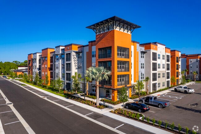
550 Sugar Mill Rd
Orlando
Dwell At Oviedo
Orlando-Kissimmee-Sanford, FL
LOT 4 DWELL AT OVIEDO PLAT BOOK 89 PAGES 18-20
16-21-31-525-0000-0040
Seminole
Multifamilydwelling
Florida
2025
4
2025
4.07 AC
021314
Downtown Oviedo
DEMOGRAPHICS near 550 Sugar Mill Rd
1 mile
3 mile
5 mile
2024 Total Population
3,492
62,707
153,725
2029 Population
3,601
65,029
158,885
Pop Growth 2024-2029
+ 3.12%
+ 3.70%
+ 3.36%
Average Age
42
40
39
2024 Total Households
1,255
22,694
53,803
HH Growth 2024-2029
+ 3.27%
+ 3.80%
+ 3.41%
Median Household Inc
$73,892
$94,210
$85,024
Avg Household Size
2.70
2.70
2.60
2024 Avg HH Vehicles
2.00
2.00
2.00
Median Home Value
$396,332
$375,610
$358,332
Median Year Built
1988
1992
1992
Nearby Places
Map Layers
Map Styles
 Street
 Aerial
Transit
 Traffic
 Biking
Places
Listings with unknown addresses are not visible on the map
- Restaurants
- Banks
- Shops
- Fitness
- Groceries
PUBLIC TRANSPORTATION
COMMUTER RAIL
Drive
Walk
Distance
18 min
9.5 mi
AIRPORT
Orlando Sanford International
Drive
Walk
Distance
Orlando Sanford International
19 min
12.3 mi
Orlando International
Drive
Walk
Distance
Orlando International
32 min
24.2 mi
Freight Ports
Port Canaveral
Drive
Walk
Distance
Port Canaveral
69 min
57.2 mi
Nearby Properties
Address
Land Use
TOTAL SIZE
Lot Size
Zoning
Address
Land Use
TOTAL SIZE
Lot Size
Zoning
581 SF
29.77 AC
Address
Land Use
TOTAL SIZE
Lot Size
Zoning
276,300 SF
3.34 AC
A1
Address
Land Use
TOTAL SIZE
Lot Size
Zoning
5,938 SF
9.14 AC
Address
Land Use
TOTAL SIZE
Lot Size
Zoning
3,406 SF
29.43 AC
PUD
Address
Land Use
TOTAL SIZE
Lot Size
Zoning
183,886 SF
47.67 AC
A1
Address
Land Use
TOTAL SIZE
Lot Size
Zoning
6,321 SF
40.84 AC
Address
Land Use
TOTAL SIZE
Lot Size
Zoning
432 SF
16.07 AC
PUD
Address
Land Use
TOTAL SIZE
Lot Size
Zoning
792 SF
15.23 AC
PUD
Address
Land Use
TOTAL SIZE
Lot Size
Zoning
9.23 AC
Address
Land Use
TOTAL SIZE
Lot Size
Zoning
98,868 SF
3.02 AC
Address
Land Use
TOTAL SIZE
Lot Size
Zoning
4,380 SF
20.01 AC
A1
Address
Land Use
TOTAL SIZE
Lot Size
Zoning
906 SF
15.85 AC
C1
Address
Land Use
TOTAL SIZE
Lot Size
Zoning
25,480 SF
23.86 AC
PUD
Address
Land Use
TOTAL SIZE
Lot Size
Zoning
412,265 SF
52.13 AC
PLI
Address
Land Use
TOTAL SIZE
Lot Size
Zoning
10,500 SF
21.76 AC
PUD
Address
Land Use
TOTAL SIZE
Lot Size
Zoning
203,683 SF
8.82 AC
R4
Address
Land Use
TOTAL SIZE
Lot Size
Zoning
193,990 SF
27.51 AC
C2
Address
Land Use
TOTAL SIZE
Lot Size
Zoning
114,222 SF
260 AC
A1
Address
Land Use
TOTAL SIZE
Lot Size
Zoning
141,356 SF
5.07 AC
Address
Land Use
TOTAL SIZE
Lot Size
Zoning
158,927 SF
5.41 AC
MUDSF
Address
Land Use
TOTAL SIZE
Lot Size
Zoning
193,241 SF
25.77 AC
R3A
Address
Land Use
TOTAL SIZE
Lot Size
Zoning
165,650 SF
11.12 AC
M1A
Address
Land Use
TOTAL SIZE
Lot Size
Zoning
144,594 SF
19.94 AC
R3A
Address
Land Use
TOTAL SIZE
Lot Size
Zoning
10,640 SF
9.46 AC
C1
Address
Land Use
TOTAL SIZE
Lot Size
Zoning
88,181 SF
9.62 AC
C1
Address
Land Use
TOTAL SIZE
Lot Size
Zoning
178,855 SF
34.08 AC
PUD
Address
Land Use
TOTAL SIZE
Lot Size
Zoning
280,330 SF
14.77 AC
MUDNDD
Address
Land Use
TOTAL SIZE
Lot Size
Zoning
586,237 SF
43.13 AC
Address
Land Use
TOTAL SIZE
Lot Size
Zoning
8,932 SF
8.75 AC
C1
Address
Land Use
TOTAL SIZE
Lot Size
Zoning
121,389 SF
30.79 AC
A1
The World's #1 Commercial Real Estate Marketplace
Connect with us
© 2026 CoStar Group
The information above has been obtained from sources believed reliable. While we do not doubt its accuracy we have not verified it and make no guarantee, warranty or representation about it. It is your responsibility to independently confirm its accuracy and completeness. Any projections, opinions, assumptions, or estimates used are for example only and do not represent the current or future performance of the property. The value of this transaction to you depends on tax and other factors which should be evaluated by your tax, financial, and legal advisors. You and your advisors should conduct a careful, independent investigation of the property to determine to your satisfaction the suitability of the property for your needs.