Property Record
550 W Florence St, Broken Arrow, OK 74011


NEARBY LISTINGS FOR SALE OR LEASE
Property Detail
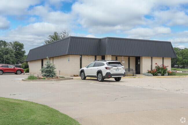
550 W Florence St
Tulsa, OK
Arrow Springs Third
78230-84-26-32170
W100 S200 LT 3 LESS S20 THEREOF FOR RD BLK 4
Medicalbuilding
Tulsa
X
Oklahoma
40143C0393M
3
2025
0.41 AC
2025
Southeast Tulsa
007511
Tulsa
3,883 SF
DEMOGRAPHICS near 550 W Florence St
1 Mile
3 Mile
5 Mile
2024 Total Population
9,805
53,748
112,988
2029 Population
10,272
56,884
121,990
Pop Growth 2024-2029
+ 4.76%
+ 5.83%
+ 7.97%
Average Age
38
39
39
2024 Total Households
3,862
20,197
42,033
HH Growth 2024-2029
+ 4.89%
+ 5.90%
+ 7.90%
Median Household Inc
$80,057
$86,815
$88,955
Avg Household Size
2.50
2.60
2.60
2024 Avg HH Vehicles
2.00
2.00
2.00
Median Home Value
$216,525
$253,077
$264,378
Median Year Built
1985
1986
1990
Nearby Places
Map Layers
Map Styles
 Street
 Aerial
- Restaurants
- Banks
- Shops
- Fitness
- Groceries
PUBLIC TRANSPORTATION
AIRPORT
Tulsa International
DRIVE
WALK
Distance
Tulsa International
31 min
21.4 mi
Freight Ports
DRIVE
WALK
Distance
30 min
23.4 mi
Nearby Properties
Address
Land Use
TOTAL SIZE
Lot Size
Zoning
Address
Land Use
TOTAL SIZE
Lot Size
Zoning
390,154 SF
52.94 AC
A1
Address
Land Use
TOTAL SIZE
Lot Size
Zoning
90,533 SF
29.41 AC
A1
Address
Land Use
TOTAL SIZE
Lot Size
Zoning
37.23 AC
A1
Address
Land Use
TOTAL SIZE
Lot Size
Zoning
21,301 SF
3.94 AC
CN
Address
Land Use
TOTAL SIZE
Lot Size
Zoning
84,314 SF
12.05 AC
A1
Address
Land Use
TOTAL SIZE
Lot Size
Zoning
68,478 SF
9.27 AC
R1
Address
Land Use
TOTAL SIZE
Lot Size
Zoning
35,954 SF
27.97 AC
CN
Address
Land Use
TOTAL SIZE
Lot Size
Zoning
67,490 SF
5.40 AC
RM
Address
Land Use
TOTAL SIZE
Lot Size
Zoning
67,149 SF
28.56 AC
R2
Address
Land Use
TOTAL SIZE
Lot Size
Zoning
Address
Land Use
TOTAL SIZE
Lot Size
Zoning
39,733 SF
9.36 AC
A1
Address
Land Use
TOTAL SIZE
Lot Size
Zoning
11,601 SF
38.18 AC
RS1
Address
Land Use
TOTAL SIZE
Lot Size
Zoning
55,185 SF
4.83 AC
NCU
Address
Land Use
TOTAL SIZE
Lot Size
Zoning
71,143 SF
4.43 AC
R1
Address
Land Use
TOTAL SIZE
Lot Size
Zoning
245,436 SF
12.21 AC
RM
Address
Land Use
TOTAL SIZE
Lot Size
Zoning
33,669 SF
4.64 AC
A1
Address
Land Use
TOTAL SIZE
Lot Size
Zoning
23,283 SF
3.94 AC
A1
Address
Land Use
TOTAL SIZE
Lot Size
Zoning
28,303 SF
16.76 AC
CN
Address
Land Use
TOTAL SIZE
Lot Size
Zoning
3,300 SF
40 AC
A1
Address
Land Use
TOTAL SIZE
Lot Size
Zoning
11,800 SF
2.45 AC
A1
Address
Land Use
TOTAL SIZE
Lot Size
Zoning
12,497 SF
3.31 AC
R1
Address
Land Use
TOTAL SIZE
Lot Size
Zoning
222,536 SF
11.31 AC
CN
Address
Land Use
TOTAL SIZE
Lot Size
Zoning
28,226 SF
8.26 AC
CN
Address
Land Use
TOTAL SIZE
Lot Size
Zoning
136,434 SF
19.20 AC
Address
Land Use
TOTAL SIZE
Lot Size
Zoning
30,482 SF
4.43 AC
R1
Address
Land Use
TOTAL SIZE
Lot Size
Zoning
27,531 SF
4.46 AC
R2
Address
Land Use
TOTAL SIZE
Lot Size
Zoning
33,004 SF
3.23 AC
R2
Address
Land Use
TOTAL SIZE
Lot Size
Zoning
11,261 SF
2.85 AC
CN
Address
Land Use
TOTAL SIZE
Lot Size
Zoning
Address
Land Use
TOTAL SIZE
Lot Size
Zoning
279,632 SF
14.54 AC
RM
The World's #1 Commercial Real Estate Marketplace
Connect with us
© 2025 CoStar Group
The information above has been obtained from sources believed reliable. While we do not doubt its accuracy we have not verified it and make no guarantee, warranty or representation about it. It is your responsibility to independently confirm its accuracy and completeness. Any projections, opinions, assumptions, or estimates used are for example only and do not represent the current or future performance of the property. The value of this transaction to you depends on tax and other factors which should be evaluated by your tax, financial, and legal advisors. You and your advisors should conduct a careful, independent investigation of the property to determine to your satisfaction the suitability of the property for your needs.