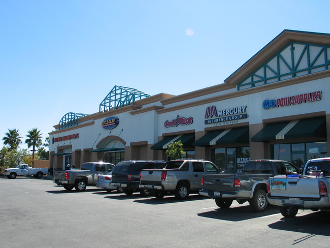
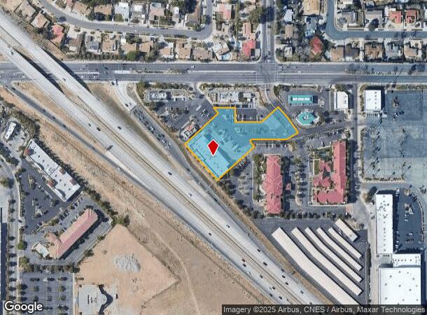
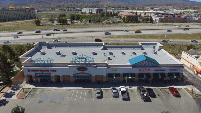
Property Record
550 E Rancho Vista Blvd, Palmdale, CA 93550

NEARBY LISTINGS FOR SALE OR LEASE
Property Detail
550 E Rancho Vista Blvd
Los Angeles-Long Beach-Glendale, CA
City Of Palmdale
3006-026-027
P M 301-94-95 LOT 3
Storemultistory
Los Angeles
X
California
06037C0657F
3
2024
1.81 AC
2025
Antelope Valley
911100
Los Angeles
14,790 SF
DEMOGRAPHICS near 550 E Rancho Vista Blvd
1 Mile
3 Mile
5 Mile
2024 Total Population
5,002
56,154
133,233
2029 Population
4,820
54,476
129,439
Pop Growth 2024-2029
(3.64%)
(2.99%)
(2.85%)
Average Age
39
36
37
2024 Total Households
1,601
17,199
41,118
HH Growth 2024-2029
(3.94%)
(3.19%)
(2.95%)
Median Household Inc
$74,835
$64,605
$67,001
Avg Household Size
3.00
3.20
3.20
2024 Avg HH Vehicles
2.00
2.00
2.00
Median Home Value
$369,594
$385,276
$361,204
Median Year Built
1984
1985
1986
Nearby Places
Map Layers
Map Styles
 Street
 Aerial
- Restaurants
- Banks
- Shops
- Fitness
- Groceries
PUBLIC TRANSPORTATION
COMMUTER RAIL
Palmdale (Antelope Valley Line - Southern California Regional Rail Authority (Metrolink))
DRIVE
WALK
Distance
Palmdale (Antelope Valley Line - Southern California Regional Rail Authority (Metrolink))
5 min
2.4 mi
Lancaster (Antelope Valley Line - Southern California Regional Rail Authority (Metrolink))
DRIVE
WALK
Distance
Lancaster (Antelope Valley Line - Southern California Regional Rail Authority (Metrolink))
13 min
7.7 mi
SALE & LEASE HISTORY
LISTING DATE
SALE/LEASE

Sep 25, 2016
For Lease
Nov 19, 2018
For Lease
Feb 06, 2018
For Sale
Apr 03, 2023
For Lease
Nearby Properties
Address
Land Use
TOTAL SIZE
Lot Size
Zoning
Address
Land Use
TOTAL SIZE
Lot Size
Zoning
2,861,890 SF
528.69 AC
POMA-A25*
Address
Land Use
TOTAL SIZE
Lot Size
Zoning
358,828 SF
26.23 AC
PDR17000
Address
Land Use
TOTAL SIZE
Lot Size
Zoning
449,135 SF
29.76 AC
PDRA
Address
Land Use
TOTAL SIZE
Lot Size
Zoning
130,392 SF
26.91 AC
PDCPD*
Address
Land Use
TOTAL SIZE
Lot Size
Zoning
201,615 SF
20.60 AC
PDC4
Address
Land Use
TOTAL SIZE
Lot Size
Zoning
88,750 SF
9.28 AC
PDM1 1/2*
Address
Land Use
TOTAL SIZE
Lot Size
Zoning
66,526 SF
9.12 AC
LAWC
Address
Land Use
TOTAL SIZE
Lot Size
Zoning
128,353 SF
9.49 AC
PDCPD-R1*
Address
Land Use
TOTAL SIZE
Lot Size
Zoning
50,735 SF
PDCPD
Address
Land Use
TOTAL SIZE
Lot Size
Zoning
78,492 SF
3.25 AC
PDCPD
Address
Land Use
TOTAL SIZE
Lot Size
Zoning
139,513 SF
4.07 AC
PDCPD
Address
Land Use
TOTAL SIZE
Lot Size
Zoning
60,644 SF
3.89 AC
PDMX*
Address
Land Use
TOTAL SIZE
Lot Size
Zoning
103,503 SF
3.61 AC
PDC2
Address
Land Use
TOTAL SIZE
Lot Size
Zoning
64,818 SF
2.30 AC
PDCP
Address
Land Use
TOTAL SIZE
Lot Size
Zoning
57,382 SF
2.52 AC
PDC4*
Address
Land Use
TOTAL SIZE
Lot Size
Zoning
59,577 SF
0.59 AC
PDR17000
Address
Land Use
TOTAL SIZE
Lot Size
Zoning
69,555 SF
7.55 AC
PDMPD*
Address
Land Use
TOTAL SIZE
Lot Size
Zoning
147,297 SF
10.57 AC
POC4
Address
Land Use
TOTAL SIZE
Lot Size
Zoning
68,943 SF
2.72 AC
POC4
Address
Land Use
TOTAL SIZE
Lot Size
Zoning
71,394 SF
2.93 AC
PDCPD*
Address
Land Use
TOTAL SIZE
Lot Size
Zoning
115,684 SF
10.46 AC
PDRA
Address
Land Use
TOTAL SIZE
Lot Size
Zoning
36,033 SF
3.81 AC
PDMPD*
Address
Land Use
TOTAL SIZE
Lot Size
Zoning
Address
Land Use
TOTAL SIZE
Lot Size
Zoning
144,471 SF
12.96 AC
PDCPD-MPD*
Address
Land Use
TOTAL SIZE
Lot Size
Zoning
80,981 SF
7.11 AC
PDC3
Address
Land Use
TOTAL SIZE
Lot Size
Zoning
155,364 SF
15.42 AC
PDC4
Address
Land Use
TOTAL SIZE
Lot Size
Zoning
55,079 SF
1.98 AC
PDCPD*
Address
Land Use
TOTAL SIZE
Lot Size
Zoning
57,416 SF
10.11 AC
PDA12 1/2*
Address
Land Use
TOTAL SIZE
Lot Size
Zoning
71,974 SF
3.83 AC
PDCPD*
The World's #1 Commercial Real Estate Marketplace
Connect with us
© 2025 CoStar Group
The information above has been obtained from sources believed reliable. While we do not doubt its accuracy we have not verified it and make no guarantee, warranty or representation about it. It is your responsibility to independently confirm its accuracy and completeness. Any projections, opinions, assumptions, or estimates used are for example only and do not represent the current or future performance of the property. The value of this transaction to you depends on tax and other factors which should be evaluated by your tax, financial, and legal advisors. You and your advisors should conduct a careful, independent investigation of the property to determine to your satisfaction the suitability of the property for your needs.