Property Record
550 W State Highway 114, Grapevine, TX 76051
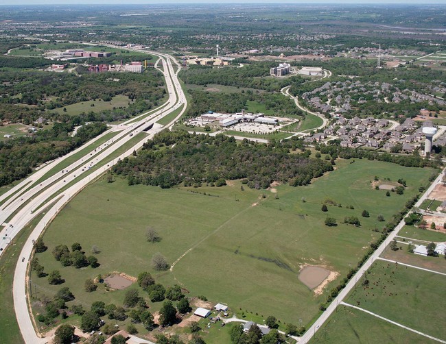
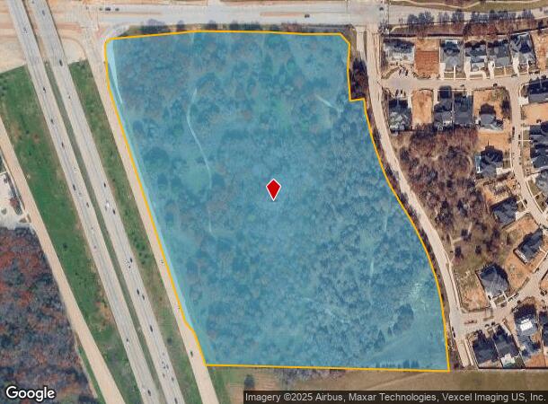
This Property Is For Sale
NEARBY LISTINGS FOR SALE OR LEASE
Property Detail
550 W State Highway 114
Dallas-Fort Worth-Arlington, TX
West, James J Survey
41248848
WEST, JAMES J SURVEY ABSTRACT 1620 TRACT 1F
Residentialacreage
Tarrant
X
Texas
48121C0660G
25.14 AC
2024
Westlake/Grapevine
2025
Dallas/Ft Worth
113712
DEMOGRAPHICS near 550 W State Highway 114
1 Mile
3 Mile
5 Mile
2024 Total Population
3,841
38,312
116,969
2029 Population
4,047
41,229
126,943
Pop Growth 2024-2029
+ 5.36%
+ 7.61%
+ 8.53%
Average Age
38
40
40
2024 Total Households
1,129
12,229
39,845
HH Growth 2024-2029
+ 5.40%
+ 8.00%
+ 8.72%
Median Household Inc
$238,802
$208,802
$156,486
Avg Household Size
3.40
3.10
2.90
2024 Avg HH Vehicles
3.00
2.00
2.00
Median Home Value
$925,511
$745,453
$629,081
Median Year Built
1998
1994
1995
Nearby Places
Map Layers
Map Styles
 Street
 Aerial
- Restaurants
- Banks
- Shops
- Fitness
- Groceries
PUBLIC TRANSPORTATION
AIRPORT
Dallas-Fort Worth International
DRIVE
WALK
Distance
Dallas-Fort Worth International
15 min
11.2 mi
Dallas Love Field
DRIVE
WALK
Distance
Dallas Love Field
34 min
24.9 mi
Freight Ports
Port of Shreveport
DRIVE
WALK
Distance
Port of Shreveport
243 min
224.8 mi
Nearby Properties
Address
Land Use
TOTAL SIZE
Lot Size
Zoning
Address
Land Use
TOTAL SIZE
Lot Size
Zoning
255,937 SF
55.03 AC
Address
Land Use
TOTAL SIZE
Lot Size
Zoning
254,250 SF
6.21 AC
Address
Land Use
TOTAL SIZE
Lot Size
Zoning
1,603,686 SF
81.43 AC
Address
Land Use
TOTAL SIZE
Lot Size
Zoning
203,458 SF
16.58 AC
Address
Land Use
TOTAL SIZE
Lot Size
Zoning
1,872,003 SF
52.16 AC
Address
Land Use
TOTAL SIZE
Lot Size
Zoning
1,420,661 SF
40.78 AC
Address
Land Use
TOTAL SIZE
Lot Size
Zoning
314,692 SF
78.63 AC
Address
Land Use
TOTAL SIZE
Lot Size
Zoning
645,587 SF
12.57 AC
Address
Land Use
TOTAL SIZE
Lot Size
Zoning
242,000 SF
3.72 AC
Address
Land Use
TOTAL SIZE
Lot Size
Zoning
261,466 SF
6.83 AC
Address
Land Use
TOTAL SIZE
Lot Size
Zoning
196,350 SF
12.05 AC
Address
Land Use
TOTAL SIZE
Lot Size
Zoning
306,052 SF
1.92 AC
Address
Land Use
TOTAL SIZE
Lot Size
Zoning
191,001 SF
17.58 AC
Address
Land Use
TOTAL SIZE
Lot Size
Zoning
89,500 SF
8.47 AC
Address
Land Use
TOTAL SIZE
Lot Size
Zoning
597,855 SF
Address
Land Use
TOTAL SIZE
Lot Size
Zoning
136,358 SF
16.51 AC
Address
Land Use
TOTAL SIZE
Lot Size
Zoning
1,188,418 SF
20.15 AC
Address
Land Use
TOTAL SIZE
Lot Size
Zoning
219,109 SF
24.78 AC
Address
Land Use
TOTAL SIZE
Lot Size
Zoning
122,466 SF
43.83 AC
Address
Land Use
TOTAL SIZE
Lot Size
Zoning
143,500 SF
1.79 AC
Address
Land Use
TOTAL SIZE
Lot Size
Zoning
121,348 SF
13.78 AC
Address
Land Use
TOTAL SIZE
Lot Size
Zoning
188,500 SF
6.28 AC
Address
Land Use
TOTAL SIZE
Lot Size
Zoning
155,000 SF
24.66 AC
Address
Land Use
TOTAL SIZE
Lot Size
Zoning
133,430 SF
19.75 AC
Address
Land Use
TOTAL SIZE
Lot Size
Zoning
153.50 AC
Address
Land Use
TOTAL SIZE
Lot Size
Zoning
317,920 SF
3.42 AC
Address
Land Use
TOTAL SIZE
Lot Size
Zoning
346,672 SF
2.41 AC
Address
Land Use
TOTAL SIZE
Lot Size
Zoning
63,146 SF
8.72 AC
Address
Land Use
TOTAL SIZE
Lot Size
Zoning
25,965 SF
79.42 AC
Address
Land Use
TOTAL SIZE
Lot Size
Zoning
450,116 SF
83.06 AC
The World's #1 Commercial Real Estate Marketplace
Connect with us
© 2026 CoStar Group
The information above has been obtained from sources believed reliable. While we do not doubt its accuracy we have not verified it and make no guarantee, warranty or representation about it. It is your responsibility to independently confirm its accuracy and completeness. Any projections, opinions, assumptions, or estimates used are for example only and do not represent the current or future performance of the property. The value of this transaction to you depends on tax and other factors which should be evaluated by your tax, financial, and legal advisors. You and your advisors should conduct a careful, independent investigation of the property to determine to your satisfaction the suitability of the property for your needs.