Property Record
5500 4Th St W, Lehigh Acres, FL 33971

NEARBY LISTINGS FOR SALE OR LEASE
Property Detail
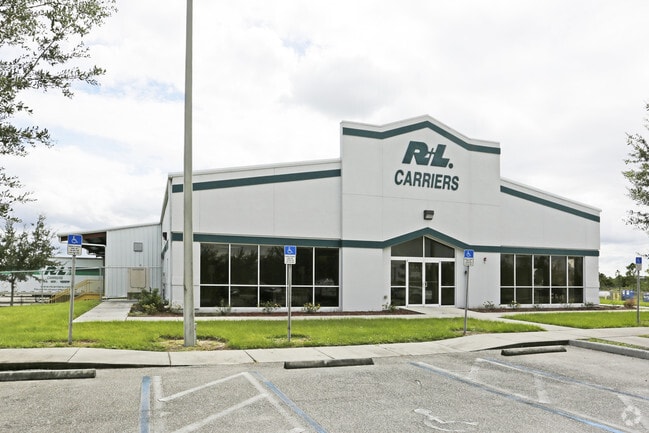
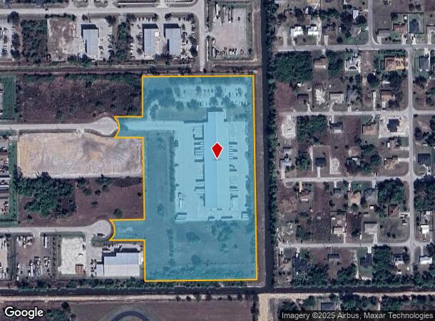
5500 4Th St W
Cape Coral-Fort Myers, FL
Lehigh Estates
30-44-26-00-00001.0160
VAC R/W CANALS + BLKS LEHIGH EST UNIT 1 DESC OR 4324 PG 3233
Warehouse
Lee
X
Florida
12071C0475F
c
2025
13.23 AC
2025
Lehigh
040127
Southwest Florida
53,960 SF
DEMOGRAPHICS near 5500 4Th St W
1 Mile
3 Mile
5 Mile
2024 Total Population
7,018
45,460
99,243
2029 Population
8,168
53,511
118,019
Pop Growth 2024-2029
+ 16.39%
+ 17.71%
+ 18.92%
Average Age
33
38
40
2024 Total Households
2,103
15,416
35,419
HH Growth 2024-2029
+ 15.93%
+ 17.48%
+ 19.06%
Median Household Inc
$54,355
$68,261
$69,680
Avg Household Size
3.20
2.80
2.60
2024 Avg HH Vehicles
2.00
2.00
2.00
Median Home Value
$244,850
$279,144
$280,457
Median Year Built
2003
2004
2006
Nearby Places
Map Layers
Map Styles
 Street
 Aerial
- Restaurants
- Banks
- Shops
- Fitness
- Groceries
PUBLIC TRANSPORTATION
AIRPORT
Southwest Florida International
DRIVE
WALK
Distance
Southwest Florida International
17 min
7.5 mi
Punta Gorda
DRIVE
WALK
Distance
Punta Gorda
38 min
29.4 mi
Freight Ports
Port Manatee
DRIVE
WALK
Distance
Port Manatee
118 min
101.1 mi
Nearby Properties
Address
Land Use
TOTAL SIZE
Lot Size
Zoning
Address
Land Use
TOTAL SIZE
Lot Size
Zoning
24.69 AC
C-1
Address
Land Use
TOTAL SIZE
Lot Size
Zoning
519,706 SF
95.18 AC
RS-1
Address
Land Use
TOTAL SIZE
Lot Size
Zoning
111.70 AC
C1
Address
Land Use
TOTAL SIZE
Lot Size
Zoning
17.50 AC
C1
Address
Land Use
TOTAL SIZE
Lot Size
Zoning
333,614 SF
294.30 AC
AG-2
Address
Land Use
TOTAL SIZE
Lot Size
Zoning
135,503 SF
15.29 AC
AG-2
Address
Land Use
TOTAL SIZE
Lot Size
Zoning
68.11 AC
PUD
Address
Land Use
TOTAL SIZE
Lot Size
Zoning
75,477 SF
13.12 AC
SDA
Address
Land Use
TOTAL SIZE
Lot Size
Zoning
29.75 AC
CI
Address
Land Use
TOTAL SIZE
Lot Size
Zoning
85,812 SF
15.76 AC
PUD
Address
Land Use
TOTAL SIZE
Lot Size
Zoning
95,220 SF
3.23 AC
SDA
Address
Land Use
TOTAL SIZE
Lot Size
Zoning
2.10 AC
C1
Address
Land Use
TOTAL SIZE
Lot Size
Zoning
106,286 SF
16.57 AC
PUD
Address
Land Use
TOTAL SIZE
Lot Size
Zoning
142,693 SF
5.97 AC
C-2
Address
Land Use
TOTAL SIZE
Lot Size
Zoning
43,676 SF
10.48 AC
CF-2
Address
Land Use
TOTAL SIZE
Lot Size
Zoning
35,579 SF
8.06 AC
SDA
Address
Land Use
TOTAL SIZE
Lot Size
Zoning
108,797 SF
7.39 AC
IL
Address
Land Use
TOTAL SIZE
Lot Size
Zoning
35,974 SF
3.16 AC
IL
Address
Land Use
TOTAL SIZE
Lot Size
Zoning
70,622 SF
2.17 AC
CPD
Address
Land Use
TOTAL SIZE
Lot Size
Zoning
76,999 SF
34.31 AC
C-2
Address
Land Use
TOTAL SIZE
Lot Size
Zoning
11.76 AC
SDA
Address
Land Use
TOTAL SIZE
Lot Size
Zoning
6,710 SF
1.24 AC
SDA
Address
Land Use
TOTAL SIZE
Lot Size
Zoning
35,087 SF
3.34 AC
MU
Address
Land Use
TOTAL SIZE
Lot Size
Zoning
13,953 SF
2.43 AC
MU
Address
Land Use
TOTAL SIZE
Lot Size
Zoning
22,254 SF
2.35 AC
IL
Address
Land Use
TOTAL SIZE
Lot Size
Zoning
56,183 SF
221.30 AC
PUD
Address
Land Use
TOTAL SIZE
Lot Size
Zoning
19,085 SF
7.30 AC
PUD
Address
Land Use
TOTAL SIZE
Lot Size
Zoning
27,521 SF
3.26 AC
CPD
Address
Land Use
TOTAL SIZE
Lot Size
Zoning
20,220 SF
9.67 AC
CF
Address
Land Use
TOTAL SIZE
Lot Size
Zoning
18,144 SF
1.60 AC
PUD
The World's #1 Commercial Real Estate Marketplace
Connect with us
© 2026 CoStar Group
The information above has been obtained from sources believed reliable. While we do not doubt its accuracy we have not verified it and make no guarantee, warranty or representation about it. It is your responsibility to independently confirm its accuracy and completeness. Any projections, opinions, assumptions, or estimates used are for example only and do not represent the current or future performance of the property. The value of this transaction to you depends on tax and other factors which should be evaluated by your tax, financial, and legal advisors. You and your advisors should conduct a careful, independent investigation of the property to determine to your satisfaction the suitability of the property for your needs.