Property Record
Garcon Shores Dr, Milton, FL 32583
NEARBY LISTINGS FOR SALE OR LEASE
Property Detail
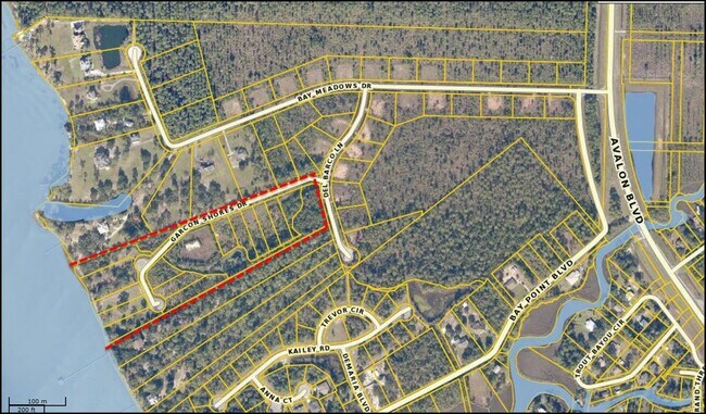
Garcon Shores Dr
Pensacola-Ferry Pass-Brent, FL
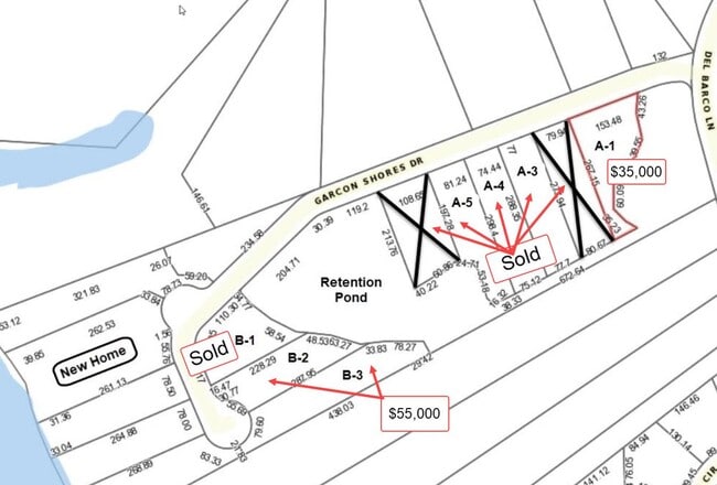
Garcon Shores
10-1S-28-1293-00A00-0030
GARCON SHORES LOT 3 BLK A AS DES IN OR 4384 PG 46
Vacantlandnec
Santa Rosa
AE
Florida
12113C0440H
3
2024
0.50 AC
2025
Avalon Beach/Milton
010709
Pensacola
DEMOGRAPHICS near Garcon Shores Dr
1 Mile
3 Mile
5 Mile
2024 Total Population
507
3,958
17,623
2029 Population
591
4,596
19,256
Pop Growth 2024-2029
+ 16.57%
+ 16.12%
+ 9.27%
Average Age
46
44
42
2024 Total Households
200
1,559
7,229
HH Growth 2024-2029
+ 17.00%
+ 16.48%
+ 9.01%
Median Household Inc
$86,184
$92,215
$80,172
Avg Household Size
2.60
2.50
2.40
2024 Avg HH Vehicles
2.00
2.00
2.00
Median Home Value
$321,795
$299,755
$247,457
Median Year Built
1996
2001
1987
Nearby Places
Map Layers
Map Styles
 Street
 Aerial
- Restaurants
- Banks
- Shops
- Fitness
- Groceries
PUBLIC TRANSPORTATION
AIRPORT
Pensacola International
DRIVE
WALK
Distance
Pensacola International
25 min
13.9 mi
Freight Ports
Port of Mobile
DRIVE
WALK
Distance
Port of Mobile
74 min
64.0 mi
SALE & LEASE HISTORY
LISTING DATE
SALE/LEASE

Jan 27, 2020
For Sale
Nearby Properties
Address
Land Use
TOTAL SIZE
Lot Size
Zoning
Address
Land Use
TOTAL SIZE
Lot Size
Zoning
40,026 SF
1.79 AC
HCD
Address
Land Use
TOTAL SIZE
Lot Size
Zoning
37,232 SF
303.14 AC
HCD
Address
Land Use
TOTAL SIZE
Lot Size
Zoning
10,095 SF
1.03 AC
HCD
Address
Land Use
TOTAL SIZE
Lot Size
Zoning
9,081 SF
1.88 AC
HCD
Address
Land Use
TOTAL SIZE
Lot Size
Zoning
40,994 SF
57.36 AC
RR1
Address
Land Use
TOTAL SIZE
Lot Size
Zoning
10,008 SF
1.10 AC
HCD
Address
Land Use
TOTAL SIZE
Lot Size
Zoning
1,485 SF
3.14 AC
HCD
Address
Land Use
TOTAL SIZE
Lot Size
Zoning
11,241 SF
1.50 AC
HCD
Address
Land Use
TOTAL SIZE
Lot Size
Zoning
25,323 SF
2 AC
HCD
Address
Land Use
TOTAL SIZE
Lot Size
Zoning
627 SF
2.07 AC
HCD
Address
Land Use
TOTAL SIZE
Lot Size
Zoning
21,064 SF
3.10 AC
HCD
Address
Land Use
TOTAL SIZE
Lot Size
Zoning
4,327 SF
0.83 AC
HCD
Address
Land Use
TOTAL SIZE
Lot Size
Zoning
6,006 SF
0.83 AC
HCD
Address
Land Use
TOTAL SIZE
Lot Size
Zoning
8,516 SF
18.67 AC
AG-RR
Address
Land Use
TOTAL SIZE
Lot Size
Zoning
1.96 AC
HCD
Address
Land Use
TOTAL SIZE
Lot Size
Zoning
5,166 SF
36.44 AC
AG-RR
Address
Land Use
TOTAL SIZE
Lot Size
Zoning
896 SF
21.97 AC
AG-RR
Address
Land Use
TOTAL SIZE
Lot Size
Zoning
5,460 SF
0.86 AC
R2
Address
Land Use
TOTAL SIZE
Lot Size
Zoning
5,178 SF
0.47 AC
HCD
Address
Land Use
TOTAL SIZE
Lot Size
Zoning
5,820 SF
8.97 AC
HCD
Address
Land Use
TOTAL SIZE
Lot Size
Zoning
6,400 SF
94.72 AC
RR1
Address
Land Use
TOTAL SIZE
Lot Size
Zoning
4,800 SF
1.10 AC
HCD
Address
Land Use
TOTAL SIZE
Lot Size
Zoning
59.69 AC
RR1
Address
Land Use
TOTAL SIZE
Lot Size
Zoning
7,022 SF
12.10 AC
RR1
Address
Land Use
TOTAL SIZE
Lot Size
Zoning
4,956 SF
23.18 AC
RR1
Address
Land Use
TOTAL SIZE
Lot Size
Zoning
2,501 SF
151.93 AC
PUD
Address
Land Use
TOTAL SIZE
Lot Size
Zoning
8.68 AC
R1
Address
Land Use
TOTAL SIZE
Lot Size
Zoning
1,700 SF
1.58 AC
R1
The World's #1 Commercial Real Estate Marketplace
Connect with us
© 2025 CoStar Group
The information above has been obtained from sources believed reliable. While we do not doubt its accuracy we have not verified it and make no guarantee, warranty or representation about it. It is your responsibility to independently confirm its accuracy and completeness. Any projections, opinions, assumptions, or estimates used are for example only and do not represent the current or future performance of the property. The value of this transaction to you depends on tax and other factors which should be evaluated by your tax, financial, and legal advisors. You and your advisors should conduct a careful, independent investigation of the property to determine to your satisfaction the suitability of the property for your needs.