Property Record
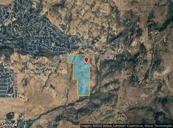
5500 Hillcrest Rd, Medford, OR 97504

NEARBY LISTINGS FOR SALE OR LEASE
Property Detail
5500 Hillcrest Rd
10425301
Quail Run Ranch Estates
Farms
Jackson
X
Oregon
41029C1985G
4
2024
97.08 AC
2025
Medford/Grants Pass
002500
Other Market Areas
9,783 SF
Medford, OR
DEMOGRAPHICS near 5500 Hillcrest Rd
1 Mile
3 Mile
5 Mile
2024 Total Population
1,949
15,376
63,442
2029 Population
1,968
15,563
63,468
Pop Growth 2024-2029
+ 0.97%
+ 1.22%
+ 0.04%
Average Age
46
46
43
2024 Total Households
726
6,219
26,245
HH Growth 2024-2029
+ 0.96%
+ 1.09%
(0.08%)
Median Household Inc
$106,250
$87,237
$64,257
Avg Household Size
2.60
2.40
2.30
2024 Avg HH Vehicles
3.00
2.00
2.00
Median Home Value
$558,000
$478,670
$373,789
Median Year Built
1997
1995
1984
Nearby Places
Map Layers
Map Styles
 Street
 Aerial
- Restaurants
- Banks
- Shops
- Fitness
- Groceries
PUBLIC TRANSPORTATION
AIRPORT
Rogue Valley International - Medford
DRIVE
WALK
Distance
Rogue Valley International - Medford
16 min
7.5 mi
Freight Ports
Port of Coos Bay, OR
DRIVE
WALK
Distance
Port of Coos Bay, OR
227 min
170.0 mi
SALE & LEASE HISTORY
LISTING DATE
SALE/LEASE

Jan 20, 2022
For Sale
Nearby Properties
Address
Land Use
TOTAL SIZE
Lot Size
Zoning
Address
Land Use
TOTAL SIZE
Lot Size
Zoning
762,720 SF
16.25 AC
C-S/P
Address
Land Use
TOTAL SIZE
Lot Size
Zoning
5.22 AC
MFR-30
Address
Land Use
TOTAL SIZE
Lot Size
Zoning
127.94 AC
SFR-4
Address
Land Use
TOTAL SIZE
Lot Size
Zoning
218,142 SF
8.36 AC
MFR-20
Address
Land Use
TOTAL SIZE
Lot Size
Zoning
92,000 SF
3.39 AC
MFR-30
Address
Land Use
TOTAL SIZE
Lot Size
Zoning
22,504 SF
1.88 AC
C-S/P
Address
Land Use
TOTAL SIZE
Lot Size
Zoning
38,400 SF
2.03 AC
C-S/P
Address
Land Use
TOTAL SIZE
Lot Size
Zoning
13,416 SF
1.64 AC
MFR-20
Address
Land Use
TOTAL SIZE
Lot Size
Zoning
18,611 SF
1.54 AC
C-C
Address
Land Use
TOTAL SIZE
Lot Size
Zoning
1 AC
RR-5
Address
Land Use
TOTAL SIZE
Lot Size
Zoning
35,592 SF
4.08 AC
C-C
Address
Land Use
TOTAL SIZE
Lot Size
Zoning
49,680 SF
2.87 AC
C-S/P
Address
Land Use
TOTAL SIZE
Lot Size
Zoning
57,364 SF
1.58 AC
SFR-10
Address
Land Use
TOTAL SIZE
Lot Size
Zoning
40,000 SF
2.76 AC
C-C
Address
Land Use
TOTAL SIZE
Lot Size
Zoning
60,776 SF
3.31 AC
MFR-30
Address
Land Use
TOTAL SIZE
Lot Size
Zoning
52.18 AC
OSR
Address
Land Use
TOTAL SIZE
Lot Size
Zoning
49,243 SF
2.56 AC
MFR-30
Address
Land Use
TOTAL SIZE
Lot Size
Zoning
105,537 SF
2.17 AC
SFR-10
Address
Land Use
TOTAL SIZE
Lot Size
Zoning
18,532 SF
1.28 AC
MFR-20
Address
Land Use
TOTAL SIZE
Lot Size
Zoning
31,586 SF
1.49 AC
C-S/P
Address
Land Use
TOTAL SIZE
Lot Size
Zoning
12,632 SF
0.29 AC
C-S/P
Address
Land Use
TOTAL SIZE
Lot Size
Zoning
10.40 AC
EFU
Address
Land Use
TOTAL SIZE
Lot Size
Zoning
32,292 SF
1.11 AC
MFR-30
Address
Land Use
TOTAL SIZE
Lot Size
Zoning
28,315 SF
2.31 AC
MFR-30
Address
Land Use
TOTAL SIZE
Lot Size
Zoning
60,796 SF
1.53 AC
MFR-30
Address
Land Use
TOTAL SIZE
Lot Size
Zoning
50,466 SF
2.66 AC
C-C
Address
Land Use
TOTAL SIZE
Lot Size
Zoning
18,934 SF
1.61 AC
C-S/P
Address
Land Use
TOTAL SIZE
Lot Size
Zoning
55,076 SF
5.07 AC
SFR-4
Address
Land Use
TOTAL SIZE
Lot Size
Zoning
20,301 SF
0.85 AC
C-S/P
Address
Land Use
TOTAL SIZE
Lot Size
Zoning
32,208 SF
2.24 AC
MFR-30
The World's #1 Commercial Real Estate Marketplace
Connect with us
© 2025 CoStar Group
The information above has been obtained from sources believed reliable. While we do not doubt its accuracy we have not verified it and make no guarantee, warranty or representation about it. It is your responsibility to independently confirm its accuracy and completeness. Any projections, opinions, assumptions, or estimates used are for example only and do not represent the current or future performance of the property. The value of this transaction to you depends on tax and other factors which should be evaluated by your tax, financial, and legal advisors. You and your advisors should conduct a careful, independent investigation of the property to determine to your satisfaction the suitability of the property for your needs.