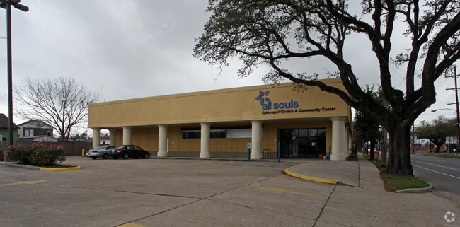
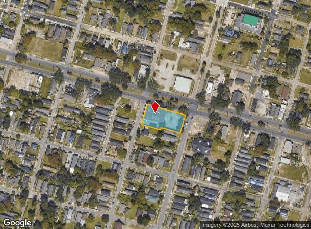
Property Record
5500 Saint Claude Ave, New Orleans, LA 70117

This Property Is For Sale
NEARBY LISTINGS FOR SALE OR LEASE
Property Detail
5500 Saint Claude Ave
New Orleans-Metairie, LA
Holy Cross
3-9W-2-046-01
SQ 335 ST CLAUDE AV AND FLOOD ST LOT 4X 163/130-35X123-15/138 LOTS 1, 2, 3 32X123 EACH
Nightclub
Orleans
AE
Louisiana
22051C0225F
4x,1-2
2025
0.51 AC
2025
Chalmette
000800
New Orleans/Metairie/Kenner
12,836 SF
DEMOGRAPHICS near 5500 Saint Claude Ave
1 Mile
3 Mile
5 Mile
2024 Total Population
10,299
83,052
277,114
2029 Population
10,187
81,388
269,531
Pop Growth 2024-2029
(1.09%)
(2.00%)
(2.74%)
Average Age
40
41
40
2024 Total Households
4,253
36,515
121,071
HH Growth 2024-2029
(1.32%)
(2.16%)
(2.76%)
Median Household Inc
$34,542
$39,993
$42,450
Avg Household Size
2.30
2.20
2.20
2024 Avg HH Vehicles
1.00
1.00
1.00
Median Home Value
$186,357
$213,216
$224,762
Median Year Built
1954
1956
1961
Nearby Places
Map Layers
Map Styles
 Street
 Aerial
- Restaurants
- Banks
- Shops
- Fitness
- Groceries
PUBLIC TRANSPORTATION
AIRPORT
Louis Armstrong New Orleans International
DRIVE
WALK
Distance
Louis Armstrong New Orleans International
33 min
18.2 mi
Nearby Properties
Address
Land Use
TOTAL SIZE
Lot Size
Zoning
Address
Land Use
TOTAL SIZE
Lot Size
Zoning
Address
Land Use
TOTAL SIZE
Lot Size
Zoning
18.31 AC
CBD-4
Address
Land Use
TOTAL SIZE
Lot Size
Zoning
6.64 AC
Address
Land Use
TOTAL SIZE
Lot Size
Zoning
844,362 SF
5.85 AC
CBD-4
Address
Land Use
TOTAL SIZE
Lot Size
Zoning
30.63 AC
Address
Land Use
TOTAL SIZE
Lot Size
Zoning
22.17 AC
Address
Land Use
TOTAL SIZE
Lot Size
Zoning
576,962 SF
3.31 AC
CBD-4
Address
Land Use
TOTAL SIZE
Lot Size
Zoning
1.33 AC
HI
Address
Land Use
TOTAL SIZE
Lot Size
Zoning
1.79 AC
Address
Land Use
TOTAL SIZE
Lot Size
Zoning
202,291 SF
4.04 AC
HU-RD2
Address
Land Use
TOTAL SIZE
Lot Size
Zoning
189,613 SF
71.45 AC
S-RD
Address
Land Use
TOTAL SIZE
Lot Size
Zoning
288,736 SF
0.84 AC
VCC-2
Address
Land Use
TOTAL SIZE
Lot Size
Zoning
85,568 SF
23.74 AC
MU-1
Address
Land Use
TOTAL SIZE
Lot Size
Zoning
Address
Land Use
TOTAL SIZE
Lot Size
Zoning
148,746 SF
2.19 AC
HMR-3
Address
Land Use
TOTAL SIZE
Lot Size
Zoning
109,688 SF
8.77 AC
S-RM1
Address
Land Use
TOTAL SIZE
Lot Size
Zoning
435,927 SF
2.92 AC
CBD-4
Address
Land Use
TOTAL SIZE
Lot Size
Zoning
1.91 AC
HU-MU
Address
Land Use
TOTAL SIZE
Lot Size
Zoning
31,384 SF
0.74 AC
VCC-2
Address
Land Use
TOTAL SIZE
Lot Size
Zoning
Address
Land Use
TOTAL SIZE
Lot Size
Zoning
332,393 SF
6.39 AC
CBD-4
Address
Land Use
TOTAL SIZE
Lot Size
Zoning
143,315 SF
0.80 AC
VCE
Address
Land Use
TOTAL SIZE
Lot Size
Zoning
Address
Land Use
TOTAL SIZE
Lot Size
Zoning
7.02 AC
CBD-4
Address
Land Use
TOTAL SIZE
Lot Size
Zoning
3.43 AC
HMR-3
Address
Land Use
TOTAL SIZE
Lot Size
Zoning
1.88 AC
HU-RD2
Address
Land Use
TOTAL SIZE
Lot Size
Zoning
10.14 AC
Address
Land Use
TOTAL SIZE
Lot Size
Zoning
183,132 SF
2.31 AC
VCC-2
Address
Land Use
TOTAL SIZE
Lot Size
Zoning
Address
Land Use
TOTAL SIZE
Lot Size
Zoning
The World's #1 Commercial Real Estate Marketplace
Connect with us
© 2026 CoStar Group
The information above has been obtained from sources believed reliable. While we do not doubt its accuracy we have not verified it and make no guarantee, warranty or representation about it. It is your responsibility to independently confirm its accuracy and completeness. Any projections, opinions, assumptions, or estimates used are for example only and do not represent the current or future performance of the property. The value of this transaction to you depends on tax and other factors which should be evaluated by your tax, financial, and legal advisors. You and your advisors should conduct a careful, independent investigation of the property to determine to your satisfaction the suitability of the property for your needs.