Property Record
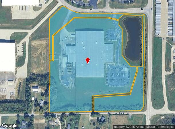
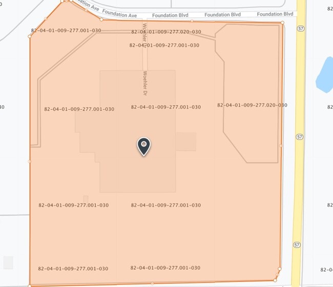
5501 Foundation Blvd, Evansville, IN 47725

NEARBY LISTINGS FOR SALE OR LEASE
Property Detail
5501 Foundation Blvd
Evansville, IN
Vanderburgh Industrial Park
82-04-01-009-277.001-030
VANDERBURGH INDUSTRIAL PARK PT LOTS 1, 2, 3, 4
Manufacturinglight
Vanderburgh
X
Indiana
18173C0105D
1-4
2024
21.36 AC
2024
Northside/Airport
010701
Evansville
159,200 SF
DEMOGRAPHICS near 5501 Foundation Blvd
1 Mile
3 Mile
5 Mile
2024 Total Population
423
6,461
20,857
2029 Population
425
6,473
20,856
Pop Growth 2024-2029
+ 0.47%
+ 0.19%
0.00%
Average Age
37
39
40
2024 Total Households
154
2,393
7,728
HH Growth 2024-2029
+ 0.65%
+ 0.13%
(0.03%)
Median Household Inc
$86,890
$91,023
$97,230
Avg Household Size
2.70
2.70
2.70
2024 Avg HH Vehicles
2.00
2.00
2.00
Median Home Value
$181,764
$213,404
$246,631
Median Year Built
2004
2002
1999
Nearby Places
Map Layers
Map Styles
 Street
 Aerial
- Restaurants
- Banks
- Shops
- Fitness
- Groceries
PUBLIC TRANSPORTATION
AIRPORT
Evansville Regional
DRIVE
WALK
Distance
Evansville Regional
15 min
6.6 mi
Freight Ports
Port of Toledo
DRIVE
WALK
Distance
Port of Toledo
442 min
380.7 mi
Nearby Properties
Address
Land Use
TOTAL SIZE
Lot Size
Zoning
Address
Land Use
TOTAL SIZE
Lot Size
Zoning
409,682 SF
42.31 AC
Address
Land Use
TOTAL SIZE
Lot Size
Zoning
266,660 SF
23.57 AC
Address
Land Use
TOTAL SIZE
Lot Size
Zoning
22.09 AC
Address
Land Use
TOTAL SIZE
Lot Size
Zoning
100,000 SF
12.15 AC
Address
Land Use
TOTAL SIZE
Lot Size
Zoning
75,000 SF
11.72 AC
Address
Land Use
TOTAL SIZE
Lot Size
Zoning
100,000 SF
12.67 AC
Address
Land Use
TOTAL SIZE
Lot Size
Zoning
75,004 SF
11.66 AC
Address
Land Use
TOTAL SIZE
Lot Size
Zoning
70,000 SF
21.33 AC
Address
Land Use
TOTAL SIZE
Lot Size
Zoning
40,289 SF
19.02 AC
Address
Land Use
TOTAL SIZE
Lot Size
Zoning
61,970 SF
10.36 AC
Address
Land Use
TOTAL SIZE
Lot Size
Zoning
58,800 SF
4.70 AC
Address
Land Use
TOTAL SIZE
Lot Size
Zoning
22,964 SF
15.73 AC
Address
Land Use
TOTAL SIZE
Lot Size
Zoning
31,655 SF
15.26 AC
Address
Land Use
TOTAL SIZE
Lot Size
Zoning
53,024 SF
2.86 AC
Address
Land Use
TOTAL SIZE
Lot Size
Zoning
15,180 SF
3.05 AC
Address
Land Use
TOTAL SIZE
Lot Size
Zoning
20,441 SF
5.17 AC
4
Address
Land Use
TOTAL SIZE
Lot Size
Zoning
9,648 SF
2.17 AC
Address
Land Use
TOTAL SIZE
Lot Size
Zoning
41,250 SF
3.23 AC
Address
Land Use
TOTAL SIZE
Lot Size
Zoning
14,758 SF
5.01 AC
Address
Land Use
TOTAL SIZE
Lot Size
Zoning
65,625 SF
15.20 AC
Address
Land Use
TOTAL SIZE
Lot Size
Zoning
29,550 SF
13.38 AC
Address
Land Use
TOTAL SIZE
Lot Size
Zoning
8,946 SF
4.13 AC
Address
Land Use
TOTAL SIZE
Lot Size
Zoning
5,200 SF
2.99 AC
Address
Land Use
TOTAL SIZE
Lot Size
Zoning
47,277 SF
4.65 AC
Address
Land Use
TOTAL SIZE
Lot Size
Zoning
16,940 SF
9.80 AC
4
Address
Land Use
TOTAL SIZE
Lot Size
Zoning
45,912 SF
10 AC
4
Address
Land Use
TOTAL SIZE
Lot Size
Zoning
4,005 SF
3.12 AC
Address
Land Use
TOTAL SIZE
Lot Size
Zoning
10,640 SF
1.96 AC
Address
Land Use
TOTAL SIZE
Lot Size
Zoning
21,450 SF
4.75 AC
The World's #1 Commercial Real Estate Marketplace
Connect with us
© 2026 CoStar Group
The information above has been obtained from sources believed reliable. While we do not doubt its accuracy we have not verified it and make no guarantee, warranty or representation about it. It is your responsibility to independently confirm its accuracy and completeness. Any projections, opinions, assumptions, or estimates used are for example only and do not represent the current or future performance of the property. The value of this transaction to you depends on tax and other factors which should be evaluated by your tax, financial, and legal advisors. You and your advisors should conduct a careful, independent investigation of the property to determine to your satisfaction the suitability of the property for your needs.