Property Record
5501 Millerton Rd, Friant, CA 93626
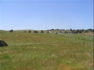
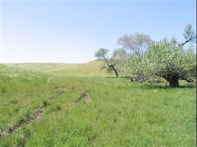

Property Detail
5501 Millerton Rd
300-021-81
20 AC IN NE1/4 OF NE1/4 SEC 17 T11R21
Pasture
FRESNO
AE40
California
B and X Area of moderate flood hazard, usually the area between the limits of the 100-year and 500-year floods.
102.65 AC
2025
E Outlying Fresno County
2025
Fresno
006405
Fresno, CA
NEARBY LISTINGS FOR SALE OR LEASE
DEMOGRAPHICS near 5501 Millerton Rd
1 mile
3 mile
5 mile
2025 Total Population
656
2,007
2,916
2030 Population
687
2,079
3,016
Pop Growth 2025-2030
+ 4.73%
+ 3.59%
+ 3.43%
Average Age
42
43
43
2025 Total Households
229
709
1,046
HH Growth 2025-2030
+ 4.80%
+ 3.53%
+ 3.35%
Median Household Inc
$128,409
$136,785
$127,727
Avg Household Size
2.80
2.80
2.70
2025 Avg HH Vehicles
3.00
3.00
3.00
Median Home Value
$689,597
$711,492
$697,664
Median Year Built
1996
1995
1994
Nearby Places
Map Layers
Map Styles
 Street
 Aerial
Transit
 Traffic
 Biking
Places
Listings with unknown addresses are not visible on the map
- Restaurants
- Banks
- Shops
- Fitness
- Groceries
PUBLIC TRANSPORTATION
AIRPORT
Fresno Yosemite International
Drive
Walk
Distance
Fresno Yosemite International
34 min
18.6 mi
Freight Ports
Port of Stockton
Drive
Walk
Distance
Port of Stockton
168 min
128.4 mi
Nearby Properties
Address
Land Use
TOTAL SIZE
Lot Size
Zoning
Address
Land Use
TOTAL SIZE
Lot Size
Zoning
1,403 SF
234.59 AC
ARF
Address
Land Use
TOTAL SIZE
Lot Size
Zoning
9,036 SF
178.76 AC
RIBCUP
Address
Land Use
TOTAL SIZE
Lot Size
Zoning
9,900 SF
8.97 AC
RA
Address
Land Use
TOTAL SIZE
Lot Size
Zoning
11,376 SF
1.06 AC
C6
Address
Land Use
TOTAL SIZE
Lot Size
Zoning
4,556 SF
39.43 AC
AL40
Address
Land Use
TOTAL SIZE
Lot Size
Zoning
5,942 SF
1.38 AC
R1B
Address
Land Use
TOTAL SIZE
Lot Size
Zoning
3,688 SF
39.39 AC
AL40
Address
Land Use
TOTAL SIZE
Lot Size
Zoning
125.68 AC
AL40
Address
Land Use
TOTAL SIZE
Lot Size
Zoning
3,668 SF
0.25 AC
Address
Land Use
TOTAL SIZE
Lot Size
Zoning
4.47 AC
RR
Address
Land Use
TOTAL SIZE
Lot Size
Zoning
12.96 AC
R1B
Address
Land Use
TOTAL SIZE
Lot Size
Zoning
16.39 AC
RR
Address
Land Use
TOTAL SIZE
Lot Size
Zoning
2,813 SF
0.16 AC
Address
Land Use
TOTAL SIZE
Lot Size
Zoning
2,514 SF
0.14 AC
Address
Land Use
TOTAL SIZE
Lot Size
Zoning
2,032 SF
0.23 AC
Address
Land Use
TOTAL SIZE
Lot Size
Zoning
1,907 SF
0.15 AC
Address
Land Use
TOTAL SIZE
Lot Size
Zoning
3,484 SF
0.53 AC
R1B
Address
Land Use
TOTAL SIZE
Lot Size
Zoning
39.01 AC
RR
Address
Land Use
TOTAL SIZE
Lot Size
Zoning
3,537 SF
0.28 AC
R1
Address
Land Use
TOTAL SIZE
Lot Size
Zoning
2,971 SF
0.31 AC
R1
Address
Land Use
TOTAL SIZE
Lot Size
Zoning
2,688 SF
0.80 AC
C6
Address
Land Use
TOTAL SIZE
Lot Size
Zoning
3,537 SF
0.20 AC
R1
Address
Land Use
TOTAL SIZE
Lot Size
Zoning
3,956 SF
0.88 AC
C6
Address
Land Use
TOTAL SIZE
Lot Size
Zoning
2,303 SF
0.19 AC
R1
Address
Land Use
TOTAL SIZE
Lot Size
Zoning
2,303 SF
0.27 AC
R1
The World's #1 Commercial Real Estate Marketplace
Connect with us
© 2026 CoStar Group
The information above has been obtained from sources believed reliable. While we do not doubt its accuracy we have not verified it and make no guarantee, warranty or representation about it. It is your responsibility to independently confirm its accuracy and completeness. Any projections, opinions, assumptions, or estimates used are for example only and do not represent the current or future performance of the property. The value of this transaction to you depends on tax and other factors which should be evaluated by your tax, financial, and legal advisors. You and your advisors should conduct a careful, independent investigation of the property to determine to your satisfaction the suitability of the property for your needs.