Property Record
5501 S Expressway 77/83, Harlingen, TX 78550


NEARBY LISTINGS FOR SALE OR LEASE
-
-
View all Harlingen listings for sale on LoopNet.com
Property Detail
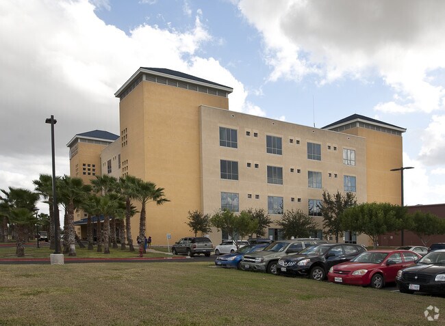
5501 S Expressway 77/83
Brownsville-Harlingen, TX
Harlingen Medical Center Subd
230694-0010-001000
HARLINGEN MEDICAL CENTER LOT 1 BLK 1 (CAB 1 SLOT 2016-A CCMR)
Commercialnec
Cameron
AE
Texas
48061C0270F
1
2024
13.31 AC
2025
Greater Harlingen
010700
Brownsville/Harlingen
186,716 SF
DEMOGRAPHICS near 5501 S Expressway 77/83
1 Mile
3 Mile
5 Mile
2024 Total Population
4,707
48,227
96,600
2029 Population
4,750
49,560
98,986
Pop Growth 2024-2029
+ 0.91%
+ 2.76%
+ 2.47%
Average Age
40
37
37
2024 Total Households
1,727
16,415
32,630
HH Growth 2024-2029
+ 0.81%
+ 2.69%
+ 2.40%
Median Household Inc
$29,124
$41,514
$45,487
Avg Household Size
2.50
2.80
2.80
2024 Avg HH Vehicles
1.00
2.00
2.00
Median Home Value
$112,191
$82,890
$90,344
Median Year Built
1987
1983
1984
Nearby Places
Map Layers
Map Styles
 Street
 Aerial
- Restaurants
- Banks
- Shops
- Fitness
- Groceries
PUBLIC TRANSPORTATION
AIRPORT
Valley International
DRIVE
WALK
Distance
Valley International
19 min
7.0 mi
Brownsville/South Padre Island International
DRIVE
WALK
Distance
Brownsville/South Padre Island International
35 min
25.7 mi
McAllen International
DRIVE
WALK
Distance
McAllen International
47 min
38.5 mi
Freight Ports
Port of Brownsville
DRIVE
WALK
Distance
Port of Brownsville
28 min
23.3 mi
Nearby Properties
Address
Land Use
TOTAL SIZE
Lot Size
Zoning
Address
Land Use
TOTAL SIZE
Lot Size
Zoning
758,640 SF
11.31 AC
Address
Land Use
TOTAL SIZE
Lot Size
Zoning
427,448 SF
6.94 AC
Address
Land Use
TOTAL SIZE
Lot Size
Zoning
89,797 SF
7.90 AC
Address
Land Use
TOTAL SIZE
Lot Size
Zoning
159,787 SF
10.66 AC
Address
Land Use
TOTAL SIZE
Lot Size
Zoning
176,365 SF
14.65 AC
Address
Land Use
TOTAL SIZE
Lot Size
Zoning
135,258 SF
4.26 AC
C
Address
Land Use
TOTAL SIZE
Lot Size
Zoning
148,596 SF
1 AC
Address
Land Use
TOTAL SIZE
Lot Size
Zoning
118,561 SF
6.32 AC
C
Address
Land Use
TOTAL SIZE
Lot Size
Zoning
77,189 SF
3.28 AC
Address
Land Use
TOTAL SIZE
Lot Size
Zoning
62,764 SF
10 AC
Address
Land Use
TOTAL SIZE
Lot Size
Zoning
61,920 SF
5.60 AC
C
Address
Land Use
TOTAL SIZE
Lot Size
Zoning
155,425 SF
20.77 AC
C
Address
Land Use
TOTAL SIZE
Lot Size
Zoning
1,152 SF
44.60 AC
C
Address
Land Use
TOTAL SIZE
Lot Size
Zoning
138,862 SF
15.82 AC
Address
Land Use
TOTAL SIZE
Lot Size
Zoning
206,973 SF
12.77 AC
Address
Land Use
TOTAL SIZE
Lot Size
Zoning
230,267 SF
7.85 AC
C
Address
Land Use
TOTAL SIZE
Lot Size
Zoning
76,722 SF
8.26 AC
Address
Land Use
TOTAL SIZE
Lot Size
Zoning
180,838 SF
12.56 AC
C
Address
Land Use
TOTAL SIZE
Lot Size
Zoning
78,223 SF
20.85 AC
Address
Land Use
TOTAL SIZE
Lot Size
Zoning
47,558 SF
7 AC
Address
Land Use
TOTAL SIZE
Lot Size
Zoning
90,376 SF
1.93 AC
Address
Land Use
TOTAL SIZE
Lot Size
Zoning
176,627 SF
12.45 AC
A-C
Address
Land Use
TOTAL SIZE
Lot Size
Zoning
42,557 SF
1.74 AC
C
Address
Land Use
TOTAL SIZE
Lot Size
Zoning
145,232 SF
6.38 AC
Address
Land Use
TOTAL SIZE
Lot Size
Zoning
84,936 SF
12 AC
Address
Land Use
TOTAL SIZE
Lot Size
Zoning
108,000 SF
10.44 AC
C
Address
Land Use
TOTAL SIZE
Lot Size
Zoning
93,459 SF
20 AC
Address
Land Use
TOTAL SIZE
Lot Size
Zoning
147,186 SF
10 AC
Address
Land Use
TOTAL SIZE
Lot Size
Zoning
54,605 SF
25.70 AC
A-C
The World's #1 Commercial Real Estate Marketplace
Connect with us
© 2026 CoStar Group
The information above has been obtained from sources believed reliable. While we do not doubt its accuracy we have not verified it and make no guarantee, warranty or representation about it. It is your responsibility to independently confirm its accuracy and completeness. Any projections, opinions, assumptions, or estimates used are for example only and do not represent the current or future performance of the property. The value of this transaction to you depends on tax and other factors which should be evaluated by your tax, financial, and legal advisors. You and your advisors should conduct a careful, independent investigation of the property to determine to your satisfaction the suitability of the property for your needs.