Property Record
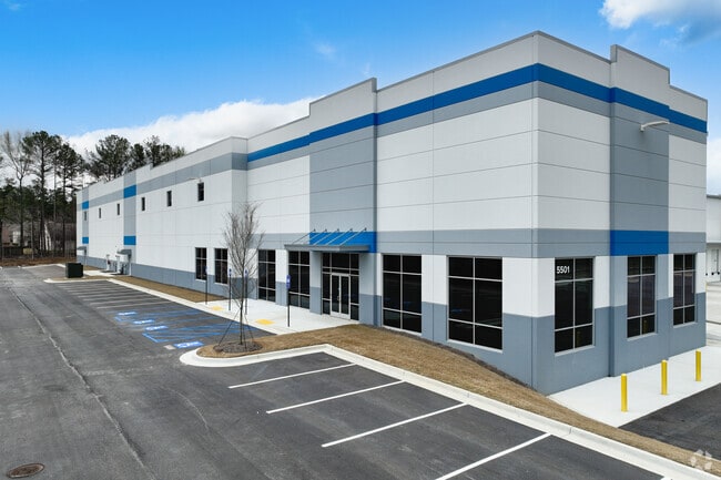
5501 Westmoreland Plz, Douglasville, GA 30134
Current Lease Availabilities
NEARBY LISTINGS FOR SALE OR LEASE
-
-
-
-
No Photo
-
-
-
View all Douglasville listings for lease on LoopNet.com
Property Detail
5501 Westmoreland Plz
3182-09-0-0-005
Point Of View S/D
Warehouse
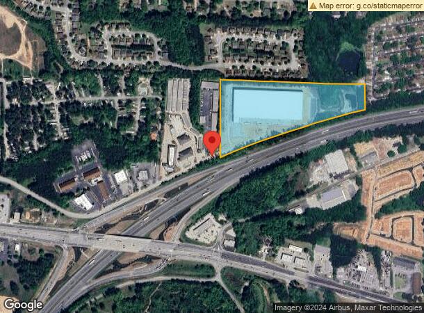
V/14.30 AC.+, OFF WESTMORELAND PLAZA
AE
Douglas
13097C0064D
Georgia
2024
14.30 AC
2024
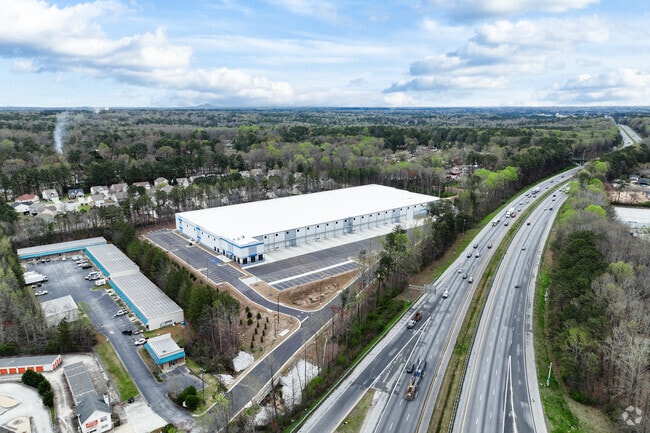
I-20 W/Douglasville
080303
Atlanta
170,778 SF
Atlanta-Sandy Springs-Roswell, GA
DEMOGRAPHICS near 5501 Westmoreland Plz
1 Mile
3 Mile
5 Mile
2024 Total Population
5,190
42,184
100,128
2029 Population
5,481
44,674
105,864
Pop Growth 2024-2029
+ 5.61%
+ 5.90%
+ 5.73%
Average Age
37
37
37
2024 Total Households
1,881
14,941
35,628
HH Growth 2024-2029
+ 5.64%
+ 5.98%
+ 5.75%
Median Household Inc
$49,104
$60,616
$64,340
Avg Household Size
2.70
2.70
2.80
2024 Avg HH Vehicles
2.00
2.00
2.00
Median Home Value
$177,087
$196,771
$199,591
Median Year Built
1981
1989
1993
Nearby Places
Map Layers
Map Styles
 Street
 Aerial
- Restaurants
- Banks
- Shops
- Fitness
- Groceries
PUBLIC TRANSPORTATION
AIRPORT
Hartsfield - Jackson Atlanta International
DRIVE
WALK
Distance
Hartsfield - Jackson Atlanta International
40 min
28.9 mi
Freight Ports
Georgia Ports - Savannah
DRIVE
WALK
Distance
Georgia Ports - Savannah
303 min
268.2 mi
Nearby Properties
Address
Land Use
TOTAL SIZE
Lot Size
Zoning
Address
Land Use
TOTAL SIZE
Lot Size
Zoning
331,774 SF
37.68 AC
DCD
Address
Land Use
TOTAL SIZE
Lot Size
Zoning
263,326 SF
24.07 AC
CG
Address
Land Use
TOTAL SIZE
Lot Size
Zoning
449,595 SF
10.93 AC
R-2
Address
Land Use
TOTAL SIZE
Lot Size
Zoning
165,730 SF
17.35 AC
R-6
Address
Land Use
TOTAL SIZE
Lot Size
Zoning
181,768 SF
25 AC
R-MF
Address
Land Use
TOTAL SIZE
Lot Size
Zoning
167,376 SF
16.53 AC
R-6
Address
Land Use
TOTAL SIZE
Lot Size
Zoning
102,252 SF
8.68 AC
R-2
Address
Land Use
TOTAL SIZE
Lot Size
Zoning
224,137 SF
22.83 AC
CG
Address
Land Use
TOTAL SIZE
Lot Size
Zoning
100,462 SF
10.21 AC
CG
Address
Land Use
TOTAL SIZE
Lot Size
Zoning
26,274 SF
2.42 AC
OI-L
Address
Land Use
TOTAL SIZE
Lot Size
Zoning
45,088 SF
3.23 AC
OI-L
Address
Land Use
TOTAL SIZE
Lot Size
Zoning
110,489 SF
10.71 AC
R-6
Address
Land Use
TOTAL SIZE
Lot Size
Zoning
134,175 SF
15.99 AC
001
Address
Land Use
TOTAL SIZE
Lot Size
Zoning
58,854 SF
3.07 AC
OI-L
Address
Land Use
TOTAL SIZE
Lot Size
Zoning
87,472 SF
9.10 AC
DCD
Address
Land Use
TOTAL SIZE
Lot Size
Zoning
55,232 SF
4.28 AC
DCD
Address
Land Use
TOTAL SIZE
Lot Size
Zoning
49,148 SF
3.38 AC
CG
Address
Land Use
TOTAL SIZE
Lot Size
Zoning
41,925 SF
3.77 AC
DCD
Address
Land Use
TOTAL SIZE
Lot Size
Zoning
86,140 SF
10.88 AC
CG
Address
Land Use
TOTAL SIZE
Lot Size
Zoning
103,676 SF
7.36 AC
CG
Address
Land Use
TOTAL SIZE
Lot Size
Zoning
42,200 SF
2.96 AC
DCD
Address
Land Use
TOTAL SIZE
Lot Size
Zoning
67,480 SF
9.98 AC
C-G
Address
Land Use
TOTAL SIZE
Lot Size
Zoning
129,646 SF
9.80 AC
CG
Address
Land Use
TOTAL SIZE
Lot Size
Zoning
41,584 SF
3.90 AC
DCD
Address
Land Use
TOTAL SIZE
Lot Size
Zoning
95,854 SF
17.75 AC
LI
Address
Land Use
TOTAL SIZE
Lot Size
Zoning
115,200 SF
8.74 AC
LI
Address
Land Use
TOTAL SIZE
Lot Size
Zoning
78,018 SF
8.53 AC
CG
Address
Land Use
TOTAL SIZE
Lot Size
Zoning
38,594 SF
5.18 AC
O-I
Address
Land Use
TOTAL SIZE
Lot Size
Zoning
109,917 SF
2.26 AC
CG
The World's #1 Commercial Real Estate Marketplace
Connect with us
© 2026 CoStar Group
The information above has been obtained from sources believed reliable. While we do not doubt its accuracy we have not verified it and make no guarantee, warranty or representation about it. It is your responsibility to independently confirm its accuracy and completeness. Any projections, opinions, assumptions, or estimates used are for example only and do not represent the current or future performance of the property. The value of this transaction to you depends on tax and other factors which should be evaluated by your tax, financial, and legal advisors. You and your advisors should conduct a careful, independent investigation of the property to determine to your satisfaction the suitability of the property for your needs.