Property Record
5502 S Dupont Hwy, Dover, DE 19901
NEARBY LISTINGS FOR SALE OR LEASE
Property Detail
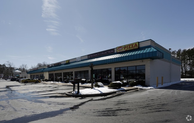
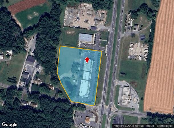
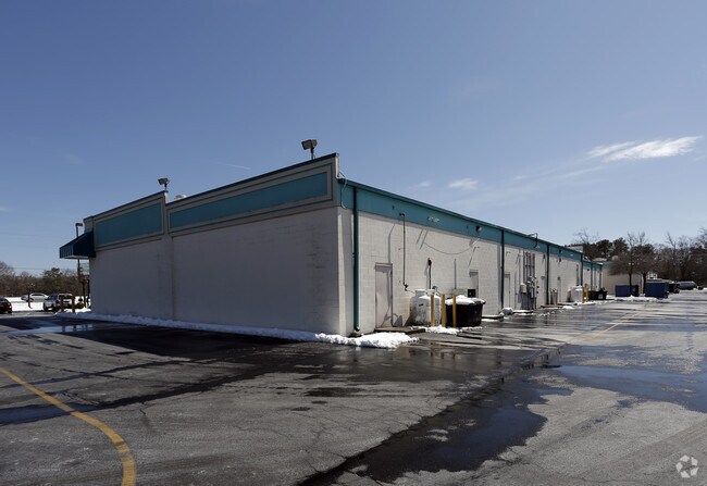
5502 S Dupont Hwy
7-00-11100-01-2001-000
N.W. INTERSEC. OF RT. #13 & WALNUT SHADE RD. 5.29 A.
Commercialnec
Kent
X
Delaware
10001C0233J
5.29 AC
2025
Kent County
2025
Philadelphia
042100
Dover, DE
12,100 SF
DEMOGRAPHICS near 5502 S Dupont Hwy
1 Mile
3 Mile
5 Mile
2024 Total Population
1,892
23,355
54,307
2029 Population
2,036
25,061
58,082
Pop Growth 2024-2029
+ 7.61%
+ 7.30%
+ 6.95%
Average Age
43
41
40
2024 Total Households
716
8,546
20,055
HH Growth 2024-2029
+ 7.82%
+ 7.51%
+ 7.21%
Median Household Inc
$58,181
$73,649
$73,873
Avg Household Size
2.50
2.70
2.70
2024 Avg HH Vehicles
1.00
2.00
2.00
Median Home Value
$237,556
$294,757
$290,832
Median Year Built
1991
1999
1994
Nearby Places
Map Layers
Map Styles
 Street
 Aerial
- Restaurants
- Banks
- Shops
- Fitness
- Groceries
SALE & LEASE HISTORY
LISTING DATE
SALE/LEASE

Sep 25, 2016
For Lease
Jun 12, 2018
For Lease
Nearby Properties
Address
Land Use
TOTAL SIZE
Lot Size
Zoning
Address
Land Use
TOTAL SIZE
Lot Size
Zoning
309,792 SF
108.80 AC
AC
Address
Land Use
TOTAL SIZE
Lot Size
Zoning
5,529 SF
83.30 AC
NA
Address
Land Use
TOTAL SIZE
Lot Size
Zoning
190,988 SF
19.90 AC
NA
Address
Land Use
TOTAL SIZE
Lot Size
Zoning
62,728 SF
25 AC
AC
Address
Land Use
TOTAL SIZE
Lot Size
Zoning
Address
Land Use
TOTAL SIZE
Lot Size
Zoning
125,394 SF
19.10 AC
RS1
Address
Land Use
TOTAL SIZE
Lot Size
Zoning
58,026 SF
17 AC
NA
Address
Land Use
TOTAL SIZE
Lot Size
Zoning
60,878 SF
6.80 AC
BG
Address
Land Use
TOTAL SIZE
Lot Size
Zoning
1,078 SF
34.20 AC
RMH
Address
Land Use
TOTAL SIZE
Lot Size
Zoning
23,924 SF
17.70 AC
RS1
Address
Land Use
TOTAL SIZE
Lot Size
Zoning
39,141 SF
4 AC
BG
Address
Land Use
TOTAL SIZE
Lot Size
Zoning
410.60 AC
AP/10
Address
Land Use
TOTAL SIZE
Lot Size
Zoning
42,765 SF
9.10 AC
NA
Address
Land Use
TOTAL SIZE
Lot Size
Zoning
9,384 SF
40.17 AC
AC
Address
Land Use
TOTAL SIZE
Lot Size
Zoning
101,620 SF
16.32 AC
NA
Address
Land Use
TOTAL SIZE
Lot Size
Zoning
19,352 SF
14.77 AC
RM
Address
Land Use
TOTAL SIZE
Lot Size
Zoning
24.80 AC
RMH
Address
Land Use
TOTAL SIZE
Lot Size
Zoning
49,061 SF
7.26 AC
RMH
Address
Land Use
TOTAL SIZE
Lot Size
Zoning
82.20 AC
AC
Address
Land Use
TOTAL SIZE
Lot Size
Zoning
1,720 SF
71.20 AC
AR
Address
Land Use
TOTAL SIZE
Lot Size
Zoning
31,465 SF
3.36 AC
NA
Address
Land Use
TOTAL SIZE
Lot Size
Zoning
11,421 SF
1.70 AC
NA
Address
Land Use
TOTAL SIZE
Lot Size
Zoning
7,175 SF
1.60 AC
NA
Address
Land Use
TOTAL SIZE
Lot Size
Zoning
23,805 SF
5 AC
BG
Address
Land Use
TOTAL SIZE
Lot Size
Zoning
17,820 SF
6.60 AC
NA
Address
Land Use
TOTAL SIZE
Lot Size
Zoning
14,504 SF
6.40 AC
NA
Address
Land Use
TOTAL SIZE
Lot Size
Zoning
418.90 AC
AC
Address
Land Use
TOTAL SIZE
Lot Size
Zoning
5,796 SF
1.53 AC
NA
Address
Land Use
TOTAL SIZE
Lot Size
Zoning
17,514 SF
1.30 AC
NA
The World's #1 Commercial Real Estate Marketplace
Connect with us
© 2026 CoStar Group
The information above has been obtained from sources believed reliable. While we do not doubt its accuracy we have not verified it and make no guarantee, warranty or representation about it. It is your responsibility to independently confirm its accuracy and completeness. Any projections, opinions, assumptions, or estimates used are for example only and do not represent the current or future performance of the property. The value of this transaction to you depends on tax and other factors which should be evaluated by your tax, financial, and legal advisors. You and your advisors should conduct a careful, independent investigation of the property to determine to your satisfaction the suitability of the property for your needs.