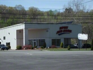
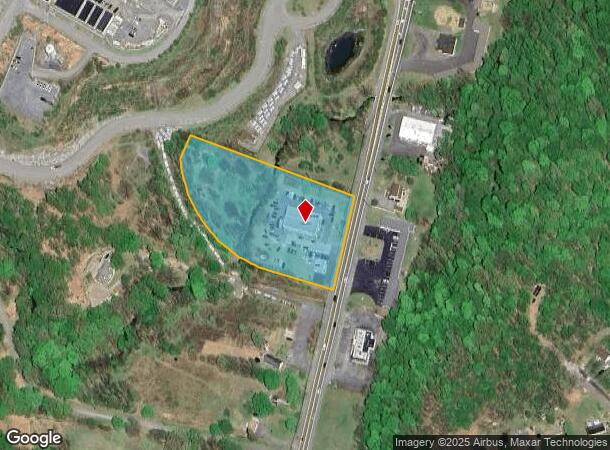
Property Record
5505 Route 9W, Newburgh, NY 12550

NEARBY LISTINGS FOR SALE OR LEASE
Property Detail
5505 Route 9W
334600-008-000-0001-015.100-0000
LT 1 SMITH & GERVAIS SUB MAP 8601
Autorepair
Orange
X
New York
36027C0453E
15.10
2024
3.10 AC
2024
Newburgh
010300
Northern New Jersey
5,700 SF
New York-Jersey City-White Plains, NY-NJ
DEMOGRAPHICS near 5505 Route 9W
1 Mile
3 Mile
5 Mile
2024 Total Population
2,110
15,374
64,756
2029 Population
2,133
15,344
65,203
Pop Growth 2024-2029
+ 1.09%
(0.20%)
+ 0.69%
Average Age
40
41
41
2024 Total Households
865
6,129
25,075
HH Growth 2024-2029
+ 1.16%
(0.28%)
+ 0.59%
Median Household Inc
$101,732
$104,559
$87,356
Avg Household Size
2.40
2.50
2.40
2024 Avg HH Vehicles
2.00
2.00
2.00
Median Home Value
$323,417
$361,909
$339,651
Median Year Built
1997
1977
1970
Nearby Places
- Restaurants
- Banks
- Shops
- Fitness
- Groceries
PUBLIC TRANSPORTATION
COMMUTER RAIL
Beacon Station (Hudson Line - Metro-North Commuter Railroad Company (Metro-North))
DRIVE
WALK
Distance
Beacon Station (Hudson Line - Metro-North Commuter Railroad Company (Metro-North))
12 min
8.1 mi
AIRPORT
New York Stewart International
DRIVE
WALK
Distance
New York Stewart International
19 min
11.7 mi
Freight Ports
Port of New Haven
DRIVE
WALK
Distance
Port of New Haven
105 min
78.5 mi
SALE & LEASE HISTORY
LISTING DATE
SALE/LEASE

May 13, 2019
For Sale
Nearby Properties
Address
Land Use
TOTAL SIZE
Lot Size
Zoning
Address
Land Use
TOTAL SIZE
Lot Size
Zoning
Address
Land Use
TOTAL SIZE
Lot Size
Zoning
114 AC
Address
Land Use
TOTAL SIZE
Lot Size
Zoning
94,340 SF
31.64 AC
RMF5
Address
Land Use
TOTAL SIZE
Lot Size
Zoning
21,996 SF
17.36 AC
RMF5
Address
Land Use
TOTAL SIZE
Lot Size
Zoning
141,167 SF
46.50 AC
R1
Address
Land Use
TOTAL SIZE
Lot Size
Zoning
1,095 SF
21.70 AC
R1
Address
Land Use
TOTAL SIZE
Lot Size
Zoning
50.90 AC
Address
Land Use
TOTAL SIZE
Lot Size
Zoning
35 AC
R40
Address
Land Use
TOTAL SIZE
Lot Size
Zoning
43,877 SF
10.10 AC
R1
Address
Land Use
TOTAL SIZE
Lot Size
Zoning
Address
Land Use
TOTAL SIZE
Lot Size
Zoning
22 AC
R40
Address
Land Use
TOTAL SIZE
Lot Size
Zoning
11.20 AC
CC
Address
Land Use
TOTAL SIZE
Lot Size
Zoning
138.90 AC
Address
Land Use
TOTAL SIZE
Lot Size
Zoning
54,908 SF
7.60 AC
HD
Address
Land Use
TOTAL SIZE
Lot Size
Zoning
14.30 AC
RAG1
Address
Land Use
TOTAL SIZE
Lot Size
Zoning
Address
Land Use
TOTAL SIZE
Lot Size
Zoning
32.30 AC
RMF5
Address
Land Use
TOTAL SIZE
Lot Size
Zoning
11,367 SF
14.97 AC
R80
Address
Land Use
TOTAL SIZE
Lot Size
Zoning
50,657 SF
15.60 AC
R1
Address
Land Use
TOTAL SIZE
Lot Size
Zoning
0.01 AC
R80
Address
Land Use
TOTAL SIZE
Lot Size
Zoning
Address
Land Use
TOTAL SIZE
Lot Size
Zoning
43,633 SF
99.63 AC
R80
Address
Land Use
TOTAL SIZE
Lot Size
Zoning
28,422 SF
38.70 AC
R40/80
Address
Land Use
TOTAL SIZE
Lot Size
Zoning
Address
Land Use
TOTAL SIZE
Lot Size
Zoning
40.30 AC
Address
Land Use
TOTAL SIZE
Lot Size
Zoning
3.50 AC
HB
Address
Land Use
TOTAL SIZE
Lot Size
Zoning
30,571 SF
3.12 AC
R40
Address
Land Use
TOTAL SIZE
Lot Size
Zoning
1,428 SF
19.85 AC
RAG1
Address
Land Use
TOTAL SIZE
Lot Size
Zoning
9,183 SF
31.43 AC
R40
Address
Land Use
TOTAL SIZE
Lot Size
Zoning
11,538 SF
2.79 AC
R20
The World's #1 Commercial Real Estate Marketplace
Connect with us
© 2025 CoStar Group
The information above has been obtained from sources believed reliable. While we do not doubt its accuracy we have not verified it and make no guarantee, warranty or representation about it. It is your responsibility to independently confirm its accuracy and completeness. Any projections, opinions, assumptions, or estimates used are for example only and do not represent the current or future performance of the property. The value of this transaction to you depends on tax and other factors which should be evaluated by your tax, financial, and legal advisors. You and your advisors should conduct a careful, independent investigation of the property to determine to your satisfaction the suitability of the property for your needs.