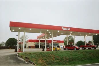
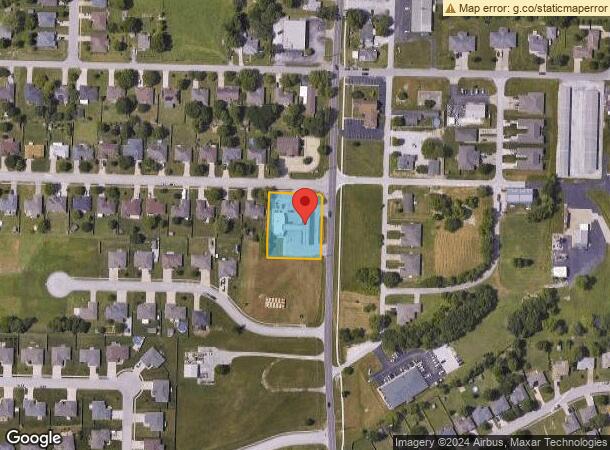
Property Record
5505 S State Highway Ff, Battlefield, MO 65619
NEARBY LISTINGS FOR SALE OR LEASE
Property Detail
5505 S State Highway Ff
Springfield, MO
Dogwood
18-19-400-114
DOGWOOD PLACE PHASE 2 REPLAT LOT 41 LOT 41
Storebuilding
Greene
X
Missouri
29043C0051D
41
2025
0.77 AC
2025
Outlying Greene County
004104
Springfield
2,201 SF
DEMOGRAPHICS near 5505 S State Highway Ff
1 Mile
3 Mile
5 Mile
2024 Total Population
4,735
25,239
76,494
2029 Population
4,903
26,146
79,511
Pop Growth 2024-2029
+ 3.55%
+ 3.59%
+ 3.94%
Average Age
39
40
40
2024 Total Households
1,767
9,835
31,527
HH Growth 2024-2029
+ 3.62%
+ 3.69%
+ 3.96%
Median Household Inc
$83,977
$78,424
$63,613
Avg Household Size
2.70
2.50
2.40
2024 Avg HH Vehicles
2.00
2.00
2.00
Median Home Value
$223,249
$229,466
$202,806
Median Year Built
2001
1997
1994
Nearby Places
Map Layers
Map Styles
 Street
 Aerial
- Restaurants
- Banks
- Shops
- Fitness
- Groceries
PUBLIC TRANSPORTATION
AIRPORT
Springfield-Branson Ntl
DRIVE
WALK
Distance
Springfield-Branson Ntl
26 min
12.9 mi
Freight Ports
Tulsa Port of Inola
DRIVE
WALK
Distance
Tulsa Port of Inola
190 min
170.6 mi
SALE & LEASE HISTORY
LISTING DATE
SALE/LEASE

Jun 05, 2018
For Sale
Nearby Properties
Address
Land Use
TOTAL SIZE
Lot Size
Zoning
Address
Land Use
TOTAL SIZE
Lot Size
Zoning
Address
Land Use
TOTAL SIZE
Lot Size
Zoning
6.24 AC
INC
Address
Land Use
TOTAL SIZE
Lot Size
Zoning
Address
Land Use
TOTAL SIZE
Lot Size
Zoning
126,242 SF
4.75 AC
INC
Address
Land Use
TOTAL SIZE
Lot Size
Zoning
128,448 SF
4.30 AC
INC
Address
Land Use
TOTAL SIZE
Lot Size
Zoning
6.65 AC
INC
Address
Land Use
TOTAL SIZE
Lot Size
Zoning
94,344 SF
3.54 AC
INC
Address
Land Use
TOTAL SIZE
Lot Size
Zoning
50,250 SF
4.01 AC
INC
Address
Land Use
TOTAL SIZE
Lot Size
Zoning
80,133 SF
3.16 AC
INC
Address
Land Use
TOTAL SIZE
Lot Size
Zoning
1.93 AC
INC
Address
Land Use
TOTAL SIZE
Lot Size
Zoning
79,495 SF
4.78 AC
INC
Address
Land Use
TOTAL SIZE
Lot Size
Zoning
9.02 AC
R-1;INC
Address
Land Use
TOTAL SIZE
Lot Size
Zoning
1.88 AC
INC
Address
Land Use
TOTAL SIZE
Lot Size
Zoning
2.34 AC
INC
Address
Land Use
TOTAL SIZE
Lot Size
Zoning
3.09 AC
INC
Address
Land Use
TOTAL SIZE
Lot Size
Zoning
6,626 SF
2.26 AC
INC
Address
Land Use
TOTAL SIZE
Lot Size
Zoning
14,000 SF
1.34 AC
INC
Address
Land Use
TOTAL SIZE
Lot Size
Zoning
18.89 AC
INC
Address
Land Use
TOTAL SIZE
Lot Size
Zoning
20,142 SF
2.23 AC
INC
Address
Land Use
TOTAL SIZE
Lot Size
Zoning
13,856 SF
1.74 AC
INC
Address
Land Use
TOTAL SIZE
Lot Size
Zoning
56,065 SF
3.76 AC
C-2
Address
Land Use
TOTAL SIZE
Lot Size
Zoning
18,000 SF
5.02 AC
C-2
Address
Land Use
TOTAL SIZE
Lot Size
Zoning
1,336 SF
2.07 AC
C-2
Address
Land Use
TOTAL SIZE
Lot Size
Zoning
2.87 AC
C-2
Address
Land Use
TOTAL SIZE
Lot Size
Zoning
36,960 SF
2.23 AC
INC
Address
Land Use
TOTAL SIZE
Lot Size
Zoning
2.73 AC
INC
Address
Land Use
TOTAL SIZE
Lot Size
Zoning
1.41 AC
C-2
Address
Land Use
TOTAL SIZE
Lot Size
Zoning
1,410 SF
21.75 AC
PAD
Address
Land Use
TOTAL SIZE
Lot Size
Zoning
5,279 SF
1.27 AC
INC
Address
Land Use
TOTAL SIZE
Lot Size
Zoning
23,430 SF
2.75 AC
INC
The World's #1 Commercial Real Estate Marketplace
Connect with us
© 2026 CoStar Group
The information above has been obtained from sources believed reliable. While we do not doubt its accuracy we have not verified it and make no guarantee, warranty or representation about it. It is your responsibility to independently confirm its accuracy and completeness. Any projections, opinions, assumptions, or estimates used are for example only and do not represent the current or future performance of the property. The value of this transaction to you depends on tax and other factors which should be evaluated by your tax, financial, and legal advisors. You and your advisors should conduct a careful, independent investigation of the property to determine to your satisfaction the suitability of the property for your needs.