Property Record
55050 Us Highway 371, Anza, CA 92539


Save to a Folder
{{folder.Name}}
{{folder.ListingIds.length}} Properties
{{folder.ListingIds.length}} Property
Create a New Folder
Property Detail
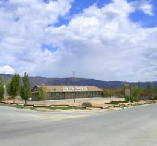
55050 Us Highway 371
576-060-026
1.74 ACRES NET IN PAR 3 PM 074/097 PM 9942
Restaurantbuilding
Riverside
C1CP
California
B and X Area of moderate flood hazard, usually the area between the limits of the 100-year and 500-year floods.
3
2024
1.74 AC
2025
Riverside Outlying
044407
Inland Empire (California)
3,840 SF
Riverside-San Bernardino-Ontario, CA
NEARBY LISTINGS FOR SALE OR LEASE
-
-
View all Anza listings for sale on LoopNet.com
DEMOGRAPHICS near 55050 Us Highway 371
1 mile
3 mile
5 mile
2025 Total Population
113
1,486
2,664
2030 Population
108
1,408
2,539
Pop Growth 2025-2030
(4.42%)
(5.25%)
(4.69%)
Average Age
44
44
44
2025 Total Households
44
569
1,025
HH Growth 2025-2030
(6.82%)
(6.15%)
(5.56%)
Median Household Inc
$43,749
$55,555
$56,922
Avg Household Size
2.40
2.50
2.50
2025 Avg HH Vehicles
2.00
2.00
2.00
Median Home Value
$364,999
$393,461
$364,883
Median Year Built
1985
1984
1985
Nearby Places
Map Layers
Map Styles
 Street
 Aerial
Layers
 Traffic
 Biking
Places
Listings with unknown addresses are not visible on the map
- Restaurants
- Banks
- Shops
- Fitness
- Groceries
PUBLIC TRANSPORTATION
AIRPORT
Palm Springs International
Drive
Walk
Distance
Palm Springs International
64 min
42.9 mi
SALE & LEASE HISTORY
LISTING DATE
SALE/LEASE

Nov 07, 2024
For Sale
Mar 17, 2023
For Sale
Nearby Properties
Address
Land Use
TOTAL SIZE
Lot Size
Zoning
Address
Land Use
TOTAL SIZE
Lot Size
Zoning
12,935 SF
3.53 AC
A1212
Address
Land Use
TOTAL SIZE
Lot Size
Zoning
9,100 SF
1.31 AC
Address
Land Use
TOTAL SIZE
Lot Size
Zoning
1,560 SF
0.83 AC
CPS
Address
Land Use
TOTAL SIZE
Lot Size
Zoning
5,040 SF
2.33 AC
RR
Address
Land Use
TOTAL SIZE
Lot Size
Zoning
5,040 SF
1.36 AC
RR
Address
Land Use
TOTAL SIZE
Lot Size
Zoning
8,692 SF
0.80 AC
CPS
Address
Land Use
TOTAL SIZE
Lot Size
Zoning
4,500 SF
0.91 AC
MM
Address
Land Use
TOTAL SIZE
Lot Size
Zoning
1,032 SF
20 AC
AL
Address
Land Use
TOTAL SIZE
Lot Size
Zoning
3,200 SF
7.76 AC
MIX
Address
Land Use
TOTAL SIZE
Lot Size
Zoning
1,716 SF
0.84 AC
CPS
Address
Land Use
TOTAL SIZE
Lot Size
Zoning
1,680 SF
0.35 AC
CPS
Address
Land Use
TOTAL SIZE
Lot Size
Zoning
52.03 AC
RR
Address
Land Use
TOTAL SIZE
Lot Size
Zoning
2,514 SF
10.36 AC
RR10
Address
Land Use
TOTAL SIZE
Lot Size
Zoning
2,489 SF
43.43 AC
RR
Address
Land Use
TOTAL SIZE
Lot Size
Zoning
8,499 SF
9.25 AC
CPS
Address
Land Use
TOTAL SIZE
Lot Size
Zoning
2,480 SF
20 AC
RR212
Address
Land Use
TOTAL SIZE
Lot Size
Zoning
5,098 SF
2.27 AC
RR212
Address
Land Use
TOTAL SIZE
Lot Size
Zoning
1,866 SF
0.37 AC
CPS
Address
Land Use
TOTAL SIZE
Lot Size
Zoning
9.56 AC
MSC
Address
Land Use
TOTAL SIZE
Lot Size
Zoning
1,656 SF
10.36 AC
RR10
Address
Land Use
TOTAL SIZE
Lot Size
Zoning
3,876 SF
40.66 AC
RR20
Address
Land Use
TOTAL SIZE
Lot Size
Zoning
3,152 SF
5 AC
RR
Address
Land Use
TOTAL SIZE
Lot Size
Zoning
3,960 SF
1.07 AC
CPS
Address
Land Use
TOTAL SIZE
Lot Size
Zoning
3,471 SF
160 AC
A110
Address
Land Use
TOTAL SIZE
Lot Size
Zoning
39.79 AC
RR5
Address
Land Use
TOTAL SIZE
Lot Size
Zoning
37.80 AC
RR5
Address
Land Use
TOTAL SIZE
Lot Size
Zoning
2,942 SF
20 AC
RR
The World's #1 Commercial Real Estate Marketplace
Connect with us
© 2026 CoStar Group
The information above has been obtained from sources believed reliable. While we do not doubt its accuracy we have not verified it and make no guarantee, warranty or representation about it. It is your responsibility to independently confirm its accuracy and completeness. Any projections, opinions, assumptions, or estimates used are for example only and do not represent the current or future performance of the property. The value of this transaction to you depends on tax and other factors which should be evaluated by your tax, financial, and legal advisors. You and your advisors should conduct a careful, independent investigation of the property to determine to your satisfaction the suitability of the property for your needs.