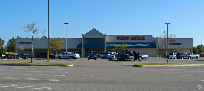
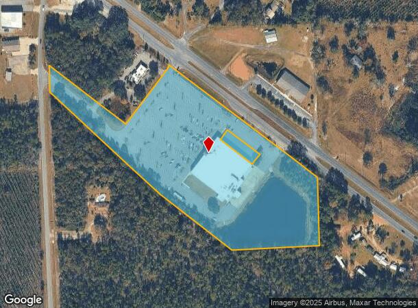
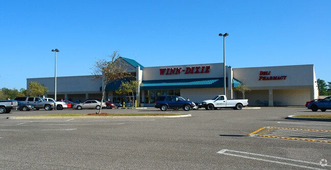
Property Record
550969 Us Highway 1, Hilliard, FL 32046
NEARBY LISTINGS FOR SALE OR LEASE
Property Detail
550969 Us Highway 1
Jacksonville, FL
Dunn Survey
15-3N-24-2320-0021-0020
PT OF LOTS 21 & 22 & PT OF NW1/4 OF SW1/4 OF SEC 15-3N-24E IN OR 970/848 ESMT PT OR 781/1176 DUNN SURVEY
Supermarket
Nassau
X
Florida
12089C0145F
21
2025
12.98 AC
2025
Nassau County
050401
Jacksonville (Florida)
43,822 SF
DEMOGRAPHICS near 550969 Us Highway 1
1 Mile
3 Mile
5 Mile
2024 Total Population
785
5,108
5,841
2029 Population
952
6,137
7,007
Pop Growth 2024-2029
+ 21.27%
+ 20.14%
+ 19.96%
Average Age
40
39
40
2024 Total Households
294
1,887
2,160
HH Growth 2024-2029
+ 22.45%
+ 21.30%
+ 21.16%
Median Household Inc
$72,091
$68,384
$68,626
Avg Household Size
2.70
2.70
2.70
2024 Avg HH Vehicles
3.00
2.00
2.00
Median Home Value
$281,883
$253,711
$253,714
Median Year Built
1998
1991
1991
Nearby Places
Map Layers
Map Styles
 Street
 Aerial
- Restaurants
- Banks
- Shops
- Fitness
- Groceries
PUBLIC TRANSPORTATION
AIRPORT
Jacksonville International
DRIVE
WALK
Distance
Jacksonville International
37 min
24.0 mi
Freight Ports
Jacksonville Port
DRIVE
WALK
Distance
Jacksonville Port
46 min
30.9 mi
Nearby Properties
Address
Land Use
TOTAL SIZE
Lot Size
Zoning
Address
Land Use
TOTAL SIZE
Lot Size
Zoning
126,358 SF
23.72 AC
R-2
Address
Land Use
TOTAL SIZE
Lot Size
Zoning
97,842 SF
37.75 AC
R-2
Address
Land Use
TOTAL SIZE
Lot Size
Zoning
116,618 SF
10.60 AC
R-3
Address
Land Use
TOTAL SIZE
Lot Size
Zoning
116,334 SF
18 AC
A-1
Address
Land Use
TOTAL SIZE
Lot Size
Zoning
147.27 AC
PUD
Address
Land Use
TOTAL SIZE
Lot Size
Zoning
23,587 SF
14 AC
OR
Address
Land Use
TOTAL SIZE
Lot Size
Zoning
40,782 SF
5.09 AC
C-1 - HILL
Address
Land Use
TOTAL SIZE
Lot Size
Zoning
25,583 SF
3.02 AC
R-2
Address
Land Use
TOTAL SIZE
Lot Size
Zoning
18,040 SF
53.79 AC
R-1 - HILL
Address
Land Use
TOTAL SIZE
Lot Size
Zoning
12,550 SF
4.50 AC
CI
Address
Land Use
TOTAL SIZE
Lot Size
Zoning
9,844 SF
6.50 AC
A-1
Address
Land Use
TOTAL SIZE
Lot Size
Zoning
47,138 SF
26.21 AC
R-1 - HILL
Address
Land Use
TOTAL SIZE
Lot Size
Zoning
35,715 SF
6.49 AC
C-1 - HILL
Address
Land Use
TOTAL SIZE
Lot Size
Zoning
11,556 SF
1.30 AC
R-3
Address
Land Use
TOTAL SIZE
Lot Size
Zoning
12,432 SF
6.11 AC
R-3
Address
Land Use
TOTAL SIZE
Lot Size
Zoning
7,101 SF
1.01 AC
R-2
Address
Land Use
TOTAL SIZE
Lot Size
Zoning
10,324 SF
1.20 AC
R-2
Address
Land Use
TOTAL SIZE
Lot Size
Zoning
9,100 SF
1.11 AC
C-1 - HILL
Address
Land Use
TOTAL SIZE
Lot Size
Zoning
9,000 SF
1.67 AC
C-1 - HILL
Address
Land Use
TOTAL SIZE
Lot Size
Zoning
8,080 SF
4.84 AC
C-1 - HILL
Address
Land Use
TOTAL SIZE
Lot Size
Zoning
11,643 SF
57.31 AC
OR
Address
Land Use
TOTAL SIZE
Lot Size
Zoning
8,397 SF
1.15 AC
R-3
Address
Land Use
TOTAL SIZE
Lot Size
Zoning
16,064 SF
2.04 AC
C-1 - HILL
Address
Land Use
TOTAL SIZE
Lot Size
Zoning
27,087 SF
4.05 AC
R-3
Address
Land Use
TOTAL SIZE
Lot Size
Zoning
10,580 SF
20.95 AC
IW
Address
Land Use
TOTAL SIZE
Lot Size
Zoning
7,157 SF
1.82 AC
R-3
Address
Land Use
TOTAL SIZE
Lot Size
Zoning
12,802 SF
0.86 AC
R-3
Address
Land Use
TOTAL SIZE
Lot Size
Zoning
8,613 SF
1.71 AC
R-2
Address
Land Use
TOTAL SIZE
Lot Size
Zoning
3,090 SF
1.51 AC
OR
The World's #1 Commercial Real Estate Marketplace
Connect with us
© 2026 CoStar Group
The information above has been obtained from sources believed reliable. While we do not doubt its accuracy we have not verified it and make no guarantee, warranty or representation about it. It is your responsibility to independently confirm its accuracy and completeness. Any projections, opinions, assumptions, or estimates used are for example only and do not represent the current or future performance of the property. The value of this transaction to you depends on tax and other factors which should be evaluated by your tax, financial, and legal advisors. You and your advisors should conduct a careful, independent investigation of the property to determine to your satisfaction the suitability of the property for your needs.