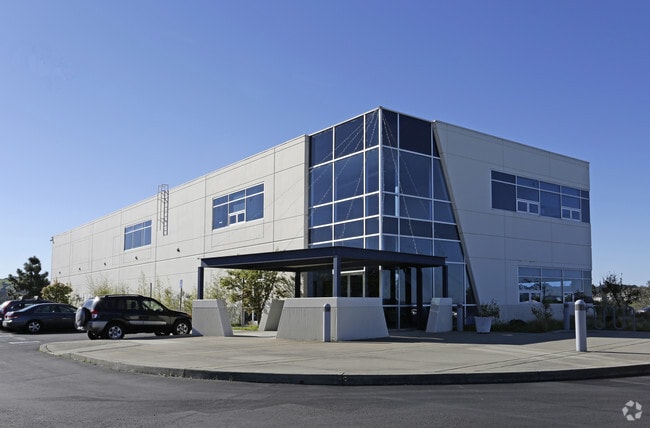
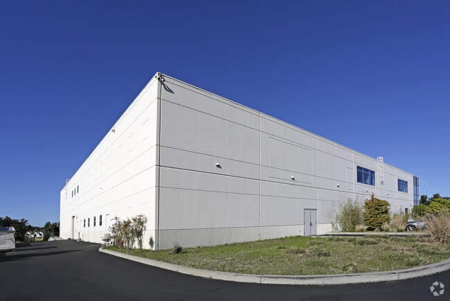
Property Record
551 Linus Pauling Dr, Hercules, CA 94547

Property Detail
551 Linus Pauling Dr
Oakland-Fremont-Berkeley, CA
TRACT 6212 LOT 18 EX MR
404-183-005-2
CONTRA COSTA
Industrialpark
California
B and X Area of moderate flood hazard, usually the area between the limits of the 100-year and 500-year floods.
18
2025
3.56 AC
2025
Martinez/Pacheco/Hercules
392300
East Bay/Oakland
34,873 SF
NEARBY LISTINGS FOR SALE OR LEASE
-
-
View all Hercules listings for sale on LoopNet.com
DEMOGRAPHICS near 551 Linus Pauling Dr
1 mile
3 mile
5 mile
2025 Total Population
13,545
61,001
128,844
2030 Population
13,715
61,439
129,664
Pop Growth 2025-2030
+ 1.26%
+ 0.72%
+ 0.64%
Average Age
41
43
42
2025 Total Households
4,628
20,809
44,558
HH Growth 2025-2030
+ 1.10%
+ 0.68%
+ 0.61%
Median Household Inc
$130,024
$120,457
$111,016
Avg Household Size
2.90
2.90
2.80
2025 Avg HH Vehicles
2.00
2.00
2.00
Median Home Value
$752,413
$735,676
$725,345
Median Year Built
1998
1978
1976
Nearby Places
Map Layers
Map Styles
 Street
 Aerial
Layers
 Traffic
 Biking
Places
Listings with unknown addresses are not visible on the map
- Restaurants
- Banks
- Shops
- Fitness
- Groceries
PUBLIC TRANSPORTATION
COMMUTER RAIL
Drive
Walk
Distance
17 min
9.9 mi
AIRPORT
Metro Oakland International
Drive
Walk
Distance
Metro Oakland International
40 min
28.4 mi
San Francisco International
Drive
Walk
Distance
San Francisco International
52 min
36.0 mi
Freight Ports
Port of Richmond
Drive
Walk
Distance
Port of Richmond
25 min
14.1 mi
Nearby Properties
Address
Land Use
TOTAL SIZE
Lot Size
Zoning
Address
Land Use
TOTAL SIZE
Lot Size
Zoning
213.58 AC
HI
Address
Land Use
TOTAL SIZE
Lot Size
Zoning
67.14 AC
HI
Address
Land Use
TOTAL SIZE
Lot Size
Zoning
76.36 AC
HI
Address
Land Use
TOTAL SIZE
Lot Size
Zoning
44.93 AC
HI
Address
Land Use
TOTAL SIZE
Lot Size
Zoning
268,936 SF
2.20 AC
Address
Land Use
TOTAL SIZE
Lot Size
Zoning
49.85 AC
HI
Address
Land Use
TOTAL SIZE
Lot Size
Zoning
179,961 SF
1.05 AC
Address
Land Use
TOTAL SIZE
Lot Size
Zoning
267,304 SF
1.87 AC
Address
Land Use
TOTAL SIZE
Lot Size
Zoning
135,907 SF
32.16 AC
Address
Land Use
TOTAL SIZE
Lot Size
Zoning
14,722 SF
5.69 AC
Address
Land Use
TOTAL SIZE
Lot Size
Zoning
95,850 SF
6.38 AC
Address
Land Use
TOTAL SIZE
Lot Size
Zoning
96,750 SF
6.54 AC
Address
Land Use
TOTAL SIZE
Lot Size
Zoning
61,875 SF
3.62 AC
Address
Land Use
TOTAL SIZE
Lot Size
Zoning
154,275 SF
7.98 AC
Address
Land Use
TOTAL SIZE
Lot Size
Zoning
6,440 SF
8.14 AC
Address
Land Use
TOTAL SIZE
Lot Size
Zoning
6,752 SF
3.60 AC
Address
Land Use
TOTAL SIZE
Lot Size
Zoning
81,296 SF
6.94 AC
Address
Land Use
TOTAL SIZE
Lot Size
Zoning
69,184 SF
4.68 AC
Address
Land Use
TOTAL SIZE
Lot Size
Zoning
2,969 SF
3.43 AC
Address
Land Use
TOTAL SIZE
Lot Size
Zoning
124,080 SF
9.78 AC
Address
Land Use
TOTAL SIZE
Lot Size
Zoning
79,121 SF
2.23 AC
Address
Land Use
TOTAL SIZE
Lot Size
Zoning
97,181 SF
11.69 AC
Address
Land Use
TOTAL SIZE
Lot Size
Zoning
56,933 SF
4.63 AC
Address
Land Use
TOTAL SIZE
Lot Size
Zoning
511.30 AC
HI
Address
Land Use
TOTAL SIZE
Lot Size
Zoning
60,654 SF
5.29 AC
Address
Land Use
TOTAL SIZE
Lot Size
Zoning
61.60 AC
Address
Land Use
TOTAL SIZE
Lot Size
Zoning
15,208 SF
6.71 AC
Address
Land Use
TOTAL SIZE
Lot Size
Zoning
227.71 AC
HI
Address
Land Use
TOTAL SIZE
Lot Size
Zoning
55,943 SF
6.40 AC
Address
Land Use
TOTAL SIZE
Lot Size
Zoning
3,549 SF
2.17 AC
The World's #1 Commercial Real Estate Marketplace
Connect with us
© 2026 CoStar Group
The information above has been obtained from sources believed reliable. While we do not doubt its accuracy we have not verified it and make no guarantee, warranty or representation about it. It is your responsibility to independently confirm its accuracy and completeness. Any projections, opinions, assumptions, or estimates used are for example only and do not represent the current or future performance of the property. The value of this transaction to you depends on tax and other factors which should be evaluated by your tax, financial, and legal advisors. You and your advisors should conduct a careful, independent investigation of the property to determine to your satisfaction the suitability of the property for your needs.