Property Record
551 Lone Pine Blvd, The Dalles, OR 97058
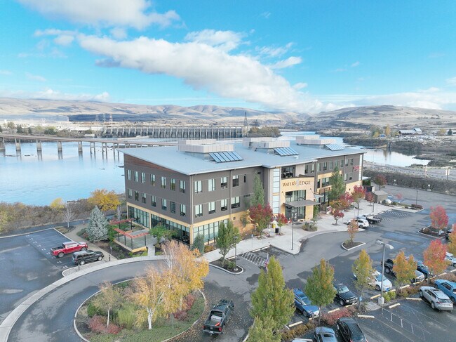
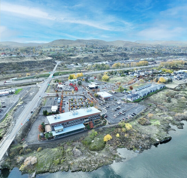
Property Detail
551 Lone Pine Blvd
The Dalles, OR
SECTION 36 TOWNSHIP 2N RANGE 13E QUARTER PRCL 400 MAPTAX LOT: 02N13 E36 00400 00
15496
Wasco
Taxexempt
Oregon
CR RECREAT
1
0
3.01 AC
2025
Oregon East Area
970100
Other Market Areas
NEARBY LISTINGS FOR SALE OR LEASE
DEMOGRAPHICS near 551 Lone Pine Blvd
1 mile
3 mile
5 mile
2025 Total Population
1,426
11,313
18,715
2030 Population
1,400
11,132
18,374
Pop Growth 2025-2030
(1.82%)
(1.60%)
(1.82%)
Average Age
44
41
41
2025 Total Households
567
4,371
7,212
HH Growth 2025-2030
(2.12%)
(1.85%)
(2.05%)
Median Household Inc
$56,349
$68,839
$63,922
Avg Household Size
2.30
2.40
2.50
2025 Avg HH Vehicles
2.00
2.00
2.00
Median Home Value
$429,358
$395,589
$373,693
Median Year Built
1977
1959
1969
Nearby Places
Map Layers
Map Styles
 Street
 Aerial
Layers
 Traffic
 Biking
Places
Listings with unknown addresses are not visible on the map
- Restaurants
- Banks
- Shops
- Fitness
- Groceries
SALE & LEASE HISTORY
LISTING DATE
SALE/LEASE

Dec 01, 2025
For Sale
Nearby Properties
Address
Land Use
TOTAL SIZE
Lot Size
Zoning
Address
Land Use
TOTAL SIZE
Lot Size
Zoning
Address
Land Use
TOTAL SIZE
Lot Size
Zoning
5.52 AC
CG GENERAL
Address
Land Use
TOTAL SIZE
Lot Size
Zoning
12.37 AC
RL
Address
Land Use
TOTAL SIZE
Lot Size
Zoning
Address
Land Use
TOTAL SIZE
Lot Size
Zoning
3.74 AC
NC NBRHD C
Address
Land Use
TOTAL SIZE
Lot Size
Zoning
3.49 AC
CG GENERAL
Address
Land Use
TOTAL SIZE
Lot Size
Zoning
4.13 AC
CG GENERAL
Address
Land Use
TOTAL SIZE
Lot Size
Zoning
Address
Land Use
TOTAL SIZE
Lot Size
Zoning
Address
Land Use
TOTAL SIZE
Lot Size
Zoning
130,200 SF
Address
Land Use
TOTAL SIZE
Lot Size
Zoning
7.23 AC
RH
Address
Land Use
TOTAL SIZE
Lot Size
Zoning
2.02 AC
CG GENERAL
Address
Land Use
TOTAL SIZE
Lot Size
Zoning
0.52 AC
CBC CENTRA
Address
Land Use
TOTAL SIZE
Lot Size
Zoning
0.49 AC
Address
Land Use
TOTAL SIZE
Lot Size
Zoning
6.40 AC
I
Address
Land Use
TOTAL SIZE
Lot Size
Zoning
1.65 AC
CG
Address
Land Use
TOTAL SIZE
Lot Size
Zoning
1.63 AC
CG GENERAL
Address
Land Use
TOTAL SIZE
Lot Size
Zoning
4.37 AC
Address
Land Use
TOTAL SIZE
Lot Size
Zoning
9.38 AC
A1 EXCLUSI
Address
Land Use
TOTAL SIZE
Lot Size
Zoning
0.41 AC
RL
Address
Land Use
TOTAL SIZE
Lot Size
Zoning
1.56 AC
NC NBRHD C
Address
Land Use
TOTAL SIZE
Lot Size
Zoning
2.54 AC
CG GENERAL
Address
Land Use
TOTAL SIZE
Lot Size
Zoning
Address
Land Use
TOTAL SIZE
Lot Size
Zoning
0.67 AC
CBC CENTRA
Address
Land Use
TOTAL SIZE
Lot Size
Zoning
1.67 AC
CG
Address
Land Use
TOTAL SIZE
Lot Size
Zoning
Address
Land Use
TOTAL SIZE
Lot Size
Zoning
3.35 AC
RL
Address
Land Use
TOTAL SIZE
Lot Size
Zoning
45,552 SF
429.85 AC
The World's #1 Commercial Real Estate Marketplace
Connect with us
© 2026 CoStar Group
The information above has been obtained from sources believed reliable. While we do not doubt its accuracy we have not verified it and make no guarantee, warranty or representation about it. It is your responsibility to independently confirm its accuracy and completeness. Any projections, opinions, assumptions, or estimates used are for example only and do not represent the current or future performance of the property. The value of this transaction to you depends on tax and other factors which should be evaluated by your tax, financial, and legal advisors. You and your advisors should conduct a careful, independent investigation of the property to determine to your satisfaction the suitability of the property for your needs.