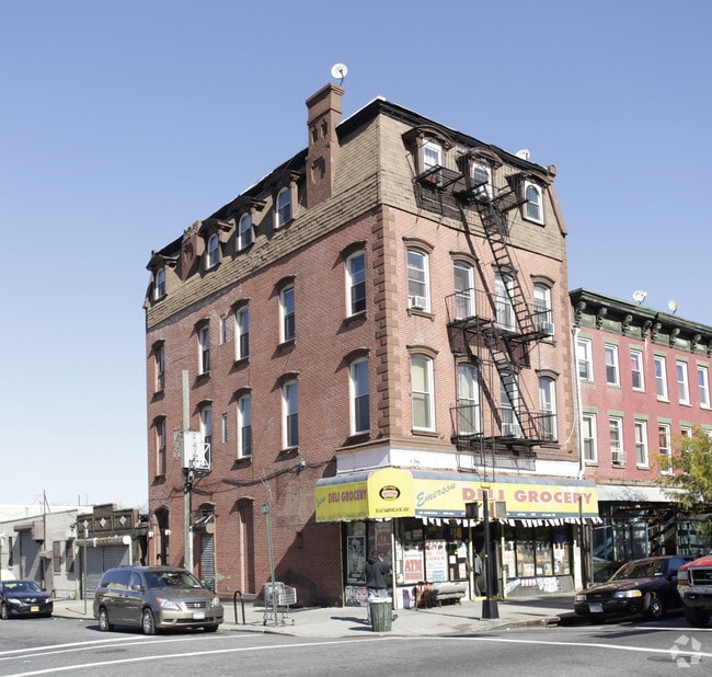
Property Record
551 Myrtle Ave, Brooklyn, NY 11205
NEARBY LISTINGS FOR SALE OR LEASE
Property Detail
551 Myrtle Ave
01895-0073
DOCID-2014112600064001
Commercialofficeresidentialmixeduse
Kings
X
New York
3604970204F
73
2024
0.06 AC
2025
North Brooklyn
019100
Long Island (New York)
7,635 SF
New York-Jersey City-White Plains, NY-NJ
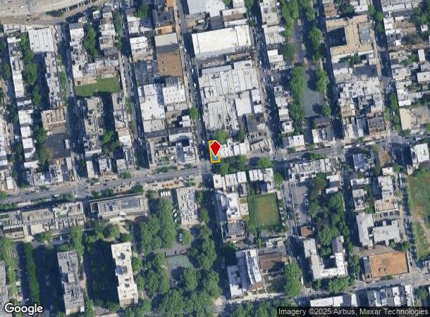
DEMOGRAPHICS near 551 Myrtle Ave
1 Mile
3 Mile
5 Mile
2024 Total Population
186,040
1,330,116
2,855,693
2029 Population
177,763
1,258,356
2,680,591
Pop Growth 2024-2029
(4.45%)
(5.40%)
(6.13%)
Average Age
33
38
38
2024 Total Households
65,622
554,438
1,175,070
HH Growth 2024-2029
(5.10%)
(5.84%)
(6.36%)
Median Household Inc
$67,619
$83,589
$84,466
Avg Household Size
2.70
2.30
2.30
2024 Avg HH Vehicles
.00
.00
.00
Median Home Value
$933,556
$1,012,675
$881,740
Median Year Built
1951
1948
1949
Nearby Places
Map Layers
Map Styles
 Street
 Aerial
- Restaurants
- Banks
- Shops
- Fitness
- Groceries
PUBLIC TRANSPORTATION
TRANSIT/SUBWAY
Classon Avenue (G - New York MTA Subway (The Subway))
DRIVE
WALK
Distance
Classon Avenue (G - New York MTA Subway (The Subway))
3 min
9 min
0.5 mi
Clinton-Washington Avenues (G Line) (G - New York MTA Subway (The Subway))
DRIVE
WALK
Distance
Clinton-Washington Avenues (G Line) (G - New York MTA Subway (The Subway))
13 min
0.7 mi
Myrtle-Willoughby Avenues (G - New York MTA Subway (The Subway))
DRIVE
WALK
Distance
Myrtle-Willoughby Avenues (G - New York MTA Subway (The Subway))
14 min
0.8 mi
Bedford-Nostrand Avenues (G - New York MTA Subway (The Subway))
DRIVE
WALK
Distance
Bedford-Nostrand Avenues (G - New York MTA Subway (The Subway))
15 min
0.8 mi
Clinton-Washington Avenues (A,C Line) (A - New York MTA Subway (The Subway), C - New York MTA Subway (The Subway))
DRIVE
WALK
Distance
Clinton-Washington Avenues (A,C Line) (A - New York MTA Subway (The Subway), C - New York MTA Subway (The Subway))
18 min
1.0 mi
COMMUTER RAIL
Long Island City Station (Hempstead Branch - Long Island Rail Road)
DRIVE
WALK
Distance
Long Island City Station (Hempstead Branch - Long Island Rail Road)
16 min
6.3 mi
AIRPORT
John F Kennedy International
DRIVE
WALK
Distance
John F Kennedy International
23 min
15.8 mi
Newark Liberty International
DRIVE
WALK
Distance
Newark Liberty International
28 min
15.9 mi
Westchester County
DRIVE
WALK
Distance
Westchester County
48 min
37.4 mi
SALE & LEASE HISTORY
LISTING DATE
SALE/LEASE

Feb 23, 2017
For Lease
Nearby Properties
Address
Land Use
TOTAL SIZE
Lot Size
Zoning
Address
Land Use
TOTAL SIZE
Lot Size
Zoning
8,462,176 SF
61.41 AC
R7-2
Address
Land Use
TOTAL SIZE
Lot Size
Zoning
2,812,739 SF
2.10 AC
C5-3
Address
Land Use
TOTAL SIZE
Lot Size
Zoning
1,104,505 SF
2.32 AC
C4-7
Address
Land Use
TOTAL SIZE
Lot Size
Zoning
1,636,000 SF
1.09 AC
C6-4
Address
Land Use
TOTAL SIZE
Lot Size
Zoning
940,000 SF
1.44 AC
C6-2
Address
Land Use
TOTAL SIZE
Lot Size
Zoning
7,058,736 SF
147.61 AC
M3-1
Address
Land Use
TOTAL SIZE
Lot Size
Zoning
869,038 SF
1.53 AC
M1-1
Address
Land Use
TOTAL SIZE
Lot Size
Zoning
1,260,362 SF
4.32 AC
C1-7
Address
Land Use
TOTAL SIZE
Lot Size
Zoning
802,000 SF
1.20 AC
C62A
Address
Land Use
TOTAL SIZE
Lot Size
Zoning
3,122,165 SF
19.02 AC
R7-2
Address
Land Use
TOTAL SIZE
Lot Size
Zoning
2,210,200 SF
2.58 AC
C5-5
Address
Land Use
TOTAL SIZE
Lot Size
Zoning
1,362,190 SF
C5-5
Address
Land Use
TOTAL SIZE
Lot Size
Zoning
1,653,794 SF
3.15 AC
C6-4
Address
Land Use
TOTAL SIZE
Lot Size
Zoning
932,587 SF
1.23 AC
C5-3
Address
Land Use
TOTAL SIZE
Lot Size
Zoning
1,499,568 SF
1.66 AC
C5-5
Address
Land Use
TOTAL SIZE
Lot Size
Zoning
1,617,206 SF
1.23 AC
C5-5
Address
Land Use
TOTAL SIZE
Lot Size
Zoning
2,542,066 SF
174.49 AC
R3-2
Address
Land Use
TOTAL SIZE
Lot Size
Zoning
1,092,665 SF
1.06 AC
C62A
Address
Land Use
TOTAL SIZE
Lot Size
Zoning
1,503,150 SF
20.47 AC
R5
Address
Land Use
TOTAL SIZE
Lot Size
Zoning
1,075,808 SF
1.12 AC
C5-5
Address
Land Use
TOTAL SIZE
Lot Size
Zoning
1,141,276 SF
1.21 AC
C5-5
Address
Land Use
TOTAL SIZE
Lot Size
Zoning
393.54 AC
PARK
Address
Land Use
TOTAL SIZE
Lot Size
Zoning
945,425 SF
21.70 AC
PARK
Address
Land Use
TOTAL SIZE
Lot Size
Zoning
1,289,243 SF
1.14 AC
C5-5
Address
Land Use
TOTAL SIZE
Lot Size
Zoning
2,948,300 SF
27.71 AC
R7-2
Address
Land Use
TOTAL SIZE
Lot Size
Zoning
577,381 SF
3.19 AC
R6
Address
Land Use
TOTAL SIZE
Lot Size
Zoning
890,142 SF
2.22 AC
R7-1
Address
Land Use
TOTAL SIZE
Lot Size
Zoning
1,079,361 SF
1.07 AC
C5-3
Address
Land Use
TOTAL SIZE
Lot Size
Zoning
385,831 SF
0.83 AC
C6-3
Address
Land Use
TOTAL SIZE
Lot Size
Zoning
943,802 SF
0.97 AC
C6-9
The World's #1 Commercial Real Estate Marketplace
Connect with us
© 2026 CoStar Group
The information above has been obtained from sources believed reliable. While we do not doubt its accuracy we have not verified it and make no guarantee, warranty or representation about it. It is your responsibility to independently confirm its accuracy and completeness. Any projections, opinions, assumptions, or estimates used are for example only and do not represent the current or future performance of the property. The value of this transaction to you depends on tax and other factors which should be evaluated by your tax, financial, and legal advisors. You and your advisors should conduct a careful, independent investigation of the property to determine to your satisfaction the suitability of the property for your needs.