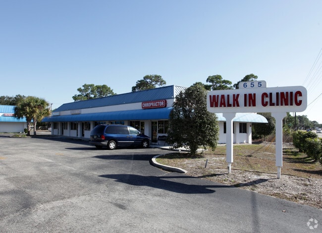
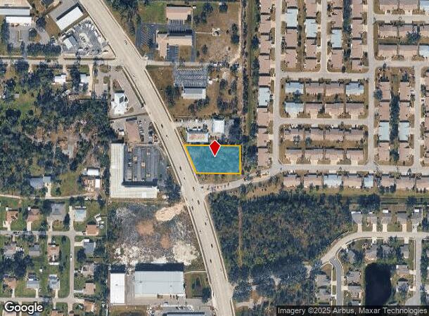
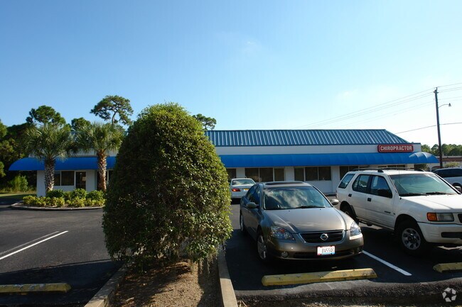
Property Record
551 N Indiana Ave, Englewood, FL 34223
NEARBY LISTINGS FOR SALE OR LEASE
Property Detail
551 N Indiana Ave
North Port-Sarasota-Bradenton, FL
Englewood Plat Of
0496-08-0004
THE SLY 137.15 FT OF NLY 274.15 FT OF SLY 414.43 FT OF THAT PART OF BLK 48 LYING ELY OF SR 775, PLAT OF ENGLEWOOD
Commercialacreage
Sarasota
X
Florida
12115C0451G
48
2024
0.77 AC
2025
Sarasota Outlying
002604
Tampa/St Petersburg
DEMOGRAPHICS near 551 N Indiana Ave
1 Mile
3 Mile
5 Mile
2024 Total Population
5,037
19,257
43,792
2029 Population
5,805
22,661
52,018
Pop Growth 2024-2029
+ 15.25%
+ 17.68%
+ 18.78%
Average Age
60
60
61
2024 Total Households
2,648
10,000
22,534
HH Growth 2024-2029
+ 15.26%
+ 17.71%
+ 18.95%
Median Household Inc
$51,319
$59,601
$66,769
Avg Household Size
1.80
1.80
1.90
2024 Avg HH Vehicles
1.00
2.00
2.00
Median Home Value
$254,145
$337,625
$327,641
Median Year Built
1982
1982
1987
Nearby Places
Map Layers
Map Styles
 Street
 Aerial
- Restaurants
- Banks
- Shops
- Fitness
- Groceries
PUBLIC TRANSPORTATION
AIRPORT
Punta Gorda
DRIVE
WALK
Distance
Punta Gorda
51 min
30.8 mi
Freight Ports
Port Manatee
DRIVE
WALK
Distance
Port Manatee
68 min
52.2 mi
Nearby Properties
Address
Land Use
TOTAL SIZE
Lot Size
Zoning
Address
Land Use
TOTAL SIZE
Lot Size
Zoning
219.10 AC
V
Address
Land Use
TOTAL SIZE
Lot Size
Zoning
95,649 SF
10.41 AC
OPI
Address
Land Use
TOTAL SIZE
Lot Size
Zoning
73,356 SF
8.98 AC
GU
Address
Land Use
TOTAL SIZE
Lot Size
Zoning
30,565 SF
136.67 AC
GU
Address
Land Use
TOTAL SIZE
Lot Size
Zoning
304.41 AC
PUD
Address
Land Use
TOTAL SIZE
Lot Size
Zoning
63,480 SF
6.22 AC
RMF3
Address
Land Use
TOTAL SIZE
Lot Size
Zoning
112,350 SF
2.84 AC
CG
Address
Land Use
TOTAL SIZE
Lot Size
Zoning
103,161 SF
2.54 AC
ILW
Address
Land Use
TOTAL SIZE
Lot Size
Zoning
111,505 SF
9.53 AC
CG
Address
Land Use
TOTAL SIZE
Lot Size
Zoning
95,900 SF
5.56 AC
RMF3
Address
Land Use
TOTAL SIZE
Lot Size
Zoning
70,165 SF
22.18 AC
CG
Address
Land Use
TOTAL SIZE
Lot Size
Zoning
136.72 AC
OUC
Address
Land Use
TOTAL SIZE
Lot Size
Zoning
71,462 SF
24.99 AC
RE1
Address
Land Use
TOTAL SIZE
Lot Size
Zoning
2,495 SF
6.97 AC
RMH
Address
Land Use
TOTAL SIZE
Lot Size
Zoning
89,501 SF
6.52 AC
CG
Address
Land Use
TOTAL SIZE
Lot Size
Zoning
50,672 SF
77.41 AC
RMF1
Address
Land Use
TOTAL SIZE
Lot Size
Zoning
4,219 SF
69.48 AC
GU
Address
Land Use
TOTAL SIZE
Lot Size
Zoning
42,228 SF
9.24 AC
RE1
Address
Land Use
TOTAL SIZE
Lot Size
Zoning
72,168 SF
7.11 AC
CG
Address
Land Use
TOTAL SIZE
Lot Size
Zoning
1,459 SF
11.21 AC
RSF4
Address
Land Use
TOTAL SIZE
Lot Size
Zoning
38,753 SF
8.78 AC
OPI
Address
Land Use
TOTAL SIZE
Lot Size
Zoning
44,594 SF
5.70 AC
CG
Address
Land Use
TOTAL SIZE
Lot Size
Zoning
35,351 SF
7.44 AC
CG
Address
Land Use
TOTAL SIZE
Lot Size
Zoning
3.13 AC
RE2
Address
Land Use
TOTAL SIZE
Lot Size
Zoning
72,151 SF
5.09 AC
CI
Address
Land Use
TOTAL SIZE
Lot Size
Zoning
93.43 AC
RSF2
Address
Land Use
TOTAL SIZE
Lot Size
Zoning
11,475 SF
3.86 AC
RE2
Address
Land Use
TOTAL SIZE
Lot Size
Zoning
42,955 SF
15.64 AC
OUE1
Address
Land Use
TOTAL SIZE
Lot Size
Zoning
8,448 SF
1.46 AC
RE2
Address
Land Use
TOTAL SIZE
Lot Size
Zoning
14,938 SF
1.63 AC
CG
The World's #1 Commercial Real Estate Marketplace
Connect with us
© 2026 CoStar Group
The information above has been obtained from sources believed reliable. While we do not doubt its accuracy we have not verified it and make no guarantee, warranty or representation about it. It is your responsibility to independently confirm its accuracy and completeness. Any projections, opinions, assumptions, or estimates used are for example only and do not represent the current or future performance of the property. The value of this transaction to you depends on tax and other factors which should be evaluated by your tax, financial, and legal advisors. You and your advisors should conduct a careful, independent investigation of the property to determine to your satisfaction the suitability of the property for your needs.