Property Record
5510 Burnet Rd, Austin, TX 78756
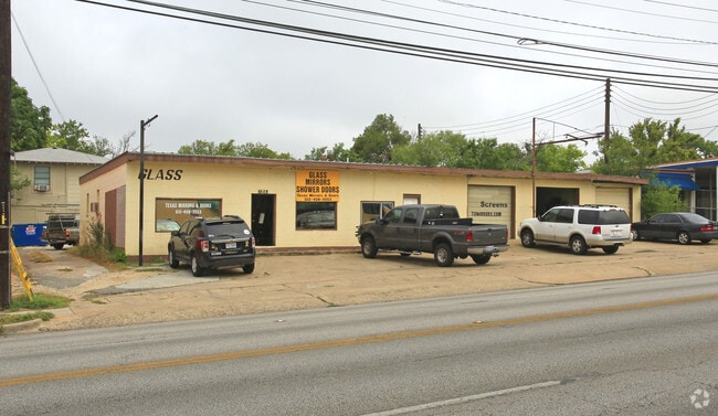

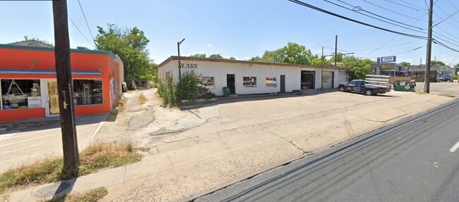

Property Detail
5510 Burnet Rd
Austin-Round Rock-San Marcos, TX
SHOALMONT ADDN AMD LT 2 BLK 1 & LT 13 BLK 1 RSB BLK 1 LOT 2-A
972422
TRAVIS
Warehouse
Texas
2025
0.70 AC
2025
Central
000206
Austin
3,480 SF
NEARBY LISTINGS FOR SALE OR LEASE
DEMOGRAPHICS near 5510 Burnet Rd
1 mile
3 mile
5 mile
2025 Total Population
15,991
155,672
359,347
2030 Population
16,665
163,371
377,360
Pop Growth 2025-2030
+ 4.21%
+ 4.95%
+ 5.01%
Average Age
39
37
37
2025 Total Households
8,219
71,972
160,793
HH Growth 2025-2030
+ 4.99%
+ 5.78%
+ 5.90%
Median Household Inc
$107,311
$82,712
$89,027
Avg Household Size
1.90
2.00
2.10
2025 Avg HH Vehicles
2.00
2.00
2.00
Median Home Value
$824,190
$811,507
$780,214
Median Year Built
1972
1980
1988
Nearby Places
Map Layers
Map Styles
 Street
 Aerial
Transit
 Traffic
 Biking
Places
Listings with unknown addresses are not visible on the map
- Restaurants
- Banks
- Shops
- Fitness
- Groceries
PUBLIC TRANSPORTATION
COMMUTER RAIL
Drive
Walk
Distance
12 min
6.5 mi
AIRPORT
Austin-Bergstrom International
Drive
Walk
Distance
Austin-Bergstrom International
28 min
14.9 mi
SALE & LEASE HISTORY
LISTING DATE
SALE/LEASE

Sep 24, 2019
For Lease
May 23, 2025
For Lease
Jan 16, 2024
For Sale
Dec 06, 2022
For Lease
Dec 05, 2024
For Sale
Nearby Properties
Address
Land Use
TOTAL SIZE
Lot Size
Zoning
Address
Land Use
TOTAL SIZE
Lot Size
Zoning
74.69 AC
Address
Land Use
TOTAL SIZE
Lot Size
Zoning
548,399 SF
23.82 AC
Address
Land Use
TOTAL SIZE
Lot Size
Zoning
623,000 SF
11.78 AC
Address
Land Use
TOTAL SIZE
Lot Size
Zoning
21 AC
Address
Land Use
TOTAL SIZE
Lot Size
Zoning
614,532 SF
66.07 AC
Address
Land Use
TOTAL SIZE
Lot Size
Zoning
552,000 SF
1.21 AC
Address
Land Use
TOTAL SIZE
Lot Size
Zoning
1,234 SF
96.75 AC
Address
Land Use
TOTAL SIZE
Lot Size
Zoning
95.86 AC
Address
Land Use
TOTAL SIZE
Lot Size
Zoning
263,226 SF
1.43 AC
Address
Land Use
TOTAL SIZE
Lot Size
Zoning
973,370 SF
11.26 AC
Address
Land Use
TOTAL SIZE
Lot Size
Zoning
14.55 AC
Address
Land Use
TOTAL SIZE
Lot Size
Zoning
73.48 AC
Address
Land Use
TOTAL SIZE
Lot Size
Zoning
510,500 SF
9.26 AC
Address
Land Use
TOTAL SIZE
Lot Size
Zoning
401,418 SF
4.77 AC
Address
Land Use
TOTAL SIZE
Lot Size
Zoning
Address
Land Use
TOTAL SIZE
Lot Size
Zoning
241,000 SF
0.40 AC
Address
Land Use
TOTAL SIZE
Lot Size
Zoning
241,998 SF
2.42 AC
Address
Land Use
TOTAL SIZE
Lot Size
Zoning
238,650 SF
1.18 AC
Address
Land Use
TOTAL SIZE
Lot Size
Zoning
480,823 SF
18.46 AC
Address
Land Use
TOTAL SIZE
Lot Size
Zoning
322,150 SF
3.83 AC
Address
Land Use
TOTAL SIZE
Lot Size
Zoning
432,032 SF
6.70 AC
Address
Land Use
TOTAL SIZE
Lot Size
Zoning
609,823 SF
3.33 AC
Address
Land Use
TOTAL SIZE
Lot Size
Zoning
346,319 SF
6.53 AC
Address
Land Use
TOTAL SIZE
Lot Size
Zoning
45 AC
Address
Land Use
TOTAL SIZE
Lot Size
Zoning
303,622 SF
5.21 AC
Address
Land Use
TOTAL SIZE
Lot Size
Zoning
425,200 SF
2.49 AC
Address
Land Use
TOTAL SIZE
Lot Size
Zoning
296,378 SF
3.72 AC
Address
Land Use
TOTAL SIZE
Lot Size
Zoning
20.99 AC
Address
Land Use
TOTAL SIZE
Lot Size
Zoning
274,228 SF
4.95 AC
The World's #1 Commercial Real Estate Marketplace
Connect with us
© 2026 CoStar Group
The information above has been obtained from sources believed reliable. While we do not doubt its accuracy we have not verified it and make no guarantee, warranty or representation about it. It is your responsibility to independently confirm its accuracy and completeness. Any projections, opinions, assumptions, or estimates used are for example only and do not represent the current or future performance of the property. The value of this transaction to you depends on tax and other factors which should be evaluated by your tax, financial, and legal advisors. You and your advisors should conduct a careful, independent investigation of the property to determine to your satisfaction the suitability of the property for your needs.