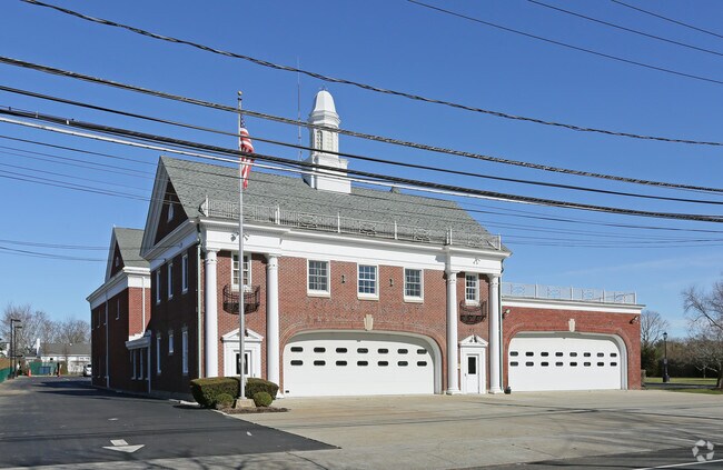
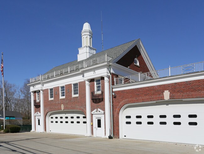
Property Record
55135 Route 25, Southold, NY 11971

NEARBY LISTINGS FOR SALE OR LEASE
-
-
View all Southold listings for sale on LoopNet.com
Property Detail
55135 Route 25
1000-062-00-01-00-019-001
Suffolk
Policefirecivildefense
New York
X
19
36103C0166H
2.60 AC
2024
Eastern Suffolk
2024
Long Island (New York)
170204
Nassau County-Suffolk County, NY
DEMOGRAPHICS near 55135 Route 25
1 Mile
3 Mile
5 Mile
2024 Total Population
2,594
9,036
20,737
2029 Population
2,624
9,347
21,343
Pop Growth 2024-2029
+ 1.16%
+ 3.44%
+ 2.92%
Average Age
48
49
48
2024 Total Households
1,064
3,880
8,863
HH Growth 2024-2029
+ 0.94%
+ 3.38%
+ 2.90%
Median Household Inc
$83,467
$98,324
$95,967
Avg Household Size
2.30
2.30
2.30
2024 Avg HH Vehicles
2.00
2.00
2.00
Median Home Value
$682,739
$741,835
$760,210
Median Year Built
1969
1973
1973
Nearby Places
Map Layers
Map Styles
 Street
 Aerial
- Restaurants
- Banks
- Shops
- Fitness
- Groceries
PUBLIC TRANSPORTATION
COMMUTER RAIL
Southold Station (Greenport Branch - Long Island Rail Road)
DRIVE
WALK
Distance
Southold Station (Greenport Branch - Long Island Rail Road)
1 min
5 min
0.3 mi
Greenport Station (Greenport Branch - Long Island Rail Road)
DRIVE
WALK
Distance
Greenport Station (Greenport Branch - Long Island Rail Road)
9 min
4.5 mi
Freight Ports
Port of New Haven
DRIVE
WALK
Distance
Port of New Haven
172 min
75.3 mi
Nearby Properties
Address
Land Use
TOTAL SIZE
Lot Size
Zoning
Address
Land Use
TOTAL SIZE
Lot Size
Zoning
904 SF
20.30 AC
AA
Address
Land Use
TOTAL SIZE
Lot Size
Zoning
38.11 AC
R-40 RO
Address
Land Use
TOTAL SIZE
Lot Size
Zoning
778 SF
7.68 AC
AA
Address
Land Use
TOTAL SIZE
Lot Size
Zoning
4.12 AC
AA
Address
Land Use
TOTAL SIZE
Lot Size
Zoning
1.62 AC
AA
Address
Land Use
TOTAL SIZE
Lot Size
Zoning
2.30 AC
AA
Address
Land Use
TOTAL SIZE
Lot Size
Zoning
Address
Land Use
TOTAL SIZE
Lot Size
Zoning
1.90 AC
AA
Address
Land Use
TOTAL SIZE
Lot Size
Zoning
1.90 AC
AA
Address
Land Use
TOTAL SIZE
Lot Size
Zoning
8.35 AC
LB R-80
Address
Land Use
TOTAL SIZE
Lot Size
Zoning
0.35 AC
HD
Address
Land Use
TOTAL SIZE
Lot Size
Zoning
3.58 AC
HD
Address
Land Use
TOTAL SIZE
Lot Size
Zoning
0.50 AC
AA
Address
Land Use
TOTAL SIZE
Lot Size
Zoning
0.50 AC
AA
Address
Land Use
TOTAL SIZE
Lot Size
Zoning
0.02 AC
Address
Land Use
TOTAL SIZE
Lot Size
Zoning
2,042 SF
0.46 AC
A
Address
Land Use
TOTAL SIZE
Lot Size
Zoning
2.48 AC
Address
Land Use
TOTAL SIZE
Lot Size
Zoning
0.02 AC
Address
Land Use
TOTAL SIZE
Lot Size
Zoning
17.34 AC
Address
Land Use
TOTAL SIZE
Lot Size
Zoning
12.10 AC
R-80 B
Address
Land Use
TOTAL SIZE
Lot Size
Zoning
3.20 AC
R-80
Address
Land Use
TOTAL SIZE
Lot Size
Zoning
68 AC
R-80
Address
Land Use
TOTAL SIZE
Lot Size
Zoning
Address
Land Use
TOTAL SIZE
Lot Size
Zoning
10.50 AC
R-40
Address
Land Use
TOTAL SIZE
Lot Size
Zoning
4.33 AC
R-40 RO
Address
Land Use
TOTAL SIZE
Lot Size
Zoning
4.33 AC
R-80
Address
Land Use
TOTAL SIZE
Lot Size
Zoning
36.62 AC
R-80
Address
Land Use
TOTAL SIZE
Lot Size
Zoning
72.30 AC
AC R-80
Address
Land Use
TOTAL SIZE
Lot Size
Zoning
6.84 AC
AC
The World's #1 Commercial Real Estate Marketplace
Connect with us
© 2026 CoStar Group
The information above has been obtained from sources believed reliable. While we do not doubt its accuracy we have not verified it and make no guarantee, warranty or representation about it. It is your responsibility to independently confirm its accuracy and completeness. Any projections, opinions, assumptions, or estimates used are for example only and do not represent the current or future performance of the property. The value of this transaction to you depends on tax and other factors which should be evaluated by your tax, financial, and legal advisors. You and your advisors should conduct a careful, independent investigation of the property to determine to your satisfaction the suitability of the property for your needs.