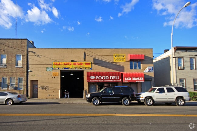
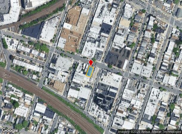
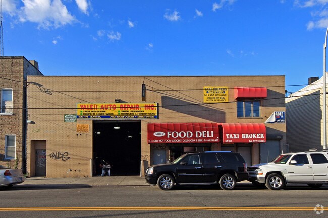
Property Record
5514 37Th Ave, Woodside, NY 11377

NEARBY LISTINGS FOR SALE OR LEASE
Property Detail
5514 37Th Ave
01210-0007
Hitchcocks
Autorepair
Queens
X
New York
3604970093F
7
2024
0.11 AC
2025
Northwest Queens
025500
Long Island (New York)
5,782 SF
New York-Jersey City-White Plains, NY-NJ
DEMOGRAPHICS near 5514 37Th Ave
1 Mile
3 Mile
5 Mile
2024 Total Population
144,465
926,254
2,896,533
2029 Population
136,563
868,734
2,704,600
Pop Growth 2024-2029
(5.47%)
(6.21%)
(6.63%)
Average Age
41
40
40
2024 Total Households
55,750
366,724
1,217,841
HH Growth 2024-2029
(5.61%)
(6.30%)
(6.91%)
Median Household Inc
$69,664
$80,555
$78,663
Avg Household Size
2.50
2.40
2.30
2024 Avg HH Vehicles
1.00
1.00
.00
Median Home Value
$635,155
$751,957
$825,304
Median Year Built
1950
1954
1954
Nearby Places
- Restaurants
- Banks
- Shops
- Fitness
- Groceries
PUBLIC TRANSPORTATION
TRANSIT/SUBWAY
Northern Boulevard (E - New York MTA Subway (The Subway), M - New York MTA Subway (The Subway), R - New York MTA Subway (The Subway))
DRIVE
WALK
Distance
Northern Boulevard (E - New York MTA Subway (The Subway), M - New York MTA Subway (The Subway), R - New York MTA Subway (The Subway))
1 min
4 min
0.2 mi
Woodside-61 Street (7 - New York MTA Subway (The Subway))
DRIVE
WALK
Distance
Woodside-61 Street (7 - New York MTA Subway (The Subway))
2 min
10 min
0.5 mi
65 Street (E - New York MTA Subway (The Subway), M - New York MTA Subway (The Subway), R - New York MTA Subway (The Subway))
DRIVE
WALK
Distance
65 Street (E - New York MTA Subway (The Subway), M - New York MTA Subway (The Subway), R - New York MTA Subway (The Subway))
2 min
10 min
0.5 mi
69 Street (7 - New York MTA Subway (The Subway))
DRIVE
WALK
Distance
69 Street (7 - New York MTA Subway (The Subway))
2 min
13 min
0.7 mi
52 Street (7 - New York MTA Subway (The Subway))
DRIVE
WALK
Distance
52 Street (7 - New York MTA Subway (The Subway))
2 min
13 min
0.7 mi
COMMUTER RAIL
Woodside Station (Babylon Branch - Long Island Rail Road, Far Rockaway Branch - Long Island Rail Road, Hempstead Branch - Long Island Rail Road, Long Beach Branch - Long Island Rail Road, Montauk Branch - Long Island Rail Road, Port Jefferson Branch - Long Island Rail Road, Port Washington Branch - Long Island Rail Road, Ronkonkoma Branch - Long Island Rail Road)
DRIVE
WALK
Distance
Woodside Station (Babylon Branch - Long Island Rail Road, Far Rockaway Branch - Long Island Rail Road, Hempstead Branch - Long Island Rail Road, Long Beach Branch - Long Island Rail Road, Montauk Branch - Long Island Rail Road, Port Jefferson Branch - Long Island Rail Road, Port Washington Branch - Long Island Rail Road, Ronkonkoma Branch - Long Island Rail Road)
2 min
10 min
0.5 mi
Hunterspoint Avenue Station (Hempstead Branch - Long Island Rail Road, Oyster Bay Branch - Long Island Rail Road)
DRIVE
WALK
Distance
Hunterspoint Avenue Station (Hempstead Branch - Long Island Rail Road, Oyster Bay Branch - Long Island Rail Road)
7 min
2.7 mi
AIRPORT
LaGuardia
DRIVE
WALK
Distance
LaGuardia
7 min
2.9 mi
John F Kennedy International
DRIVE
WALK
Distance
John F Kennedy International
19 min
13.0 mi
Newark Liberty International
DRIVE
WALK
Distance
Newark Liberty International
31 min
20.5 mi
Freight Ports
NY - Red Hook Container Terminal
DRIVE
WALK
Distance
NY - Red Hook Container Terminal
17 min
9.3 mi
Nearby Properties
Address
Land Use
TOTAL SIZE
Lot Size
Zoning
Address
Land Use
TOTAL SIZE
Lot Size
Zoning
2,230,742 SF
6.33 AC
R9
Address
Land Use
TOTAL SIZE
Lot Size
Zoning
1,200,000 SF
10.24 AC
R9
Address
Land Use
TOTAL SIZE
Lot Size
Zoning
1,065,915 SF
2.13 AC
M16R10
Address
Land Use
TOTAL SIZE
Lot Size
Zoning
757,439 SF
0.91 AC
C1-9
Address
Land Use
TOTAL SIZE
Lot Size
Zoning
733,747 SF
0.98 AC
R10
Address
Land Use
TOTAL SIZE
Lot Size
Zoning
1,502,532 SF
6.35 AC
R7B
Address
Land Use
TOTAL SIZE
Lot Size
Zoning
714,224 SF
0.70 AC
R8
Address
Land Use
TOTAL SIZE
Lot Size
Zoning
805,287 SF
1 AC
R10
Address
Land Use
TOTAL SIZE
Lot Size
Zoning
772,163 SF
5.24 AC
C4-5X
Address
Land Use
TOTAL SIZE
Lot Size
Zoning
984,760 SF
2.04 AC
M3-1
Address
Land Use
TOTAL SIZE
Lot Size
Zoning
407,259 SF
0.93 AC
C5-2
Address
Land Use
TOTAL SIZE
Lot Size
Zoning
661,538 SF
11.26 AC
R7-2
Address
Land Use
TOTAL SIZE
Lot Size
Zoning
1,359,110 SF
1.89 AC
C5-3
Address
Land Use
TOTAL SIZE
Lot Size
Zoning
527,900 SF
0.57 AC
R10
Address
Land Use
TOTAL SIZE
Lot Size
Zoning
1,292,074 SF
C4-2F
Address
Land Use
TOTAL SIZE
Lot Size
Zoning
334,675 SF
10.24 AC
R9
Address
Land Use
TOTAL SIZE
Lot Size
Zoning
538,454 SF
2.37 AC
R9
Address
Land Use
TOTAL SIZE
Lot Size
Zoning
410,239 SF
0.77 AC
R10
Address
Land Use
TOTAL SIZE
Lot Size
Zoning
234,891 SF
3.17 AC
C4-5X
Address
Land Use
TOTAL SIZE
Lot Size
Zoning
751,223 SF
2.57 AC
R6
Address
Land Use
TOTAL SIZE
Lot Size
Zoning
804,200 SF
5.28 AC
R7-2
Address
Land Use
TOTAL SIZE
Lot Size
Zoning
207.09 AC
PARK
Address
Land Use
TOTAL SIZE
Lot Size
Zoning
882,579 SF
0.51 AC
M16R10
Address
Land Use
TOTAL SIZE
Lot Size
Zoning
684,862 SF
1.65 AC
M3-1
Address
Land Use
TOTAL SIZE
Lot Size
Zoning
648,703 SF
1.45 AC
C28A
Address
Land Use
TOTAL SIZE
Lot Size
Zoning
505,416 SF
M16R10
Address
Land Use
TOTAL SIZE
Lot Size
Zoning
710,860 SF
1.52 AC
M15R9
Address
Land Use
TOTAL SIZE
Lot Size
Zoning
504,420 SF
0.97 AC
R10
Address
Land Use
TOTAL SIZE
Lot Size
Zoning
259,670 SF
0.14 AC
R10
Address
Land Use
TOTAL SIZE
Lot Size
Zoning
948 SF
282.37 AC
PARK
The World's #1 Commercial Real Estate Marketplace
Connect with us
© 2025 CoStar Group
The information above has been obtained from sources believed reliable. While we do not doubt its accuracy we have not verified it and make no guarantee, warranty or representation about it. It is your responsibility to independently confirm its accuracy and completeness. Any projections, opinions, assumptions, or estimates used are for example only and do not represent the current or future performance of the property. The value of this transaction to you depends on tax and other factors which should be evaluated by your tax, financial, and legal advisors. You and your advisors should conduct a careful, independent investigation of the property to determine to your satisfaction the suitability of the property for your needs.