Property Record
5515 Woodbine Rd, Milton, FL 32571


NEARBY LISTINGS FOR SALE OR LEASE
-
-
View all Milton listings for sale on LoopNet.com
Property Detail
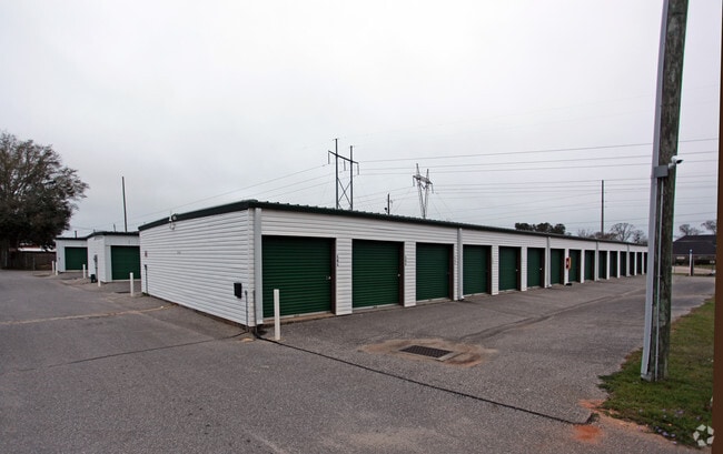
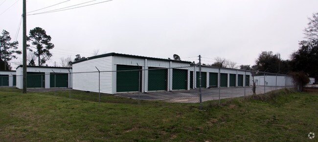
5515 Woodbine Rd
31-2N-29-0000-00605-0000
*DESCRIPTION UPDATE FOR 2023* COM AT SW SEC CORN THN N90*0 E 3963.68 FT THN N0*11E 1323.74 FT CONT 39.14 FT TO S LN OF GULF POWER ESMNT THN N73*0612E 984.27 FT TO POB & CONT 227.15 FT TO W R/W OF WOODBINE RD THN S2*2225E 396.81 FT THN N89* 4444W 350
Publicstorage
Santa Rosa
X
Florida
12113C0293H
2.42 AC
2024
Gonzalez/SW Santa Rosa
2025
Pensacola
010707
Pensacola-Ferry Pass-Brent, FL
34,880 SF
DEMOGRAPHICS near 5515 Woodbine Rd
1 Mile
3 Mile
5 Mile
2024 Total Population
4,633
22,827
37,137
2029 Population
5,321
26,149
42,477
Pop Growth 2024-2029
+ 14.85%
+ 14.55%
+ 14.38%
Average Age
41
39
39
2024 Total Households
1,655
8,050
13,320
HH Growth 2024-2029
+ 15.05%
+ 14.80%
+ 14.65%
Median Household Inc
$92,272
$86,600
$82,127
Avg Household Size
2.80
2.80
2.80
2024 Avg HH Vehicles
2.00
2.00
2.00
Median Home Value
$318,168
$285,834
$272,350
Median Year Built
1999
2000
1999
Nearby Places
Map Layers
Map Styles
 Street
 Aerial
- Restaurants
- Banks
- Shops
- Fitness
- Groceries
PUBLIC TRANSPORTATION
AIRPORT
Pensacola International
DRIVE
WALK
Distance
Pensacola International
26 min
14.6 mi
Freight Ports
Port of Mobile
DRIVE
WALK
Distance
Port of Mobile
77 min
63.5 mi
Nearby Properties
Address
Land Use
TOTAL SIZE
Lot Size
Zoning
Address
Land Use
TOTAL SIZE
Lot Size
Zoning
47.05 AC
AG-RR
Address
Land Use
TOTAL SIZE
Lot Size
Zoning
52,875 SF
5.24 AC
HCD
Address
Land Use
TOTAL SIZE
Lot Size
Zoning
51,329 SF
5.65 AC
HCD
Address
Land Use
TOTAL SIZE
Lot Size
Zoning
60,129 SF
0.11 AC
HCD
Address
Land Use
TOTAL SIZE
Lot Size
Zoning
23.33 AC
AG-RR
Address
Land Use
TOTAL SIZE
Lot Size
Zoning
13.70 AC
HCD
Address
Land Use
TOTAL SIZE
Lot Size
Zoning
76,674 SF
2.80 AC
HCD
Address
Land Use
TOTAL SIZE
Lot Size
Zoning
93,476 SF
7.43 AC
HCD
Address
Land Use
TOTAL SIZE
Lot Size
Zoning
94,231 SF
14.72 AC
HCD
Address
Land Use
TOTAL SIZE
Lot Size
Zoning
389.54 AC
AG-RR
Address
Land Use
TOTAL SIZE
Lot Size
Zoning
23,668 SF
2.30 AC
HCD
Address
Land Use
TOTAL SIZE
Lot Size
Zoning
80,141 SF
11.33 AC
HCD
Address
Land Use
TOTAL SIZE
Lot Size
Zoning
62,174 SF
4 AC
HCD
Address
Land Use
TOTAL SIZE
Lot Size
Zoning
602.07 AC
AG-RR
Address
Land Use
TOTAL SIZE
Lot Size
Zoning
25,700 SF
4.34 AC
HCD
Address
Land Use
TOTAL SIZE
Lot Size
Zoning
45,825 SF
3.26 AC
HCD
Address
Land Use
TOTAL SIZE
Lot Size
Zoning
35,878 SF
10 AC
HCD
Address
Land Use
TOTAL SIZE
Lot Size
Zoning
26,638 SF
3.08 AC
HCD
Address
Land Use
TOTAL SIZE
Lot Size
Zoning
27,839 SF
4 AC
AG-RR
Address
Land Use
TOTAL SIZE
Lot Size
Zoning
15,573 SF
1.65 AC
HCD
Address
Land Use
TOTAL SIZE
Lot Size
Zoning
16,675 SF
2 AC
HCD
Address
Land Use
TOTAL SIZE
Lot Size
Zoning
14,765 SF
173.09 AC
R1
Address
Land Use
TOTAL SIZE
Lot Size
Zoning
24,061 SF
1.95 AC
HCD
Address
Land Use
TOTAL SIZE
Lot Size
Zoning
71.77 AC
R2
Address
Land Use
TOTAL SIZE
Lot Size
Zoning
19,054 SF
25 AC
AG-RR
Address
Land Use
TOTAL SIZE
Lot Size
Zoning
2,324 SF
19.68 AC
HCD
Address
Land Use
TOTAL SIZE
Lot Size
Zoning
16,211 SF
2.05 AC
HCD
The World's #1 Commercial Real Estate Marketplace
Connect with us
© 2025 CoStar Group
The information above has been obtained from sources believed reliable. While we do not doubt its accuracy we have not verified it and make no guarantee, warranty or representation about it. It is your responsibility to independently confirm its accuracy and completeness. Any projections, opinions, assumptions, or estimates used are for example only and do not represent the current or future performance of the property. The value of this transaction to you depends on tax and other factors which should be evaluated by your tax, financial, and legal advisors. You and your advisors should conduct a careful, independent investigation of the property to determine to your satisfaction the suitability of the property for your needs.