Property Record
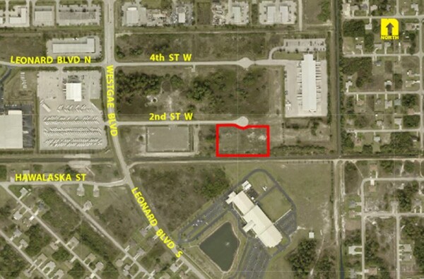
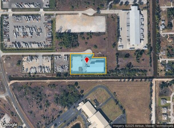
5519 2Nd St W, Lehigh Acres, FL 33971
NEARBY LISTINGS FOR SALE OR LEASE
Property Detail
5519 2Nd St W
Cape Coral-Fort Myers, FL
Lehigh Estates
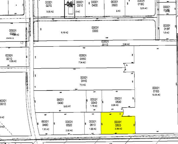
30-44-26-00-00001.0500
LEHIGH EST UNIT 1 POR VAC R/CANALS + BLK DESC IN OR 4353 PG 4634
Lightindustrial
Lee
X
Florida
12071C0475F
50
2024
2.35 AC
2025
Lehigh
040121
Southwest Florida
22,254 SF
DEMOGRAPHICS near 5519 2Nd St W
1 Mile
3 Mile
5 Mile
2024 Total Population
7,302
45,719
99,280
2029 Population
8,500
53,873
118,107
Pop Growth 2024-2029
+ 16.41%
+ 17.84%
+ 18.96%
Average Age
33
39
40
2024 Total Households
2,195
15,739
35,673
HH Growth 2024-2029
+ 15.95%
+ 17.66%
+ 19.12%
Median Household Inc
$57,937
$68,964
$69,869
Avg Household Size
3.20
2.80
2.60
2024 Avg HH Vehicles
2.00
2.00
2.00
Median Home Value
$258,614
$283,650
$282,436
Median Year Built
2004
2004
2006
Nearby Places
Map Layers
Map Styles
 Street
 Aerial
- Restaurants
- Banks
- Shops
- Fitness
- Groceries
PUBLIC TRANSPORTATION
AIRPORT
Southwest Florida International
DRIVE
WALK
Distance
Southwest Florida International
17 min
7.1 mi
Punta Gorda
DRIVE
WALK
Distance
Punta Gorda
38 min
29.4 mi
SALE & LEASE HISTORY
LISTING DATE
SALE/LEASE

Nov 08, 2016
For Sale
Nearby Properties
Address
Land Use
TOTAL SIZE
Lot Size
Zoning
Address
Land Use
TOTAL SIZE
Lot Size
Zoning
24.69 AC
C-1
Address
Land Use
TOTAL SIZE
Lot Size
Zoning
519,706 SF
95.18 AC
RS-1
Address
Land Use
TOTAL SIZE
Lot Size
Zoning
111.70 AC
C1
Address
Land Use
TOTAL SIZE
Lot Size
Zoning
17.50 AC
C1
Address
Land Use
TOTAL SIZE
Lot Size
Zoning
333,614 SF
294.30 AC
AG-2
Address
Land Use
TOTAL SIZE
Lot Size
Zoning
154,653 SF
11.77 AC
SDA
Address
Land Use
TOTAL SIZE
Lot Size
Zoning
135,503 SF
15.29 AC
AG-2
Address
Land Use
TOTAL SIZE
Lot Size
Zoning
68.11 AC
PUD
Address
Land Use
TOTAL SIZE
Lot Size
Zoning
75,477 SF
13.12 AC
SDA
Address
Land Use
TOTAL SIZE
Lot Size
Zoning
29.75 AC
CI
Address
Land Use
TOTAL SIZE
Lot Size
Zoning
85,812 SF
15.76 AC
PUD
Address
Land Use
TOTAL SIZE
Lot Size
Zoning
95,220 SF
3.23 AC
SDA
Address
Land Use
TOTAL SIZE
Lot Size
Zoning
2.10 AC
C1
Address
Land Use
TOTAL SIZE
Lot Size
Zoning
106,286 SF
16.57 AC
PUD
Address
Land Use
TOTAL SIZE
Lot Size
Zoning
142,693 SF
5.97 AC
C-2
Address
Land Use
TOTAL SIZE
Lot Size
Zoning
43,676 SF
10.48 AC
CF-2
Address
Land Use
TOTAL SIZE
Lot Size
Zoning
35,579 SF
8.06 AC
SDA
Address
Land Use
TOTAL SIZE
Lot Size
Zoning
108,797 SF
7.39 AC
IL
Address
Land Use
TOTAL SIZE
Lot Size
Zoning
35,974 SF
3.16 AC
IL
Address
Land Use
TOTAL SIZE
Lot Size
Zoning
70,622 SF
2.17 AC
CPD
Address
Land Use
TOTAL SIZE
Lot Size
Zoning
76,999 SF
34.31 AC
C-2
Address
Land Use
TOTAL SIZE
Lot Size
Zoning
11.76 AC
SDA
Address
Land Use
TOTAL SIZE
Lot Size
Zoning
6,710 SF
1.24 AC
SDA
Address
Land Use
TOTAL SIZE
Lot Size
Zoning
8,080 SF
1.40 AC
PUD
Address
Land Use
TOTAL SIZE
Lot Size
Zoning
35,087 SF
3.34 AC
MU
Address
Land Use
TOTAL SIZE
Lot Size
Zoning
16,080 SF
1.90 AC
PUD
Address
Land Use
TOTAL SIZE
Lot Size
Zoning
13,953 SF
2.43 AC
MU
Address
Land Use
TOTAL SIZE
Lot Size
Zoning
56,183 SF
221.30 AC
PUD
Address
Land Use
TOTAL SIZE
Lot Size
Zoning
19,085 SF
7.30 AC
PUD
The World's #1 Commercial Real Estate Marketplace
Connect with us
© 2025 CoStar Group
The information above has been obtained from sources believed reliable. While we do not doubt its accuracy we have not verified it and make no guarantee, warranty or representation about it. It is your responsibility to independently confirm its accuracy and completeness. Any projections, opinions, assumptions, or estimates used are for example only and do not represent the current or future performance of the property. The value of this transaction to you depends on tax and other factors which should be evaluated by your tax, financial, and legal advisors. You and your advisors should conduct a careful, independent investigation of the property to determine to your satisfaction the suitability of the property for your needs.